Every meteorologist and weather enthusiast owes it to themselves to see Pressure.
If you miss it in theaters, catch it on streaming when it’s available.
This humid airmass we've been stuck in for the last couple of weeks finally gives us a break early next week!
Drier air turns rain chances lower, but also turns us a bit warmer especially on Monday and Tuesday.
Don't get too used to it. Rain chances return late next week.
Rain chances stay elevated through the weekend, but don't cancel those outdoor plans!
Similar to Memorial Day weekend, keep an eye on radar, and be prepared to quickly move indoors if one of those brief afternoon downpours pop up over your location.
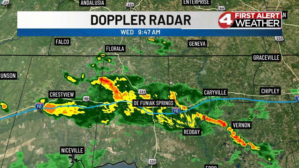
Isolated downpours are already moving across the southwest corner of the Wiregrass late this morning while we're dry, warm, and very humid in Dothan under partly sunny skies.
Watch out for some pockets of heavy rain as showers and storms return to the area this afternoon.
Even if you got a break in between pop-up downpours, beach conditions aren't looking the best along the Gulf Coast.
A high rip current risk is expected through late Saturday night. Be mindful of beach flags before you head to the sand this weekend!
The latest update to the drought monitor features another sizeable improvement in drought conditions around the Wiregrass.
The entire area is still under severe drought, but the extreme drought is now limited to parts of Bay County in the Florida panhandle.
We're drying out after another round of showers and thunderstorms yesterday afternoon, but it's still a cloudy start to our Thursday with temperatures in the middle 70s.
Don't expect a whole lot of changes this afternoon! Showers and storms return once again by midday.
A lower coverage of scattered showers and thunderstorms each afternoon through the rest of the week will bring smaller rainfall totals into the Wiregrass.
There will still be multiple heavier spots that see 1" or more of rain, but most spots likely see 0.25" to 0.50".
Heavy rain is coming down along Interstate 10 across the Florida panhandle this morning while the rest of us are dry with cloudy skies.
Coverage will be a little lower today, but we'll still see scattered showers and thunderstorms pop up around the region this afternoon.
People are likely a little on edge about the potential for severe weather today after what we saw yesterday. The good news is that organized severe weather is unlikely around the Wiregrass.
We could see some gusty winds in the heavier downpours, but that's it.
Isolated to scattered showers and thunderstorms developing through the middle of the day become more numerous later this afternoon and into the evening.
Heavy rain on top of already saturated soils could cause some isolated areas of flooding through late tonight.
Things are much quieter this morning after a very stormy Monday evening across much of the region.
We're dry with partly sunny skies in place right now, but scattered showers and thunderstorms return to the region once again by around midday.
It's wet at times for the next several days! Rain chances hover between 40% and 60% through the end of the week.
It's not the greatest outdoor weather, but it will continue to knock a bigger dent in the ongoing drought conditions still in place.
Tornado warning in effect just to the east of our area.
People in eastern Seminole County in southwest Georgia needs to keep a close eye on this. We'll cover it if Seminole County goes under a tornado warning.
After a break last night, rain is once again moving into the region as we kick off our Monday morning.
Showers and thunderstorms become more scattered, then widespread as the day rolls on, and be prepared to see some pockets of heavy rain too.
The first handful of pop-up downpours are underway across portions of the Wiregrass late this morning.
Keep those outdoor plans, but keep an eye on the radar too! Most downpours last as long as 30-45 minutes.
Rain becomes more widespread starting on Monday, and we'll continue to see rounds of widespread rainfall develop over the area through much of the week ahead.
We're looking at another beneficial round of 1 to 3 inches of rain across the southeast between Monday and Friday.
Coverage increases, but showers and thunderstorms will stay scattered across the Wiregrass through Memorial Day weekend.
Rainfall totals will mostly be around 0.50" for those that see rain. Some heavier storms could push rainfall totals to around 1.00".
Isolated showers and thunderstorms once again pop up around the Wiregrass this afternoon!
Coverage of storms should be around 30%, and any rain should quickly wind down this evening. We'll watch for a stray shower or two that could still linger into the night.