Storm Chasing App & Web Map. Fastest Updating Interactive Radar. Full Res Level 2 and live chaser streams. Get the map for your site! [email protected]
NEW January 2021 - Radar Tile API for developers. We offer a generous allotment of tiles for free and inexpensive monthly plans. Super resolution data, snow/ice mask and 3 minute radar updates. Check out our tile implementation documents and pricing here https://t.co/7hKgc0K17E
In a warmer climate, snow levels rise and snow pack decreases by a HUGE amount. Why? Think about the difference in width of the mountain base vs peak. The drop in snow pack area is huge. (This is an idealized graphic, numbers are only to help explain). The result is this… 🧵 1/
Earth’s September heat was so Gobsmacking Bananas 🍌 hot, and so far outside of the historical temperature distribution, that you have a much better chance of winning the $1.4 Billion PowerBall many times over!! So get your tickets!! https://t.co/35Cia2lwYY
The immediate Tampa Bay Area is notorious for dodging big hurricanes. The last direct hit (Cat3+) was 102 years ago! Are we just lucky or is this normal? To find out @WFLA went next level, partnering w/ @Columbia@columbiaclimate for an in-depth study! https://t.co/C9vwqeRhVK
The daily tidal range in the Bay of Fundy is 50 feet. Already extreme. Which side of the Bay Lee comes ashore will make a complete difference in the outcome here.
The Bay of Fundy has the highest tidal range in the World - nearly 50 feet! #HurricaneLee may make landfall miles from there, which would be not only very dangerous in terms of surge (if timed right with incoming tide) but also a unfortunate science experiment. Depending on 1/
It’s a monster. But it will avoid Florida and most of the eastern seaboard. Questions emerge about New England and the Canadian Maritimes longer term. Stay tuned!!
#HurricaneLee is forecast to peak Friday morning with maximum sustained winds of 180 mph. If that happens, it would put Lee in an elite club, with 8 other storms reaching 180 mph. 5 Atlantic hurricanes on record have had stronger winds. The max: Allen in 1980 had 190 mph winds.
Breaking: Lee is now a category 5 storm forecast to reach 180 mph by AM! The frequency of category 5 storms has increased significantly in the past decade due partly to hotter water. No telling what the future will bring, but one thing is for sure, waters will continue to warm.
Breaking: #HurricaneLee is now a Cat 5 storm, with winds of 160 mph. In 30 hrs it intensified 90 mph, 2-3X the criteria for rapid intensification. In the past 8 years, there have been 8 cat 5’s in the Atl. Comparing 1970-2000 with 2001-2022, cat 5 frequency has tripled! 1/
At 11pm it’s very likely #HurricaneLee will be a cat 5, rapidly intensifying at more than 2X the criteria!! Taking a look at the Tropical Cyclone Heat Potential, #Lee has really just entered the stretch hotter ocean temps. Will be interesting to see how intense it can get! 1/
55 mph of intensification in 24 hrs, obliterated the criteria for Rapid Intensification. Wait for it… You’ll see in this animation the water ahead of the storm is even hotter, 3-5 degrees above normal. Cat 5 by forecast tonight may do 90mph in 36 hours!! #HurricaneLee@WFLA
#Lee may reach cat 5 status by weekend. A big reason: an “unreasonably” (record shattering) hot ocean. Below both sea surface temp anomalies & actual SST’s are shown. +3 to +5F above normal in our heated climate increases the odds of this and rapid intensification tremendously 1/
Europe is having one of the most textbook Omega blocks in memory. A heat dome flanked by two strong storms. A true atmospheric stalemate/ traffic jam, dumping Epic rains in Greece. These split flow jet streams & extreme blocks are becoming more common esp in Europe 1/
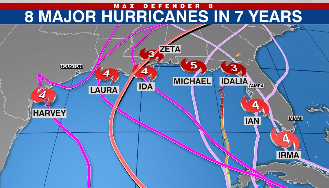
8major landfalls in past 7 yrs! While we can't attribute the general landfall locations (Gulf) to climate change (short data period) what we can say is that it's not coincidence (hotter water) that storms are getting stronger and rapidly intensifying (right up to landfall) @WFLA
This is a very useful tool. We have it live on our website all the time. The @WFLA Real-time looping Wobble Tracker. You can see when the eye wobbles off course OR if the storm is moving off course of the NHC forecast. Position updated through tomorrow. https://t.co/n0hitmXhWe
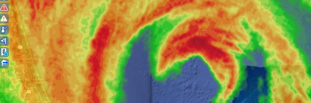
NHC's new surge forecast ticks higher for the Tampa Bay Area, now with 7-11 ft Crystal River, 7-9 ft in New Port Richey & 4-7 feet Clearwater Beach, St Pete Beach and even inside Tampa Bay - St Pete downtown, Tampa downtown. Expect low-lying coastal roads to be inundated. @WFLA
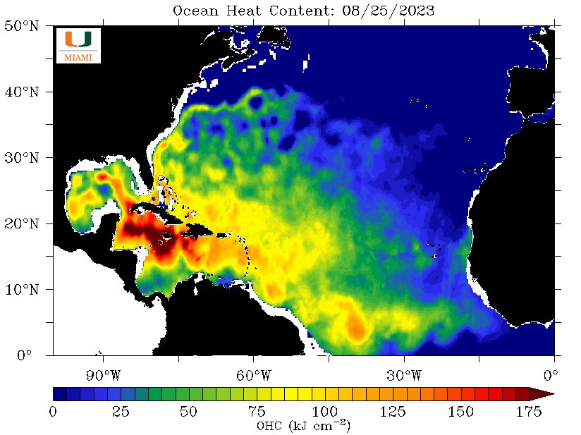
#Invest93L near Yucatán is in the most energy laden water in our Hemisphere. It’s not only hot, but deep, and that’s why ocean heat content is maxed out. B4 it can take true advantage of that, the system needs to organize. This next GFX shows right now the enviro is perfect 1/
Here’s a look at the various operational model tracks starting Sunday AM, ending Wednesday PM. Based on the latest of either 12z or 18z data. GFS=American model. CAN=Canadian. UK=UK model. ICON=German model, EC=European model. Attn FL West Coast. Says zero about intensity. @WFLA
A testament to how extreme & overwhelming the climate is this summer is, this Record “Shattering” heat dome has been barely covered by the national media. It’s largest US heat dome in recent memory and in a large part of the nation’s middle the most intense, by a long shot. 1/
Tons of Saharan dust traversing the Atlantic right now. That will thin out big time next week and allow for better chances of tropical cyclone genesis. However, given the shear (below post) it will be tough for storms to be left alone for long a enuf to gain sustained intensity.
Fascinating weather upcoming! Intense-Expansive heat dome builds over central US this weekend. Along West Coast upper low/ trough. Steering between the two attempts to lift a possible tropical system (#Hilary ?) north near SoCal. Meanwhile in the Gulf a tropical wave attempts 1/
“We are surprised by the pace. It is unprecedented what we have seen,” said Scott Atwell from theThe Florida Keys National Marine Sanctuary. “We’ve never seen anything like this. Some are not even bleaching, they are going straight to dead.” @WFLA https://t.co/wgOgYwmxAK
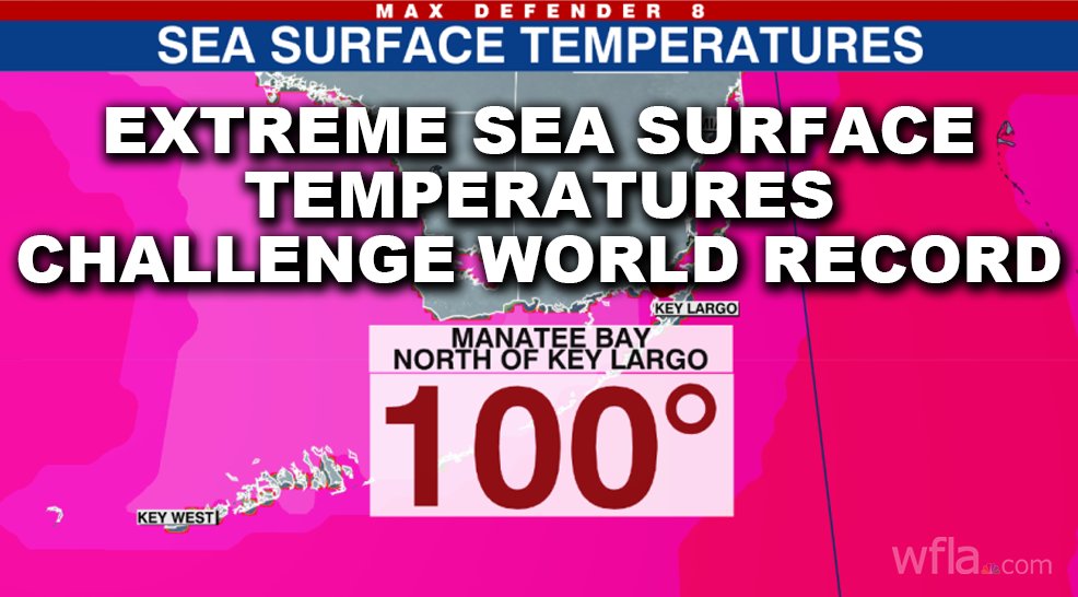
Incredible. 101 degree water temperatures near the Florida Keys today. 3 different NOAA sites recorded 98 plus, 2 over 99, and 1 at 100+. @SevereStudios
Actually it briefly reached 101 late today! If verified, this would challenge the hottest sea surface temperature ever recorded on Earth. Much more detail here and nuance too... @WFLA https://t.co/qzbaPqrbf8