Dry and very hot day throughout the state tomorrow with maximum and minimum temperatures well above average.
Light northeasterly winds tending to moderate north to northwesterlies in the afternoon.
Fire Weather and Heatwave Warnings current.
More: https://t.co/oDsq2TAyDq
Unusually hot October weather in Outback Queensland, a dangerously windy Wednesday over SW Victoria and SE South Australia ,stormy in the west. 🥵⚡️. Gotta love spring down under!
@paulwiggins@PaulHiggins@BenedictBrook I don’t need AI to tell me the obvious. I never see national TV news programs saying there’s been an accident on Melbourne’s Eastern Motorway. Or similar. And guess what Mr Editor? They’re usually done from Sydney for a national audience. How does that work for the AI slop?
@paulwiggins@PaulHiggins@BenedictBrook You obviously don’t think about using the correct words. Yet you say you’re an editor. Local vernacular is what matters. Very simple rule of journalism.
@paulwiggins@PaulHiggins@BenedictBrook You use the proper road names which are all listed as freeways on every map. That’s what local readers would naturally expect, unless you wanted to show them you were an out of towner. Simple really.
With #Melbourne's top temperature reaching 20°C, the city has now recorded its earliest instance of 4 consecutive 20s (prev 17-20 August 1995). It is also the 2nd instance of a rainless fortnight in August (after 1899). Parts of W Victoria will receive welcome rain tomorrow.
For those wondering where I’ve got to on
@abcnews Channel, they have decided to go in a different direction. A huge thanks to all who I’ve spoken to and had contact with during my time on air! Still hanging in there on 7pm VIC news. #abcnewschannel@JoeDoesNews
Taking long service leave has been wonderful. But like all good things, it’s coming to an end. Hope you can join me once more with Tam and Isk from next Monday at 7pm. @abcnews
.@phitchener9 This is so sad Hitch. I hope it was your choice alone. Looking forward to still seeing you on the weekends for as long as you want to be there!
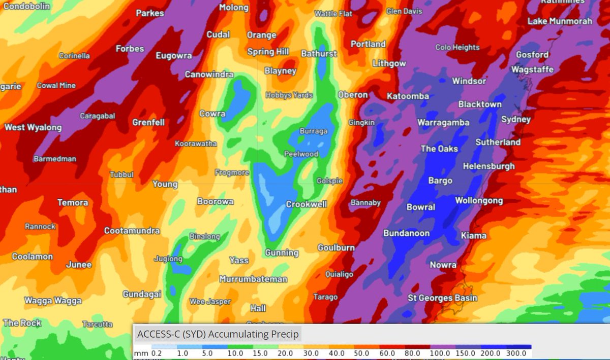
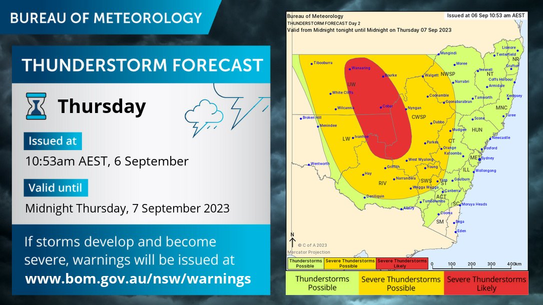
🌩️Thunderstorm forecast Thurs 7 Sept: Gusty thunderstorms expected across inland #NSW, spreading east during the afternoon/evening. Warnings may be issued. Prepare by tidying up loose items around your home & yard.
Monitor conditions at https://t.co/0kBlJ1d3MC
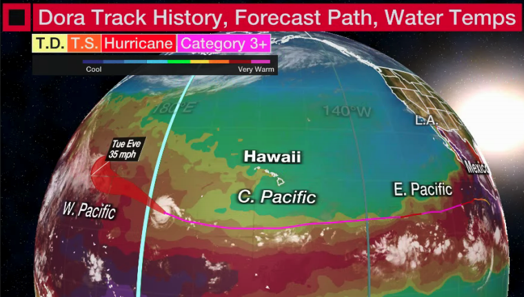
Late this evening, #Dora will cross the International Date Line, and will then be known as a #typhoon.
Only 2nd known system to have completed the EPAC hurricane -> CPAC hurricane -> WPAC typhoon trifecta in reliable modern records. (John 1994)
JUST IN: The remarkable Hurricane #Dora has become Typhoon Dora, crossing the international date line and becoming only the 2nd storm on record to maintain hurricane strength in eastern, central & western Pacific. https://t.co/sBRoMshThN
The unreal story of Hurricane Dora:
- Emerged July 19 off the African Coast as tropical wave
- Became tropical depression July 31 in the Pacific
- Longest lasting Category 4 hurricane on record in Pacific
- Currently a Category 3 storm near West Pacific
- Over 10,000 mi traveled
A low pressure system off the NSW coast will bring heavy to intense rain and damaging winds to parts of eastern #Victoria from Sunday morning. Rainfall totals of 80-150mm are possible over East #Gippsland tomorrow, with moderate to major flooding likely.
https://t.co/tWglOEOdf9