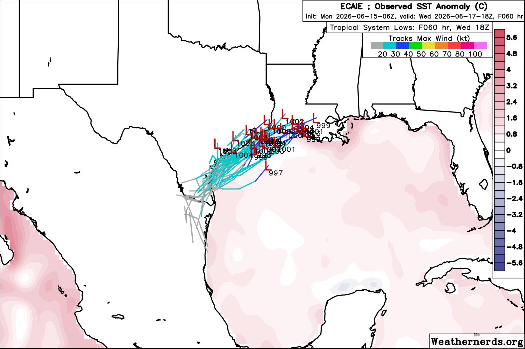
NHC up to 60% on #90L this morning. Enough to warrant our first tasking of the season! Survey mission (lots of dropsondes) planned for Tue night with a 10:45pm CT takeoff. I will be on the follow-on mission for the first flight into the storm scheduled for a 4:30am Wed am takeoff, if necessary. This could slip to the afternoon if it takes longer to develop or emerge over water.
FIRST TRACK for the disturbance about to enter the Gulf. It’s expected to become Arthur on Wednesday. A Tropical Storm Watch is now up for the Louisiana Coast. Most of the weather will be east of that track with this storm! #arthur#nola#louisiana#tropics
NHC has initiated advisories on Potential Tropical Cyclone One (formerly AL90) located over southern Texas. Potential Tropical Cyclone Advisories (PTC Advisories) are issued when there is high confidence that the disturbance will develop into a storm and bring significant impacts.
Potentially life-threatening flash and urban flooding is possible across the Texas coast eastward into central Mississippi through Thursday. Prolonged rainfall may extend the flood threat into the weekend. Widespread small stream and minor river flooding is expected along the Texas coast into southwest Louisiana, with isolated areas of significant river flooding possible across the Texas Coast and Louisiana.
Potential Tropical Cyclone One is forecast to become a tropical storm as it moves along or just off the northwestern Gulf coast through Wednesday. Tropical Storm Watches have been issued from Sargent, Texas, to Morgan City, Louisiana.
Minor to moderate coastal flooding is expected along portions of the Upper Texas and Louisiana coastlines.
https://t.co/e2Vkdav5Wu
Tuesday morning 12z spaghetti models for Invest 90 on https://t.co/mSxpZtuPu3. Showing little more time over water with a push little more east. Might buy some time to get spinning. Timestamps I circled as many ask for ideas of timing. 24 and 48 are hours from this model run. So tomorrow at this time 'center' likely over water.
Invest 90 bubbling up some big time convection tonight. Current satellite here. Tons of rain likely brewing from all this for the western and upper Gulf region, regardless of development. Watching unfold in real time. Website and APP updated with the latest. Small window to develop a low center over water before back over land in TX/LA. Arthur? https://t.co/0EQMEw6Iu0
Spaghetti Models at 00z for #Invest90L
Discussion
The Spaghetti Models are showing Invest 90L that will impact #Mexico, #Texas, #Louisiana, #Mississippi and #Arkansas and could lead to Dangerous to catastrophic Life Threatening flash flooding with the WPC putting out a Moderate risk of excessive rainfall for the Gulf States and SPC putting out a Marginal Risk for tomorrow and Thursday mainly for #tornadoes from this system and with the Model Intensity Guidance showing TS for intensity
#wxtwitter #wxX #wx #Tropicalwx #Tropicswx #Tropics #Hurricane #Hurricaneseason #HurricaneSeason2026 #TropicalUpdate #90L #AL99 #Arthur #txwx #stxwx #rgvwx #spiwx #houwx #glswx #lawx #arwx #alwx #gawx #scwx #ncwx #vawx
More concerned about South LA being the bullseye of heaviest rain with this storm. Weak storms trend east as the wind shear displaces the heaviest rain east. This could bullseye some portion of South LA for a significant rain event. Watch the trends as this comes off Texas #lawx
18z HRRR shows why this could be a highly impactful system this week. Whether it fully gets to a tropical system or not - it will have some upper level support and be very slow moving. It will likely produce some major rain and flash flood potential. Lopsided system with tremendous moisture surge on one side.
Talking about measuring rain in feet (plural) and not inches if this turns out to be correct. Somewhere in coastal TX or more-so coastal Louisiana could really get some big time rain totals from training convection Tuesday, Wednesday, and Thursday.
Multiple rounds of heavy rain through Friday due to a stalled front and tropical airmass, then Invest 90L.
🔹5-day totals: 6-10" (isolated 15-20")
🔹Flood Watch active (will likely extend)
🔹Coastal flooding possible Thurs/Fri
🔹Flash flood threat high; severe weather low.
Jun 15 2pm EDT: Key Messages for the Disturbance Over the Northwestern Gulf of America. Stay up to date with the latest at https://t.co/tW4KeGdBFb and https://t.co/SiZo8ozBbn


![iembot_lch's tweet photo. LCH issues Tropical Storm Watch for 10 forecast zones in [GM] until further notice https://t.co/X5hv3Uj1Eq https://t.co/0wXb6qbkMB](https://pbs.twimg.com/media/HK8b0ebXYAAoCZ3.png)