True success is not measured by what you keep.
It is measured by how many lives you touch, uplift, and inspire along the way.
Giving back will always be part of the journey.
AI is changing geospatial science. Are you keeping up?
Course 14 of YouthMappers Academy is here: Introduction to GeoAI — covering the concepts, tools, and ethics behind AI-powered mapping. No ML experience required.
Get Started → https://t.co/X5IN8XVrCz
#YouthMappers#GeoAI
Winners focus on progress, losers focus on excuses.
Every step forward counts, no matter how small.
Winners understand that growth is built through consistency, not comfort.
Excuses slow you down, but discipline and action create results.
Keep pushing, keep moving, progress is your victory.
Today is a fresh start, full of new strength and new possibilities.
No matter what yesterday looked like, this morning reminds you that you are still standing, still capable, and still moving forward.
Take this day one step at a time, believe in yourself, and don’t give up on the dreams in your heart.
You have everything you need to make today meaningful walk with confidence, stay hopeful, and let your effort speak for you.
Vegetation Indices Generator for Farms & Agricultural Monitoring (GEE Script)
Over the past few weeks, I’ve been working on a lightweight but powerful Google Earth Engine workflow designed for agricultural monitoring, tea farm analysis, and land-cover mapping.
Today, I’m excited to share the Vegetation Indices Generator — a script that automatically produces multi-season vegetation index composites and satellite imagery for any study area, anywhere, directly in Google Earth Engine.
🔥 What it Does
✔ Generates NDVI, EVI, SAVI, NDWI, GNDVI, NBR
✔ Creates seasonal satellite composites (Growing & Picking seasons)
✔ Includes RGB visualizations
✔ Exports Sentinel-2 spectral bands for deep learning workflows
✔ Performs seasonal change detection
✔ Outputs everything as GeoTIFFs ready for GIS/ML modeling
This tool was built with Kenyan agricultural workflows in mind — specifically tea farms in Bureti — but it works with any region and any crop.
👨💻 Use Cases
Tea crop health monitoring
Mapping stressed & underperforming farm blocks
Training data generation for semantic segmentation
Land-cover mapping
Multi-season change detection
Yield modeling & vegetation phenology analysis
☁️ Built on Google Earth Engine
No installation needed.
Just open the script → set your study area → run.
📥 Get the Script + Full Documentation
The full repository, instructions, setup guide, and sample outputs are available here:
👉 GitHub Repo: https://t.co/uKzk9KceZY
Follow @GodieMurithi for more GIS tools, remote sensing workflows, GEE scripts, spatial automation tips, and hands-on geospatial engineering resources published weekly.
🌍 At @OrionGeospatial
At Orion Terrametrics, we build geospatial automation pipelines—helping teams manage, share, analyze, and collaborate on spatial datasets effortlessly. From remote sensing workflows to real-time GIS dashboards and cloud-hosted geospatial infrastructure, we provide the tools that modern geospatial teams need to scale.
👉 Explore Orion Terrametrics: https://t.co/99ZziE5ZW7
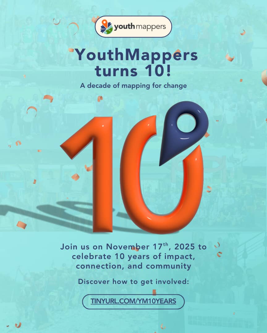
Over the past week, partners, collaborators, students, alumni, and leadership convened in NYC to celebrate our 10-Yr Anniversary together. 🎉
Read More: https://t.co/x5Q4tUiJ72
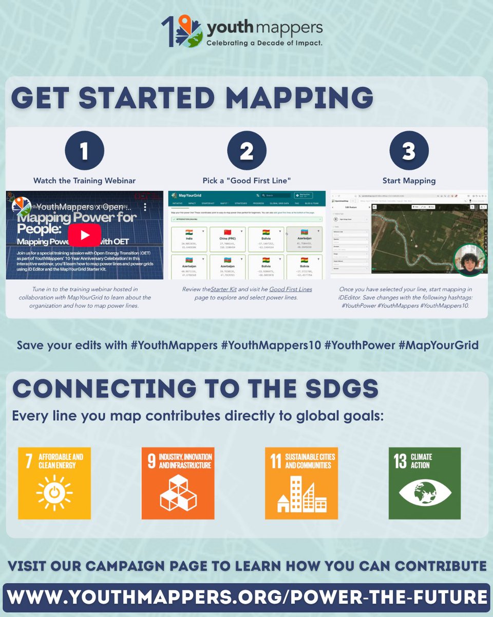
#YouthMappers#YouthMappers10#YM#YM10
For 10 years, @youthmappers has invested in young people creating opportunities for research, innovation, leadership, and global collaboration.
Are you proud to be part of this story?
#YouthMappers10
Hey YouthMappers around the globe.
We’re celebrating 10 years of impact! What has YouthMappers taught you over the years? Share two words with us in the comment session!😌
#YM10#YouthMappers
ChatMap Community Webinar – Oct 7
Join us for a 90-min exchange on how ChatMap turns everyday conversations into maps. No mapping experience needed!
🔹 English → https://t.co/o5hDFO1NTJ
🔹 Spanish → https://t.co/A98dMHIZTF
Learn more about ChatMap👉 https://t.co/lazRKdUC7n
The relaunch of the @youthmappers Academy includes a 3D course made possible by a Cesium Ecosystem Grant. The Academy removes barriers to access and makes it easier than ever to learn and contribute.
Learn more in this guest post by YouthMappers staff: https://t.co/MmldYsMShP
🚀✨ Meet our newly appointed YouthMappers Executives! ✨🚀
A fresh team of passionate leaders is here to drive our chapter forward with new ideas, energy, and commitment to mapping for impact. 🌍📍
GeoTogether, we map the future! 💫