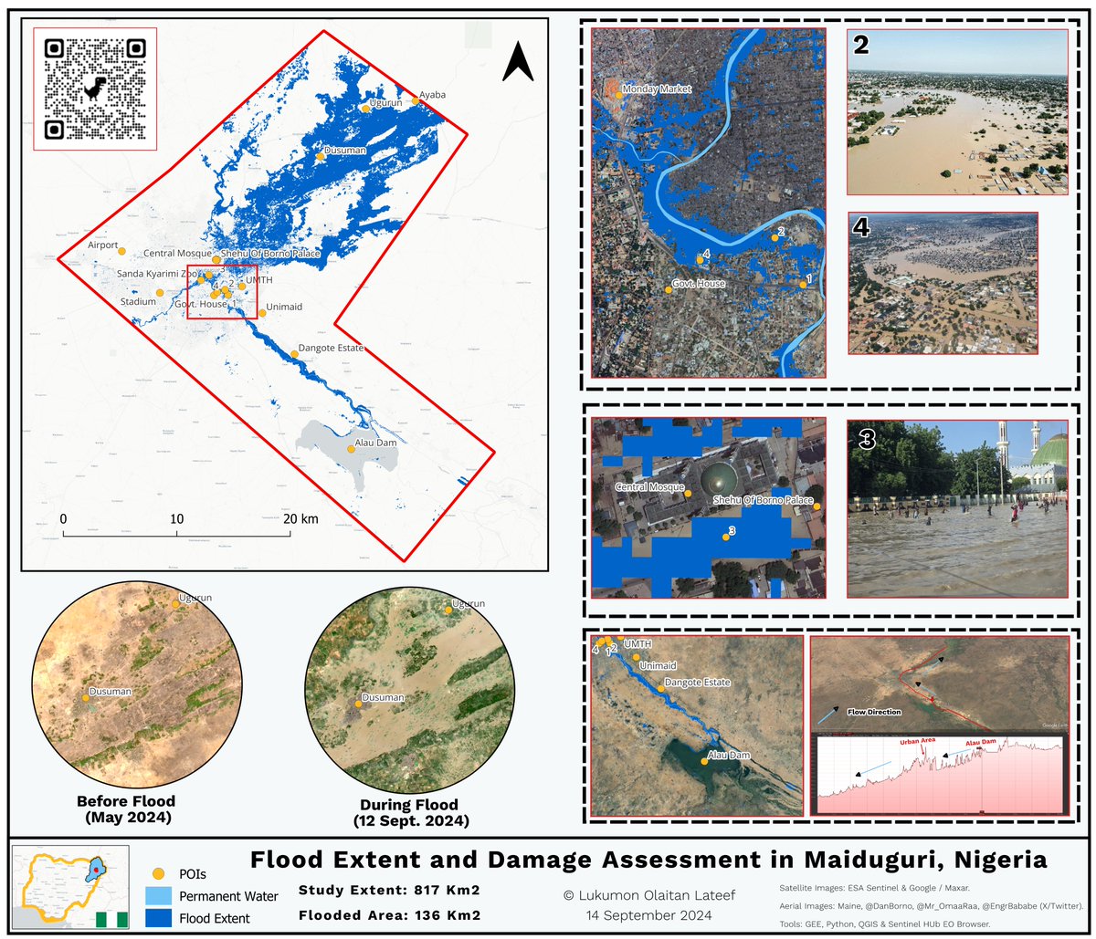
I conducted a preliminary flood extent mapping of the #Maiduguriflood using the available Sentinel-2 images and complemented the visualization with aerial images from social media users. I also assessed preliminary damage using the Open Street Map (OSM) building footprints.
Article is finally up. Completed this last week and thought now will be a good time to share.
I hope this resonates with someone and help them in their career.
#gischat
https://t.co/lnYrRmUWTj
My GIS people.
I promised that I'm going to carry our gospel to the ends of the earth.
As a result, I will be speaking at Datafest Africa @DataFestAfrica on Exploring the Potential of Geospatial Intelligence.
#GIS
Stark reminder of Earth's vulnerability: Devastating floods engulfed Sindh, Pakistan, in 2022. Sentinel-2 satellite imagery reveals the before and after, underlining the urgency of global environmental protection. 🌍📸 #EarthAtRisk#YP#REACT_TC@IEEE_GRSS@GrssYp
📣 New blog drop! A guide to free GIS data sources, ft. 100% biased and subjective movie-style reviews from me 👉 https://t.co/CuhAa1BTW8
Currently global & UK sources included, with more to come!
#gischat
I have officially graduated from Udacity Data Analyst Nanodegree program.
Thanks to @alx_africa and @Udacity for this opportunity.
Here is a link to my projects https://t.co/yQUxG97KrX
Dear Analyst and Techies, preparing for your Microsoft Certifications is now getting better. (Open post for link)
Why do some lecturers do all that is possible to make passing their course difficult?
Microsoft made available lots of exam preparatory materials and now even add preparatory test to it. All for FREE.
What a time to be in the Data and Tech Ecosystem.
Bookmark this tweet, Like, Retweet, Let's help people pass their Microsoft Certifications
Here is the link https://t.co/HwqYeSJnDL