Pocos entenderán el cruel sentimiento de lo que era ver a Freezer regresar tras la Genkidama, herir a Piccolo, Krilin ser explotado por los aires y que al día siguiente lo que veíamos era a Raditz nuevamente.
#Heads_Up :
Possible Return of cold to #Western#Europe near the 2nd decade of December. ❄️🌬️
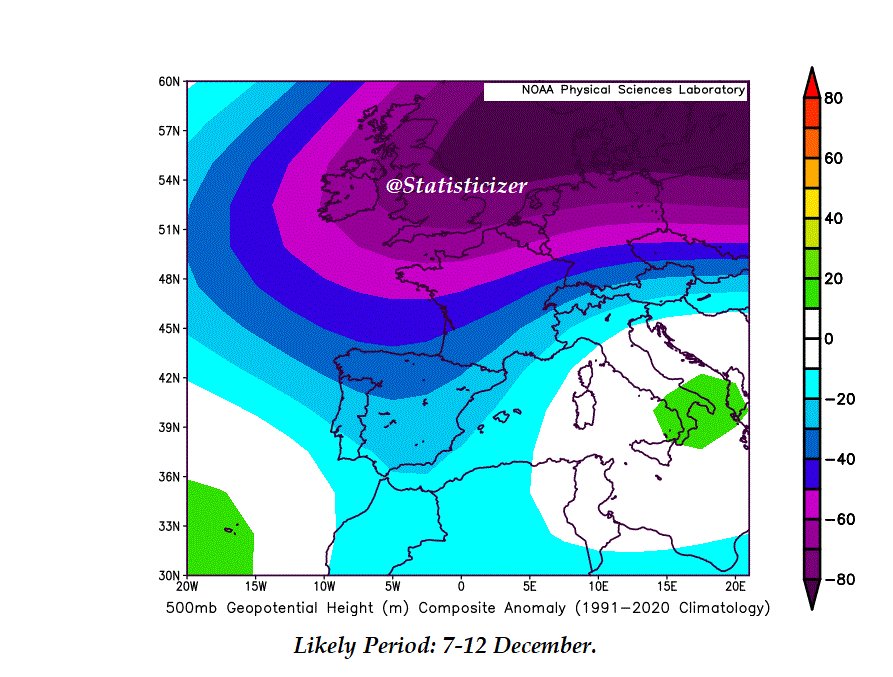
The analogous yielded 500 hPa height-anomaly composites (attached) continue to signal a renewed cold return toward Western & Southwestern Europe during the second decade of December, especially between 7–14 December, and most likely after the 8th.
🟪 Deep negative height anomalies across the UK, France, the Low Countries, Germany, N Spain, and extending toward the W Mediterranean strongly point toward a Negative East Atlantic (EA–) pattern coupled with a Negative North Atlantic Oscillation (NAO–).
This combo typically enhances cold intrusions, strengthens meridional flow, and supports cyclogenesis across the western Mediterranean.
🌡️ Before this cold reload, the period 1–7 December shows a temporary Positive NAO / Azores ridge phase, bringing a short-lived stabilization.
🏔️ Snow Potential:
• High altitudes in N Spain and parts of the Pyrenees
• Very high elevations in Morocco (Atlas range)
are the most favored under this synoptic setup.
📉 The second attached map (9–14 Dec) shows a persistent low-height field extending toward France, Spain, W Italy, and even pushing into the central Mediterranean — consistent with recurrent cold drops and increased precipitation risk.
A sample of rainfall pattern is attached in the comments. Balearic sea and North Spain and France are likely regions for flood risk.
🔮 Heads-up#2: Another potential cold intrusion could emerge between 18–24 December, this time more focused on the Western Mediterranean, with stronger 850 hPa negative anomalies (i.e., colder thickness values). I will post a separate detailed update on that weather outlook later.
🟣❄️ #DICIEMBRE ☔️
#Intermedio
Se prevén dos episodios similares de lluvias intensas al actual, hacia mediados y finales de diciembre, que podrían afectar a la Península Ibérica y el Magreb.
🌧️ Estos periodos lluviosos podrían manifestarse como episodios intermitentes de precipitaciones, aunque algunos de ellos podrían intensificarse y abarcar áreas más amplias durante diciembre y su transición hacia enero.
Durante el episodio actual de lluvias (5–15 de noviembre), conviene vigilar las regiones de Gibraltar, el oeste de Portugal, el suroeste y sureste de España, así como las llanuras orientales, ante el riesgo de inundaciones y lluvias torrenciales que podrían superar las cantidades pronosticadas por los modelos numéricos.
🔸 Estos modelos suelen estar programados para subestimar las precipitaciones hasta que el evento ya está en curso — es decir, “nos avisan de que nos estamos inundando casi a última hora”.
🗺️ Las imágenes adjuntas corresponden a dos periodos lluviosos previstos para diciembre, donde los colores azules y púrpura 🟣 intenso indican respectivamente lluvias y lluvias severas.
---
🧊 Hallazgos intermedios adicionales:
Los análisis estadísticos y análogos más recientes indican que diciembre podría ser más frío de lo habitual, con presiones más altas a nivel medio del mar (MSLP) y presiones más bajas en niveles superiores.
📉 Este patrón podría reducir la cantidad total de lluvias durante parte del mes, pero aumentar la probabilidad de nieve y condiciones más frías, especialmente en el suroeste de Europa, donde podrían darse episodios de nieve temprana o poco habituales, así como en las regiones orientales del Mediterráneo.
📸 Las fotos adjuntas son solo algunas muestras de días de diciembre; pronto se publicarán más detalles.
#Lluvias #Frío #Nieve #Diciembre 🟣❄️
This year is really trying to do its best Dec 2010 impression to open up winter
Things are evolving quite a bit different subseasonally & seasonally in the backdrop of this and I wouldn’t expect sensible impacts to be anywhere near the same, but this is intriguing nonetheless
Of significant interest is forecast stratospheric zonal wind to be significantly weaker than average into late Nov/early Dec.
The signal is strengthening with mean down to 10m/s in last week of Nov when average is 30m/s, this suggests Atlantic jet stream will likely be weaker than normal and further south. With a higher likelihood of drier and colder conditions developing further into Nov.
La Niña also encourages blocking patterns in N Atlantic during early winter, implying these blocked patterns could become more ‘stuck’ with scope for a prolonged colder period in Europe.
An interesting cluster of model runs are interested in zonal westerlies reversing to easterlies the last SSW to occur in November was in 1968, so very rare, and in December 2001. Seasonal models get a lot of flack but updates from summer, had been suggesting a weak vortex in late Autumn 2025 with strong easterly QBO. This is looking to manifest.
The next few weeks are going to be very interesting! 🧐
Aitor Zelaia eta Galder Barbado gazteei elkartasuna adierazteko eta euren egoera salatzeko, Antiguako Matia kalean ekintza egik du @ErnaiDonostia|k.
@irutxulo
Extremely proud to helped the team winning this important trophy for the 1st time!
Thank you to everyone in the club that was involved in this great achievement and to my familly and friends for always being by my side!
Fantastic support by our fans!This also belongs to you!💛💙
🔴 DEBATE ELECTORAL | Patxi López, portavoz del PSOE: "Con diálogo y con medidas valientes, ha conseguido que se viva hoy en Cataluña esa recuperación de la tranquilidad y de la convivencia"