It's been 8 months since https://t.co/wGXFeDF4LJ launched. Today, it helped find the best shaded seat for the 50,000th route and it got over 63,000+ page views.
contd..
What is the most common starting sound in Malayalam movie names, 6620 movie titles analyzed
Even if you add the 'അ' and 'ആ' sounds together (755), they still can't beat the dominant 'ക' (758)
decoded Malayalam titles from Wikipedia. For the rest, built a custom converter based on the Swanalekha scheme by @smcproject ,with custom rules for English loaned words
CH: ച (e.g. Chemmeen) vs ക (Christian Brothers)
C: ക (e.g. Captain) vs സ (Cinema)
If you grew up in Kerala, you know what it feels like when the rains don't stop.
I grew up in Thrissur and I have seen serious flooding during my childhood and teenage years. Growing up, during monsoon we would sit glued to the radio and TV, listening to alerts from news channels about rising water levels and flood intensity, and honestly it felt less like a weather update and more like living through a survival thriller.
During my school and college days I remember going to science and tech fairs and see school and college students build makeshift flood indicators trying to solve a problem that kept entire communities up at night.
It was inspiring and heartbreaking at the same time, because the problem was real enough that many students during those times felt the urgent need to do something about it.
There were moments during those years, especially during the 2018 floods, where I thought about how helpless it felt to not know what was coming next and how badly people needed something more immediate than a broadcast.
Then yesterday I came across a LinkedIn post by Amith V Purushothaman that stopped me mid scroll.
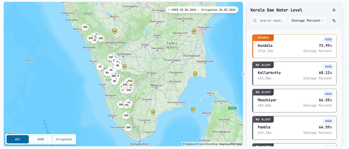
He built Kerala Dam Water Level, a live tracking website fully vibecoded that shows real time water levels of every major dam in Kerala, pulling data directly from KSEB and the Irrigation Department.
Here is what it does:
→ An interactive map showing live storage percentages across all major dams in Kerala.
→ Individual dam pages with water level, storage, inflow, outflow, spillway discharge, and rainfall data all in one place.
→ Alert level indicators across Yellow, Orange, and Red so you know exactly how close a dam is to critical levels.
→ Historical trend charts covering water level, storage, inflow, outflow, and rainfall so patterns become visible over time.
→ Filters for KSEB and Irrigation dams so the data stays relevant to what you need.
→ A built in timeline so you can track how levels have changed over weeks, months, or even years.
No app. No signup. Completely free.
What AI and vibe coding have made possible today is something those science fair students could only dream of.
A problem that once required radio bulletins and community alerts can now be tracked in real time by anyone with a phone and an internet connection.
At Kerala Product Hunt, this is exactly who we exist to find and amplify, builders who see a genuine public need and ship something that actually matters.
Check it out at https://t.co/JfUGtzcXQw and share it with your friends and families.
Cities like Kozhikode and Thrissur show less sharp peaks, with population more spread out.
Population forms a continuous dense belt along the coast rather than isolated high-density spots.
Satellite towns are visible around major cities.
Some Observations
Population concentrated in the west due to the western ghats, along with economic and historical factors
Population aligns along major roads (you can almost trace the MC Road) and also along some rivers
The only dense eastern pocket is around the Palakkad Gap