Sweet relief from the insane heat and humidity arrives today through Friday. Enjoy it, before likely shower, storm chances return for the weekend. Full breakdown in this morning's forecast discussion: https://t.co/xMd6OGarSh
We are excited to announce the launch of our first movie, NEVER STOP CHASING, coming to theaters this summer!
For details and show times, check out the website: https://t.co/9Fgx1M1utK
Here we observe the seismic waves racing out across North America from the recent very anomalous M6.1 reverse thrust earthquake that struck just off the west coast of Cuba. Weak shaking/jolts were felt across Cuba, Mexico's Yucatan Peninsula, and most of Florida.
🚨 MISSING PERSON 🚨
BGPD is requesting the public’s assistance in locating Bruce Cole. Mr. Cole has medical concerns and requires medication.
Last seen around 3 a.m. near Greenwood Mall/Cave Mill Rd. Known to frequent Fairview and the Bypass.
If seen, call BGPD: 270-393-4000.
Check out this incredible 3D trajectory of the parachuted sensor as it completed three revolutions around the #tornado, with widet circumference with height. The sensor then sampled the “vent” at the upper reaches of the dynamic pipe. It reached velocities of at least 140 mph. This is a historic accomplishment in science and engineering by @WillClay25
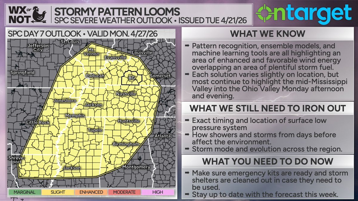
Monday (April 27) is a day we're keeping an eye on.
Pattern recognition, ensemble modeling, and various machine learning tools are indicating that a pattern favorable for severe weather could be shaping up as we head into early next week, specifically Monday. These tools are showing favorable wind energy overlapping an area of sufficient storm fuel somewhere across the mid-south/mid Mississippi Valley up into the Ohio Valley.
While this is something we're watching, please know that we are still nearly a week out from this, and parts of the forecast can and likely will change as we get closer. The atmosphere is a very complex beast and very hard to predict more than a few days out. We wanted to let you know that we're watching it carefully and will continue to update where we stand as we head through this week.
What you can do now is to make sure you know where your emergency kit is, take time to make sure it is stocked and ready to go should you need it. Additionally, if you have a storm shelter, make sure that it is cleaned out and ready to get to should you need it. And hey, even if we wind up not seeing severe weather next week, it's still spring! Better to have a clean shelter you don't need to go to than to need to make friends with the spiders that have made their home in there while yours is threatened by severe weather.
Be prepared, not scared, and know that we're keeping an eye on things as they evolve! In the mean time, enjoy the warm and dry weather we've got coming up the next couple of days!
(Posted on Tuesday evening, April 21, 2026. New maps from the Storm Prediction Center will release early each morning. If it is after mid-morning on Wednesday, April 22, 2026 when you see this, please seek more up-to-date information.)
MULTI-DAY #TORNADO OUTBREAK POSSIBLE Thursday-Monday from the central and southern Great Plains to Dixie Alley by Monday!
This map shows the five days of severe weather threat color coded by day. Thursday we may work the dry line from central KS/NE into Iowa, then settle down into the southern Plains for three days of severe weather and #tornado threat including here in Oklahoma. The #tornado threat expands into Dixie Alley by Monday.
Stay tuned as we nail down precise target areas for this uptick of severe weather
Taking my grandma on any storm chases near home has become a tradition of mine over the last few years. When I was 18 and did not have my own chasing vehicle, she stepped up to the challenge and would drive me around in her own Rav4 if I wanted to go chasing. Fast forward 4 years and now she has seen 11 tornadoes including this monster wedge shaped tornado near Kankakee, IL this past Tuesday.
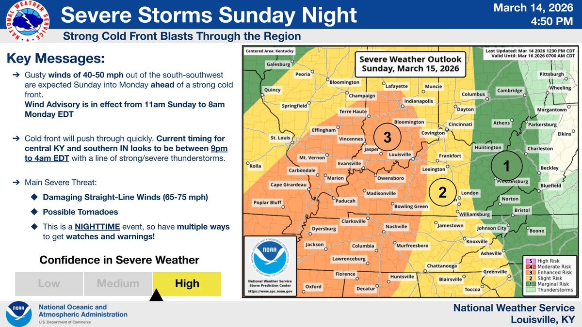
⚠️ SEVERE WEATHER POSS. SUN NIGHT! ⚠️
Cold front to bring strong/severe storms to central KY & southern IN.
Main Threats: Damaging Straight-Line Winds (65-75 mph) & Poss. Tornadoes.
Timing: 9 PM Sun - 4 AM Mon EDT.
This is a NIGHTTIME event! Have multiple ways to get warnings