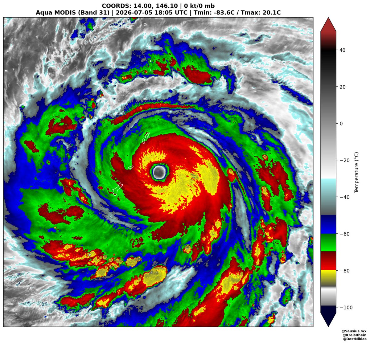
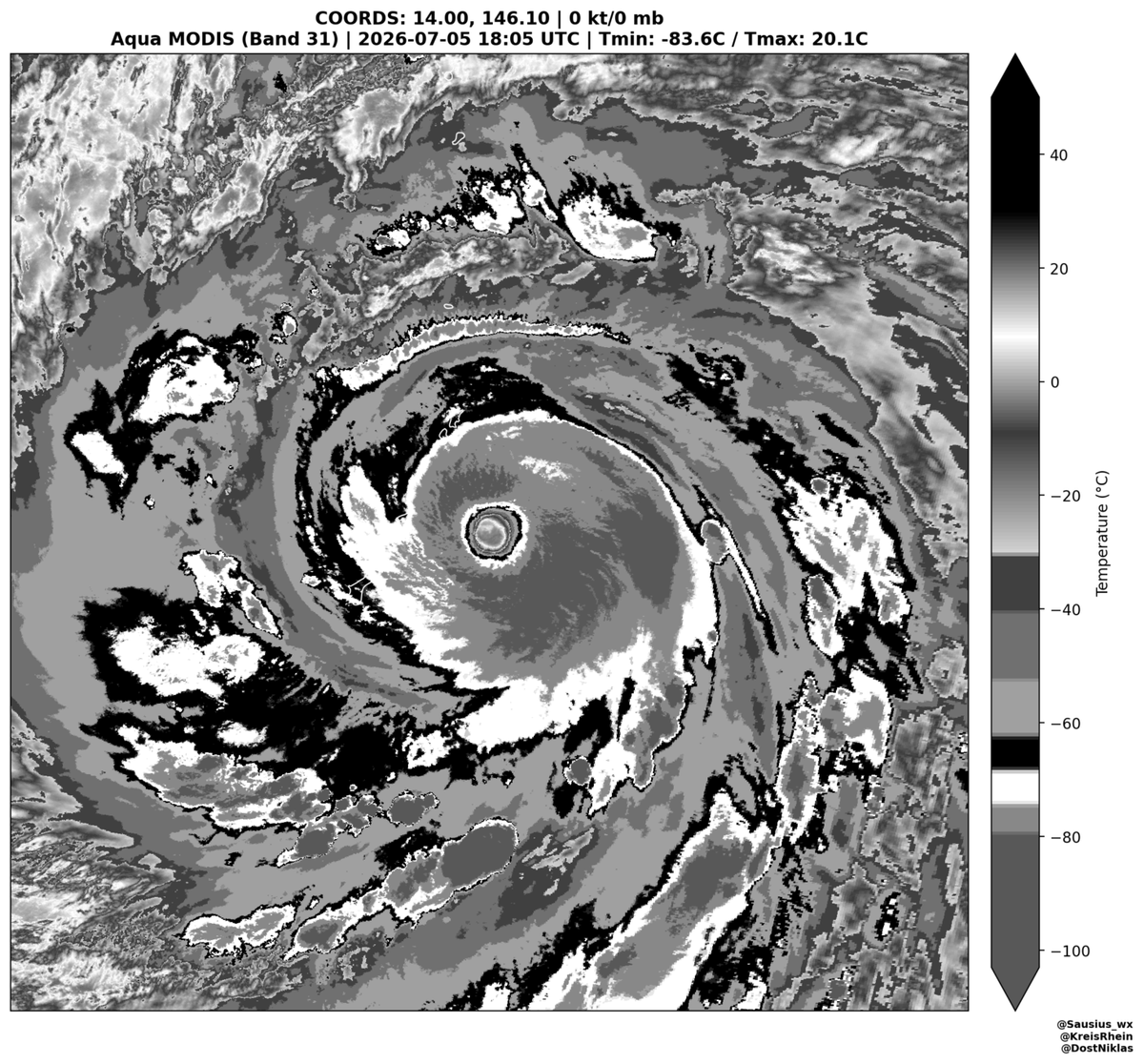
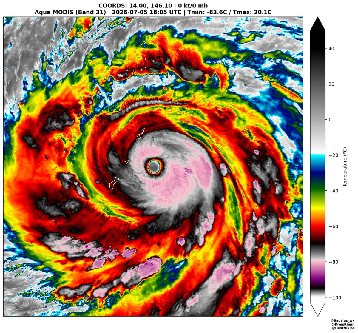
More Polar orbiting satellie images of Super Typhoon Bavi, this time coming form the MODIS imager aboard NASA's Aqua satellite, which captured these high-res images at 18:05 UTC. At the time JTWC estimated 1 minute sustained wind speeds of 285 km/h (180 mph).
CATASTROPHIC winds are now impacting the island of Rota.
Remain sheltered even as the eye passes, conditions will rapidly deteriorate again as the backside of Typhoon Bavi moves through, bringing another round of LIFE-THREATENING winds.
Lets pray for Rota 🙏
#tropicswx |
Well that might explain everything. There’s this huge westerly wind burst going on in the equatorial Pacific. That’s one of the reasons why we currently have so much activity in the WPac. And with #95W developing, we could see another typhoon on the way from there & one closer to the #Philippines.
Typhoon #Mekkhala impact!
This is how the Northwest Pacific systems helps #southwestmonsoon to progress and perform. The setting of axis of the monsoon, westerly jet is pulled from west indian ocean to west pacific. This sets the stage for monsoon to strengthen over India.
1/2
BREAKING: TY #FranciscoPH (#Mekkhala) becomes a SUPER TYPHOON by the @dost_pagasa.
It is the first super typhoon within the Philippine Area of Responsibility (PAR) this year. It now has 10-min average sustained winds of 185 km/h near the center and gustiness of up to 230 km/h.
Using the updated classification of TCs by PAGASA, it is the first super typhoon (≥185 km/h) in June inside PAR since STY Butchoy (Guchol) in 2012. It also tie as the second-strongest June typhoon of the 21st century, only behind STY Helen (Dianmu) in 2004.
Meanwhile, the Low Pressure Area (LPA 06c) that they are monitoring becomes a Tropical Depression.
📷: PAGASA
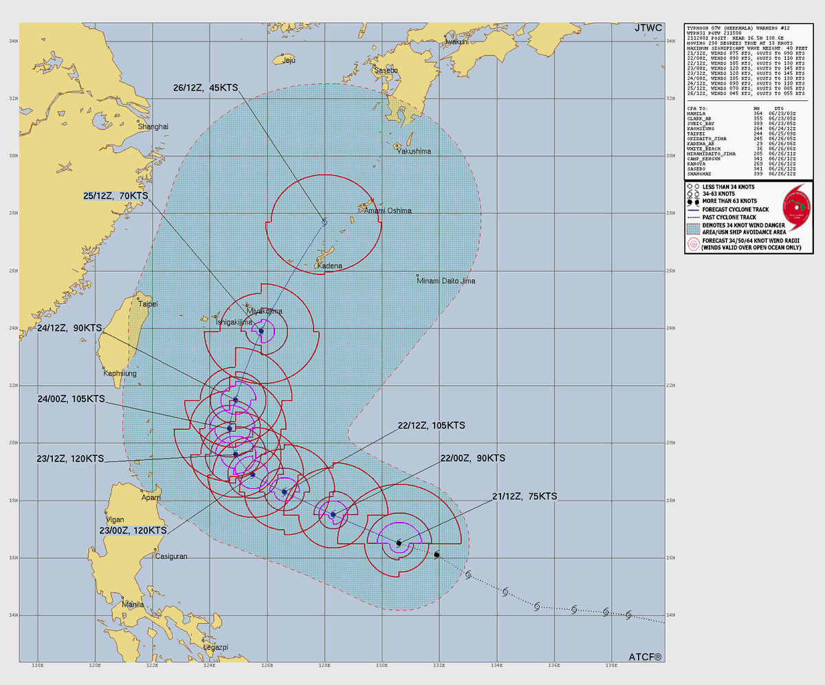
The Joint Typhoon Warning Center (JTWC) is now predicting Typhoon #Mekkhala (#FranciscoPH) to peak at Category 4 super typhoon (135 kts; 250 km/h) in the US scale (1-min winds) tomorrow, June 23.
If it happens, it will become only the second storm in June to do so this century, after TY Dianmu in 2004. Since records began in 1945, it has happened only seven times. ⚠️
📷: JTWC
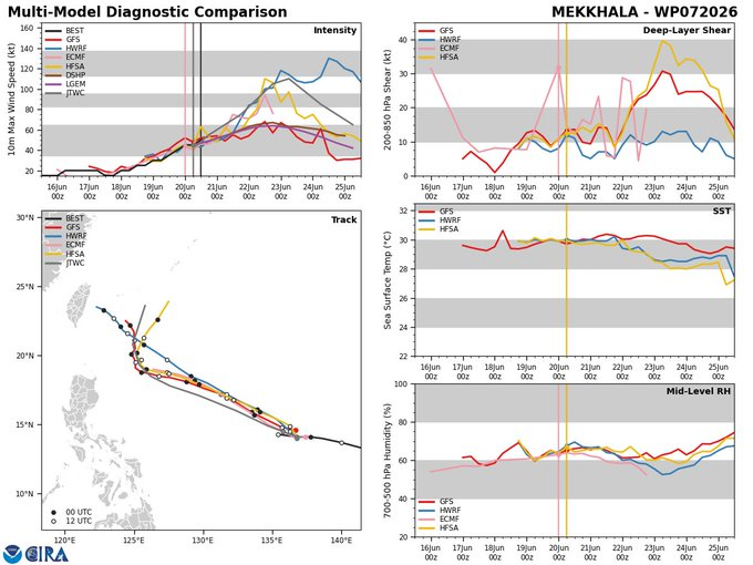
Typhoon #Mekkhala continues to battle shear in the West Pacific. It's not enough to totally stop intensification, but it seems to be enough to prevent RI.
Some of our HAFS diagnostics show the effects well. Just enough NE shear (15-20 knots) to undercut and choke the outflow to the NE, and create asymmetries in the secondary circulation (sinking motion on the upshear, NE side). The vortex also still is tilted to the SW in the model fields.
Typhoon #FranciscoPH (#Mekkhala) continues to intensify, as the overall environment remains conducive for additional intensification — with very warm sea-surface temperatures (SSTs), and strong radial outflow. A rapid intensification (RI) is expected to commence in the next few hours.
As of 8:00 PM (12Z), June 21, 2026.
PAGASA: 130 km/h (70 kts) [10-min]
JMA: 130 km/h (70 kts) [10-min]
JTWC: 140 km/h (75 kts) [1-min] {Category 1}
The movement of the storm is being steered by the subtropical ridge (HPA) to the north — hence, a generally west-northwestward track. This will continue until Wednesday, June 24, before turning poleward as the HPA weakens due to a passing trough from China.
There has been no change in the forecast intensity — with the JTWC predicts a peak of equivalent to a Category 4 typhoon in the US scale, while PAGASA and JMA at 165 km/h, and 155 km/h, respectively.
Note: Landfall in the Philippines is UNLIKELY.
HOWEVER, the Southwest Monsoon (#HabagatPH) being enhanced by TY Francisco will bring heavy rains in some parts of the western portions of Luzon and Visayas beginning tomorrow, June 22.
📷: Himawari-9 via NRL-Monterey, JMA via WNJP
A disturbance along the ITCZ in the Central Pacific looks innocuous but may be one to watch in the medium to long range. There are hints this disturbance may try to develop as it crosses the International Date Line into the Western Pacific.
Mekkhala has become a typhoon since I last checked in on her. MW and MSI from this morning indicated a healthy cyclone about to complete core formation. Since then a bit of a hiccup it seems, likely due to shear. Now looking good again and propably embarking on a period of RI.
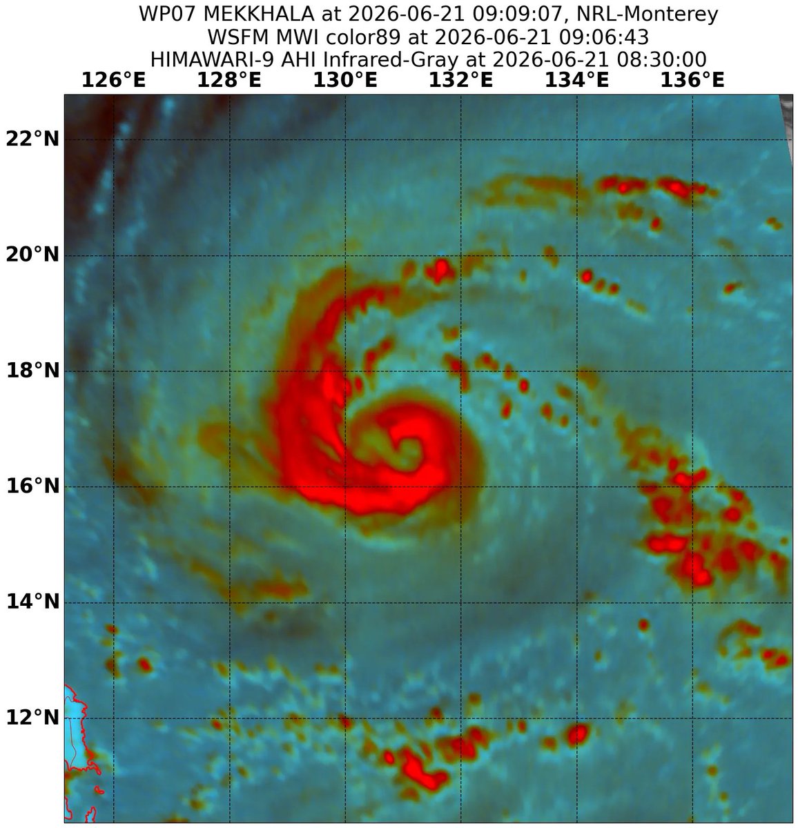
The eyewall begins to form in the center of Severe Tropical Storm #Mekkhala (#FranciscoPH). The latest 85 – 92 GHz imagery suggests that the inner core is trying to establish in the last six hours as the center becomes vertically aligned, signaling the start of a more rapidly increase in the wind intensity.
The real-time imagery shows a continuous intense convective hot towers reaching -90°C — with the convection becomes tightly wrapped around the center, suggesting the formation of an eyewall.
Based on the recent model runs, a rapid intensification (RI) phase may commence tonight or tomorrow early morning during the diurnal maximum, which could help the system to consolidate and strengthen further.
Some of the DVORAK identifiers have already assessed Mekkhala as a typhoon, but the official intensity from the agencies will be determined later in their respective advisories.
📷: CyclonicWX, NRL
#Mekkhala has formed, and looks quite healthy. The system is poised for a round of very rapid intensification in the coming days. For now though, Mekkhala is organized well, but not bombing out yet.
Tropical Storm Mekkhala is getting its act together really fast and conditions do favor intensification with low shear and decent relative humidity values 60% and higher. Mekkhala should be a typhoon by tomorrow, if not later today.
BREAKING: #Mekkhala has entered the Philippine Area of Responsibility (PAR) and was given its local name #FranciscoPH by the DOST-PAGASA. It also has intensified into a SEVERE TROPICAL STORM.
STS Francisco is the sixth-named storm within PAR this year and the second for the month of June — after TD #EsterPH. We now have the highest number of tropical cyclones in year-to-date this decade, and the highest for June in four years.
Based on the latest forecast track, the system will continue to move generally west-northwestward over the next two days before decelerate and make a recurve scenario starting Tuesday, June 23. In terms of intensity, it may reach typhoon intensity tomorrow, June 21.
Due to a favorable environment, a rapid intensification is not ruled out within the next 24 hours, while the system is meandering the Philippine Sea. So far, it is NOT expected to reach "super typhoon" category — in PH scale.
As the storm could make a close approach in the Extreme Northern Luzon on Tuesday, raising of Tropical Cyclone Wind Signals in the area are likely. A landfall scenario in the Philippines is still low chance, but a high chance in the southern Ryukyu Islands.
Everyone is encouraged to keep monitoring for the official updates from PAGASA (Philippines), CWA (Taiwan) and JMA (Japan; particularly in the Ryukyu Islands).
📷: PAGASA









![MattWestPacWX's tweet photo. Typhoon #FranciscoPH (#Mekkhala) continues to intensify, as the overall environment remains conducive for additional intensification — with very warm sea-surface temperatures (SSTs), and strong radial outflow. A rapid intensification (RI) is expected to commence in the next few hours.
As of 8:00 PM (12Z), June 21, 2026.
PAGASA: 130 km/h (70 kts) [10-min]
JMA: 130 km/h (70 kts) [10-min]
JTWC: 140 km/h (75 kts) [1-min] {Category 1}
The movement of the storm is being steered by the subtropical ridge (HPA) to the north — hence, a generally west-northwestward track. This will continue until Wednesday, June 24, before turning poleward as the HPA weakens due to a passing trough from China.
There has been no change in the forecast intensity — with the JTWC predicts a peak of equivalent to a Category 4 typhoon in the US scale, while PAGASA and JMA at 165 km/h, and 155 km/h, respectively.
Note: Landfall in the Philippines is UNLIKELY.
HOWEVER, the Southwest Monsoon (#HabagatPH) being enhanced by TY Francisco will bring heavy rains in some parts of the western portions of Luzon and Visayas beginning tomorrow, June 22.
📷: Himawari-9 via NRL-Monterey, JMA via WNJP](https://pbs.twimg.com/media/HLWAflQaIAAlPI9.png)