There is a level 3 risk of severe weather today stretching from central Nebraska into western Iowa today, with a much broader level 2 risk that covers much of the northern and central Plains.
Scattered thunderstorms are expected to develop this afternoon amidst moderate to strong instability and steep lapse rates, where supercells near the Black Hills/central Dakotas could drop very large hail (potentially >2" in diameter) and damaging winds. Heading into the evening, a low-level jet will strengthen allowing for these storms to grow upscale into organized bowing clusters, creating a significant wind threat for Nebraska/western Iowa, where winds could gust in excess of 75mph. Further south, isolated supercells could develop near a dryline, although poses a lesser threat of large hail and damaging winds due to forcing being less compared to Nebraska/Iowa.
Further east, from the Great Lakes to the Northeast, widely scattered thunderstorms are expected to fire from residual outflow boundaries left behind by last night's activity. Shear is weak in these areas, but a moist air mass with decent instability will allow for a few multicellular clusters to produce swaths of damaging winds.
Severe weather cannot be ruled out into the Tennessee Valley, where despite no wind flow, there will yet again be a moist air mass which combined with instability will allow for some isolated downbursts capable of producing some damaging winds.
Another day of extreme heat is expected across much of the eastern half of the country, where daytime highs will exceed 90s for most with 100s once again expected across much of the coastal Mid-Atlantic and Northeast. In addition to the heat, humidity will once again play a role, allowing for a widespread swath of heat indices in the 100s, with 110+ values once again expected across the Mid-Atlantic.
Impressively, the National Blend of Models (NBM) has uptrended for Maryland and Virginia, where there could be spots that get between 115-120 for a heat index! This is super dangerous heat, and Extreme Heat Warnings are once again in effect for most.
Remember it takes just 10 to 15 minutes in these conditions before heat stress is possible, and not much longer before it can escalate to heat stroke. Avoid strenuous activities outside, and if you must venture out, remember to stay hydrated! Only two more days of this level of heat left before things cool down somewhat...
Supercells that fire across portions of southern South Dakota, central and eastern Nebraska, and western Iowa will carry an isolated threat of dropping a tornado or two, before they congeal into organized bowing clusters by evening. The primary threat in this area will be very large hail potentially greater than 2" in diameter as well as damaging wind gusts over 70mph with some storms.
Over 50 million people are in a level 2 risk of severe weather for Independence Day, one area stretching from the Allegheny Plateau into the Mid-Atlantic, the other in the central Plains.
A weak frontal boundary will sag southward across the Mid-Atlantic, and with destabilization occurring over very hot temperatures, thunderstorms will likely ignite over the Alleghany Plateau. These storms will make their way east across, where there is the possibility of one or two organized clusters forming. These will carry the primary threat of damaging winds, so be sure to secure your trampolines so that they aren't the projectiles being sent upwards.
Meanwhile in the Plains, think of the setup as one of those store bought fireworks from Costco waiting for someone to spark it. Scattered thunderstorms, including a few supercells are expected to develop by early evening. These will be capable of producing large hail, severe winds, and maybe a brief spin-up before a low-level jet feeds these storms further, allowing for a large, organized cluster to develop tracking southeastwards later in the evening.
ITS HERE🚨🚨🚨
Hailinator merch is now LIVE in @MaxVelocityWX’s merch store! Thank you to his chat for the nickname and his team for the idea of this. Go check it out and maybe get yourself a shirt!
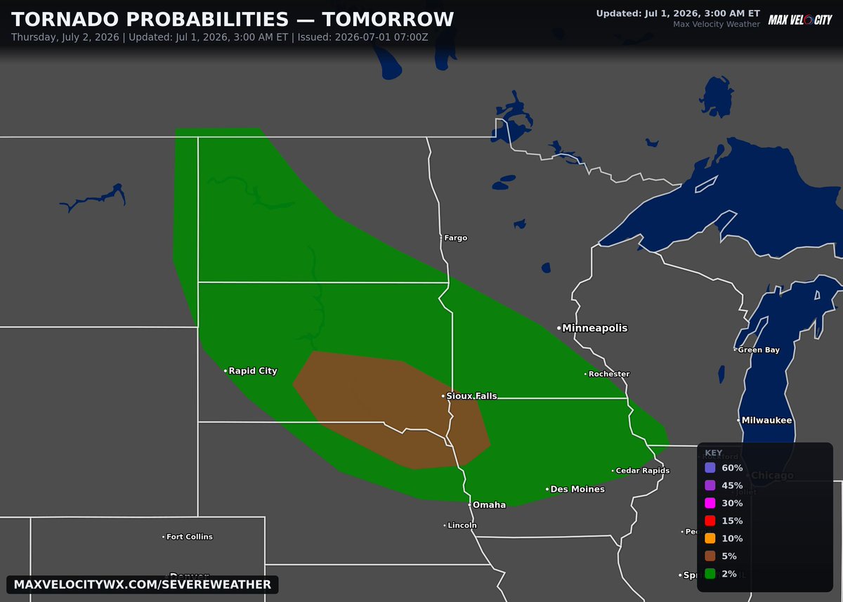
The best chance of tornadoes tomorrow will be focused over southeastern South Dakota, northeastern Nebraska, and western Iowa (particularly I-90 vicinity and south), where initial supercells that develop could drop a couple of tornadoes before storms congeal into a storm complex capable of bringing damaging wind gusts over 75mph as the primary threat. A tornado or two cannot be ruled out from the North Dakota/Montana border all the way to the Iowa/Illinois border.
There is a level 2 risk of severe weather on Friday for southern South Dakota and northern Nebraska, where thunderstorms are expected to develop along a residual outflow boundary left behind by Thursday's storm complex. There remains uncertainty as the current region assumes that storms forming north should remain elevated atop cooler, more stable air. However, if there is further destabilization than currently expected, the risk area could be adjusted in later updates to include more of South Dakota.
Elsewhere, we have a MASSIVE area under a level 1 risk that alone has over 100 million people under it. Of course, there is probably zero surprise at this point the Midwest is once again involved, and that once again, there will be morning thunderstorms migrating out of the Missouri Valley. With this being a repetitive pattern that keeps hinging on previous activity, this being 2 days out means models still have heavy disagreement on how this activity will evolve. The southern portion of the risk would have better chances of severe weather if the storm complex is strong during the morning hours, pushing the favorable airmass south, while others keep it north. Once there is confidence on which scenario will unfold, a level 2 will likely be introduced as we get closer to Friday.
Further east into the Ohio Valley and Mid-Atlantic, an unstable airmass will lead to the beginning of what could be several days of thunderstorm chances for these areas. While shear on Friday will be weaker in comparison to the areas mentioned above, these isolated, disorganized storms will still present a localized threat of damaging downburst winds with any pulse cell that can establish itself.
After a lot of thought, I have decided to make a bot called "MaxBot".
It will mispronounce every single town name on stream and desperately be searching for a girlfriend.
You're welcome.
Approximately 110 million people are under threat for severe storms today from Billings, MT to NYC. A three headed slight risk is in place. One for the Central high plains where giant hail and isolated tornadoes are possible from supercells growing into li ear clusters later on today.
Wind is a much bigger threat for the eastern half of the risk, including the small sliver of slight risk in Texas and Arkansas. Two small areas of tornado potential exist. One from South TN, northern Mississippi and northern Alabama and another in the northeast including Maryland, all of New Jersey and east Pennsylvania. Today shouldn’t be nearly as busy tornado-wise as yesterday was!
The best chance of seeing a tornado today will be in Washington DC, Philadelphia, and Huntsville...
A few tornadoes will be possible, mainly during the mid-late afternoon and early evening.
More severe storms are likely in the Great Plains tomorrow, mainly centered from Denver to just north of OKC. There, potential for significant severe wind and severe hail exists from afternoon storms. Tornado potential will be concentrated around Cheyenne and Denver where a small 2% has been issued. Supercells are possible in this area before they congeal into messy segments capable of significant wind primarily.
When looking at tornado reports so far for 2026, one state in particular stands out.
Illinois has a total of 196 tornado reports right now, which blows its previous record of 139 set in 2024 out of the water. This also destroys the annual average number of tornado reports which sits at 54.
More tornadoes are likely to be confirmed across the next few days which will likely push this number over 200, and it’s only June 😳 .
As a country, the US is currently above average for this time of year on tornado reports, despite a relatively quiet year in the plains. This is because of the Midwest and especially Illinois having so much tornado activity.
The active season is likely to continue through the summer as we approach a typically active timeframe for severe weather in the Midwest. Illinois may see more severe storms beginning late this week. Attached is the tornado probability forecast verification for yesterday. We could have verified much higher probabilities! Maps via SPC