Check out our latest research: Wildfire risk for global wildland–urban interface areas | Nature Sustainability@HKUniversity @HKUgeography @WShengbiao @jin_yufang @marssong0210 thanks to all wonderful coauthors. https://t.co/0Q3CtRj2e9
In just 40 years, China went from a predominantly rural society to a highly urbanised one. What happened? And what lessons can other urbanising regions around the globe draw from that experience?
#HKU Professor of landscape architecture Bin Chen believes we can find the answers in satellite data. An expert in remote sensing and Director of HKU’s Future Urbanity and Sustainable Environment (FUSE) lab, he’s using satellite imagery to track everything from the historical growth of cities to emerging problem areas like urban heat, air pollution, and green/blue space loss.
It’s a cutting-edge field – and one with implications far beyond China. Done correctly, it could provide one of the first-ever windows into how cities grow and evolve in the real world. This emerging “urban intelligence” will in turn have major ramifications for rapidly urbanising countries across the Global South, allowing them to avoid mistakes made by other cities while empowering them to create more equitable built environments for all residents.
We asked Professor Chen to share his thoughts on the nature of his work, the importance of remote sensing and AI to urban planning, and how the world can build more equitable cities.
#AI #sustainability
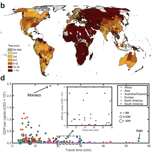
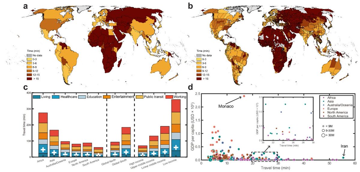
The "15 minute city" has become a buzzword in urban planning.
But how many people actually live within 15 minutes of essential services?
Researchers have now mapped this for every person on Earth.
Here's what they found:
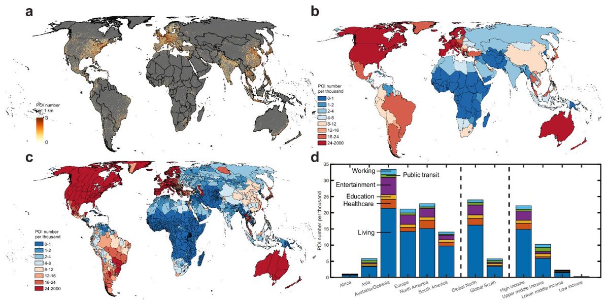
Our latest @NatureComms paper: Measuring global human accessibility to essential daily necessities and services. We compiled a global database of essential infrastructure and assessed human access to those daily essentials. @HKUniversity@HKUgeography https://t.co/aGGrHvgsL8
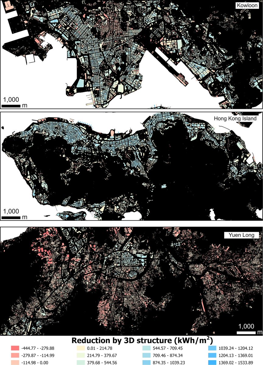
Our new Landscape and Urban Planning paper #urbanPV#3Dmodeling led by my PhD student @HanwGeek High-resolution 3D solar potential assessment reveals significant shading-driven overestimation in dense urban areas: 17.6% overestimate in HK. Read the paper: https://t.co/JNhfHLvdUp
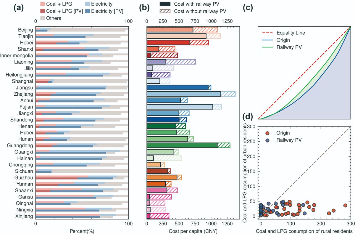
China’s extensive railway network with suitable PV deployment could potentially generate 204.6 TWh of electricity annually, equivalent to more than twice of the Three Gorges Power Station’s output, accounting for ~9.2% of China’s total renewable electricity generation in 2020.
Check out our latest research on #railway#PVpotential led by my PhD student @HanwGeek China’s railway photovoltaic potential for sustainable urban–rural energy transition https://t.co/uVbi7gqls2 via @IOPenvironment
Check out our latest research on #railway#PVpotential led by my PhD student @HanwGeek China’s railway photovoltaic potential for sustainable urban–rural energy transition https://t.co/uVbi7gqls2 via @IOPenvironment
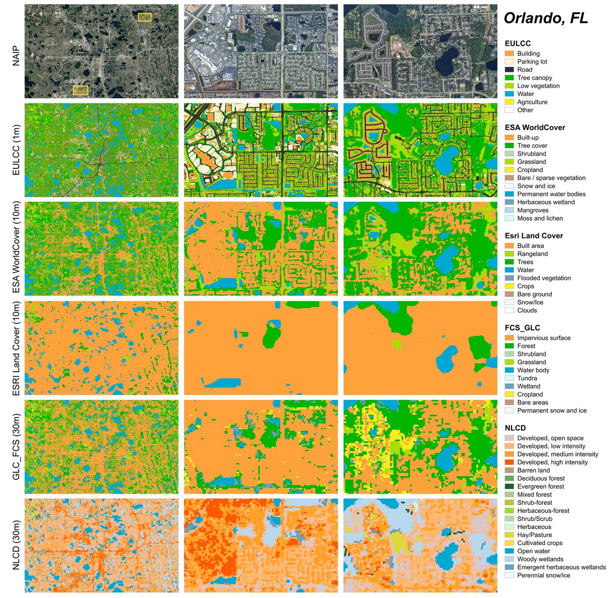
📝Check out our new #TGRS paper: Large-scale High-resolution Essential Urban Land Cover Category Mapping Using a Semantic-Augmented and Noise-Tolerant Approach.
🗺️New data: 1-m essential urban land cover category (EULCC) mapping for all US urban areas.
https://t.co/7tEGKxwpfx
Enhanced mapping of essential urban land use categories in China (EULUC-China 2.0): integrating multimodal deep learning with multisource geospatial data https://t.co/28P1mAJOIj
#Geo#EarthSciences
Excited to share our latest study in @NatureHumBehav. We examine infrastructure through economic, social, and environmental lenses, uncovering significant inequalities in access and their associations with health outcomes. Grateful to work with such an incredible team!
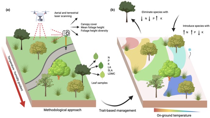
Right trees are key for cooling! 🌳
By "Inventory + LiDAR" for 4000 trees in #Shanghai, we found leaf traits (N, P, K) > canopy structure for cooling.
@JAppliedEcology
➡️https://t.co/YAf5zttqwX
HUGE thanks to @Javier_Lopatin for Research Highlight🙌
➡️https://t.co/JVMLHzKJeM
Check out our @Sci_Bull paper: Enhanced mapping of essential urban land use categories in China (EULUC-China 2.0): integrating multimodal deep learning with multisource geospatial data. EULUC-China 2.0 data download: https://t.co/QFd50MMriS https://t.co/gTQgI5yfSQ
Check out our new paper led by Jiafu. Impact of women’s political empowerment through gender quotas on improved drinking water access in Africa | PNAS https://t.co/d3cf4K3A9x
The HKU President’s Office is inviting nominations for Presidential Research Assistant Professor (RAP) Scheme (very competitive package). Feel free to reach out if you are interested in working with me and FUSE Lab on remote sensing for sustainable environment.
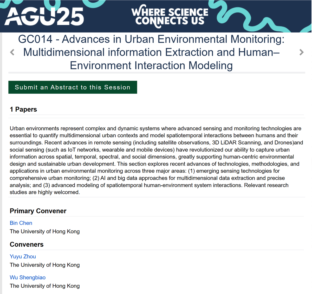
#AGU2025 Call For Abstracts
Consider submitting your abstract to our #UrbanFocus Session at the AGU Fall Meeting 2025 (Dec 15-19, New Orleans)—"GC014 - Advances in Urban Environmental Monitoring: Multidimensional information Extraction and Human–Environment Interaction Modeling"