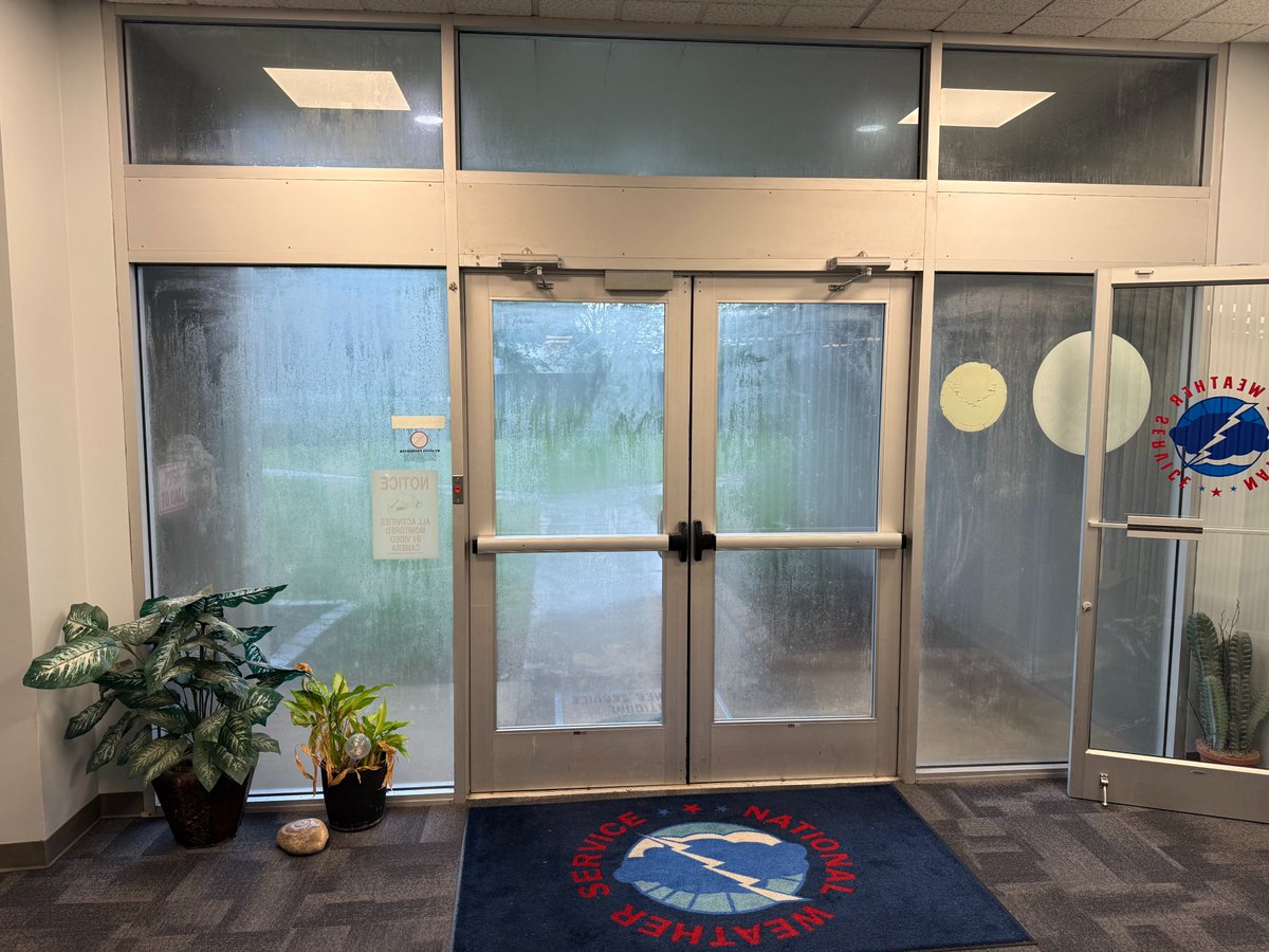
Keep in mind 40,000 people are watching the Savannah Bananas across the street, and 1/3 of the state is on a lake right now.
Lynx crowd still likely pushing 12,000 today.
Wow!
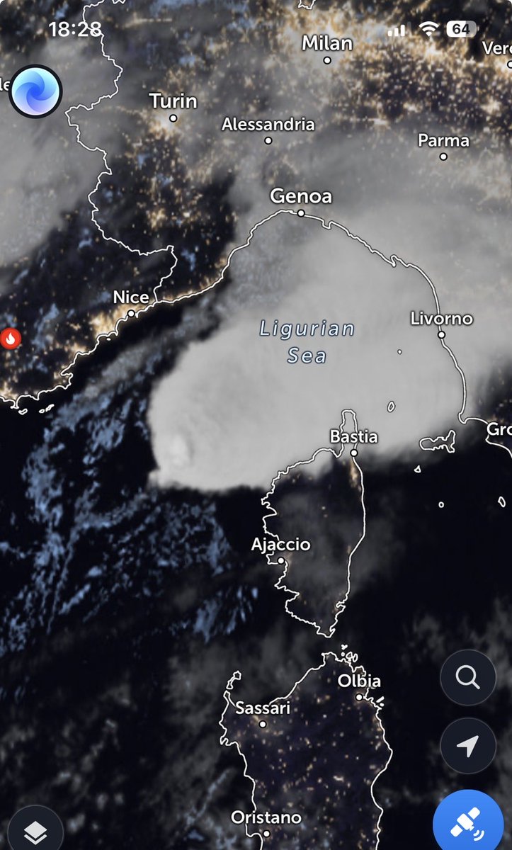
Here’s the real footage of that Mediterranean lightning bomb⚡️⚡️
📍The same rare, high-end supercell we tracked on radar last night near Corsica.
🌀 A classic mesocyclone with 59-knot VROT and extreme lightning activity…
This video is not sped up.
-It’s producing more than one flash per second. Look at the continuously illuminated core. Intense electrical activity is lighting the storm from the inside.
🛰️This is the visual confirmation of what the radar data showed.
#Supercell #Tornado #Waterspout #Lightning #SevereWeather #Mediterranean #StormChaser #Weather
This one hits like a gut punch:
Austin Sarat, my favorite college professor, pens a fierce OpEd on @AmherstCollege students’ inability to read challenging texts.
He rightly pins blame on “a K-12 system that has quietly stopped asking them to finish books at all.”
“This past term, I enlisted a few colleagues to teach a short course called “Why Read?” We spent three weeks working through essays on the value of reading by scholars like Martha Nussbaum and Edward Said. What struck me wasn’t students’ lack of interest — it was how unevenly prepared they were even to attempt something long and difficult.
It was clear to me that the students had very different approaches to and comfort with reading difficult material. I tried to help them see that when it comes to reading, similar to physical exercise, the most benefit comes with the most exertion. Reading longer things requires patience and attentiveness, it cultivates the capacity to follow an argument or a plot, and it requires sustained effort to decode meanings.
Surely, this single course won’t end students’ entrenched habits and reverse their retreat from reading. But before we ask our students to read difficult material, those of us who teach in college owe it to all of them to explain that reading books in their entirety matters. If we won’t, or can’t, then higher education will have a bleak future.”
This new study finds that the total death toll in Europe during the June heatwave exceeds 20,000 people.
"This result highlights the accelerating threat of mass heat mortality events in Europe despite previous adaptations to heat." Pre-print here: https://t.co/mCIy4nOuHj
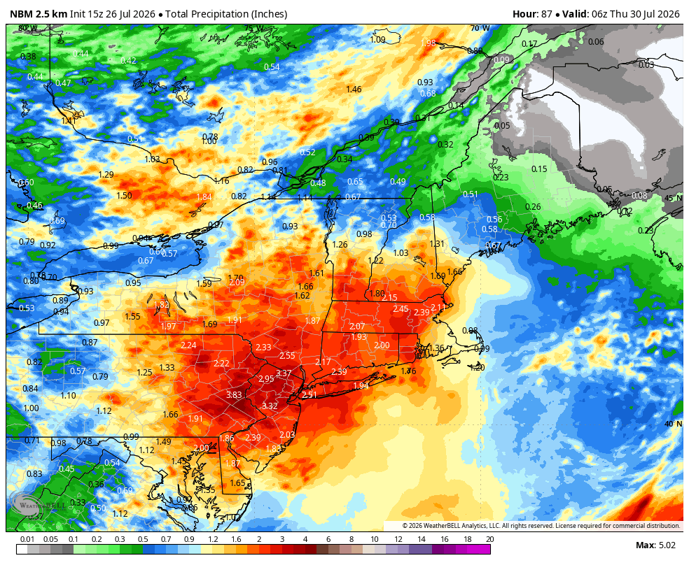
RARE SUMMER NOR'EASTER: July 28-30, 2026
Fascinating progression this week: a fast moving shortwave atop our ridge will eventually become a legit Nor'easter off the Atlantic coast, spearheaded by blocking to the north. This will be a slow moving storm that brings a good soaking!
Les 24 dernières heures en 45 secondes. Les avions tournent sans relâche jusqu'au coucher du soleil, puis plus rien : ils ne volent pas de nuit.
Depuis 22h il bruine sur la zone, l'air est à 90 % d'humidité. Une nuit un peu plus clémente.
Faites tourner. #FireWatchArcachon
It was a record setting 52° July 27, 1962
that record went down today
47° Bedford MA this morning makes it
the coldest July 27th sunrise ~ ever ~ in our life.
4th day in a row record cold in northeastern 🇺🇸
According to MN State Climo Office, prior to today, there have only been 28 hours with 80 degree dew points measured in the Twin Cities since 1945. Last night and this morning we added another SIX!
My goodness. Never seen anything quite like this just now on French news @le20hfrancetele
A quarter of a million people forced to leave their homes. Firemen exhausted in the unequal fight. Huge area around Bordeaux engulfed in flames
Please give it a watch
My Eng subtitles
🌎⛏️Advance orders are OPEN for the 2026 #EarthScienceWeek Toolkit!
Explore “Critical Minerals for a Thriving Society” with posters, a resource calendar & digital learning materials.
📦Ships late August.
👉 https://t.co/dqnMRO3S65
#AmericanGeosciences#CriticalMinerals
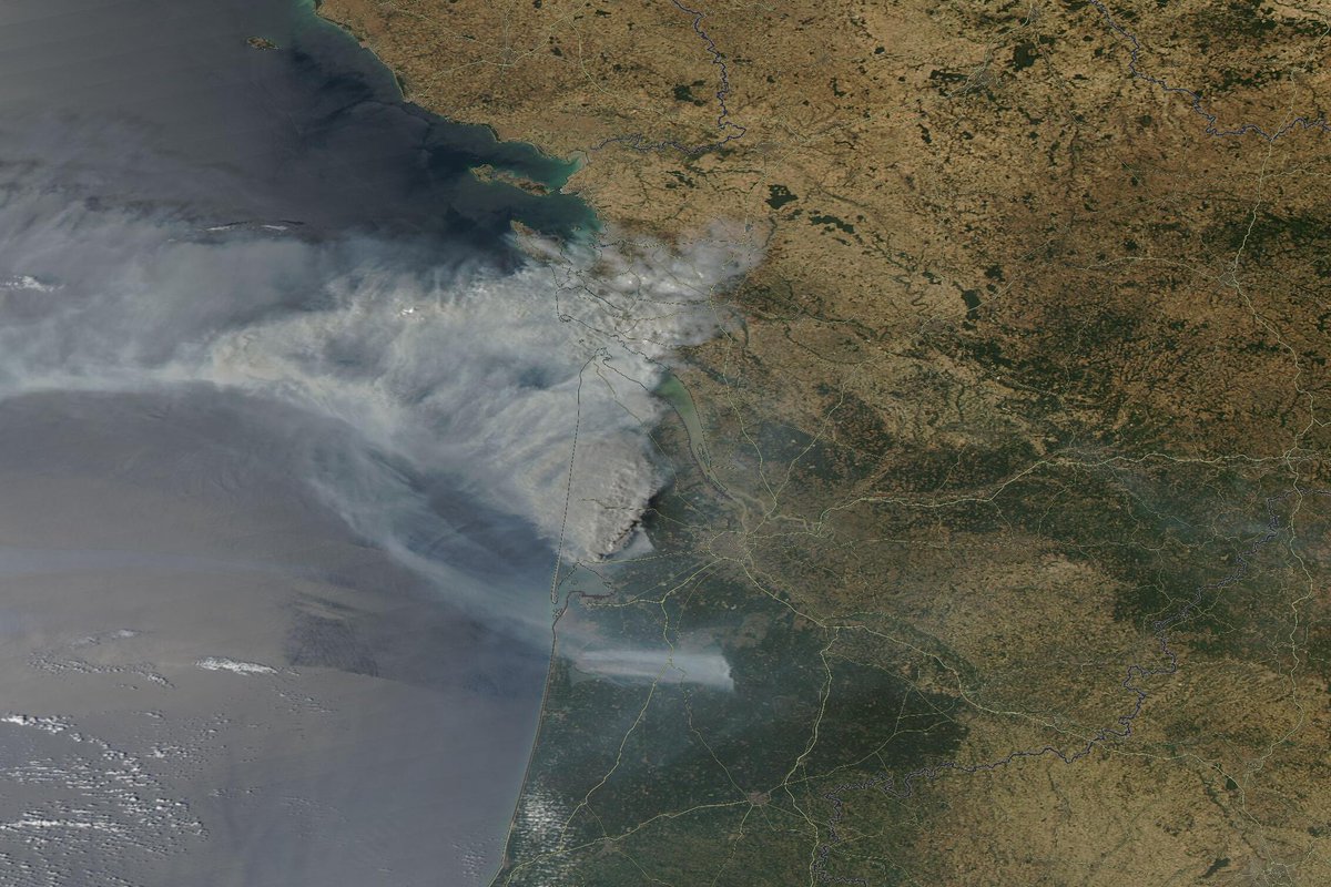
Le feu de Gironde présente désormais toutes les caractéristiques d'un méga-feu, à commencer par la formation d'un pyrocumulonimbus. Ce gigantesque nuage entretenu par la convection du feu permet à l'incendie de générer son propre micro-climat, avec des flux de vent qui entretiennent et intensifient le brasier.
Cette spectaculaire image satellite AQUA/MODIS du 24 juillet l'illustre parfaitement. Elle montre non seulement l'impressionnant pyrocumulonimbus au-dessus de l'incendie, mais aussi une France largement jaunie par une sécheresse d'une intensité inédite pour une fin juillet depuis le début des relevés.
#Incendiesdeforêt #incendies #Gironde #Lacanau
Il y a trois jours, j’avais publié un message que j’ai finalement supprimé. Je le trouvais trop émotionnel, et pas assez solide face aux incertitudes sur l’intensité de cette troisième canicule. J’ai eu tort.
Les modèles convergent désormais clairement vers une nouvelle canicule durable et exceptionnelle.
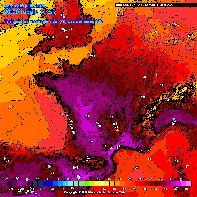
Le scénario de juin 2026 se reproduit : une goutte froide au large du Maroc, une masse d’air brûlante remontant du sud, et un blocage sous un dôme de chaleur. Des températures supérieures à 40°C pendant plusieurs jours, correspondant à un niveau de vigilance rouge, sont à nouveau très probables sur un large quart sud-ouest. Copier-coller.
Cette fois-ci, je ne veux plus masquer mon inquiétude. Ce qui se profile est une catastrophe pour nos écosystèmes. Dans un contexte de sécheresse déjà extrême, les impacts vont s’accumuler : mortalité, brûlures, avortement floral, arrêt de croissance, défaillance des cultures. On repart sur les mêmes bases qu’en juin. Et, très honnêtement, les bras m’en tombent.
This marvellous interactive tool tells you where any passport can take you. This is based on live data too. Really cool website. Make sure to check it out: https://t.co/apwdNbacMa
PSA that whatever happens over the next 24 hours, space weather is HARD to forecast. Our CME could certainly impact tonight, or it could hit near sunrise or even during the day on Monday!
All of these scenarios are possible because forecasts have uncertainty that is rarely talked about by the news/media. On average, solar storm models have a +/- 7 hr uncertainty, so it's good practice to treat impact times with a grain of salt.
And, there is no one to blame for this. With our current fleet of satellites measuring the Sun and the solar wind, there are only a certain number of data points we can use to create a forecast, and the models forecasters use to issue predictions are ran quickly so that the required stakeholders get advance warning as early as possible.
Also, agencies like NOAA SWPC are not forecasting space weather for you, me, or any other aurora chaser. I am sure they would like to, but keeping the United States and its assets safe is the first priority--like making sure satellite operators know what kind of radiation doses their spacecraft might experience or modeling geomagnetically-induced currents in the ground so power grids can mitigate any blackout risks. What the aurora will do and who will see it is close to if not at the very bottom of the list for SWPC, which is totally fine. It just means we have to do a little interpretation of the official forecast products on our own to understand what the aurora may do.
Finally, while there are certainly some stations not acting entirely in good faith, most meteorologists are doing their best when it comes to reporting space weather. The majority are not trained in the topics or have the most optimized and scientifically-accurate graphics ready to go for every situation. Meteorologists will be critical partners and allies as we, as a community, work to bring more awareness to how to "chase wisely" and understand aurora science better.
I just wanted to get this out since over the last 2-3 days, a lot of people have been blaming mets, SWPC, me, other creators, etc. for wrong forecasts or for things not panning out exactly how they wanted. The reality is that forecasts not verifying 100% happens in regular meteorology all the time, we are just used to that. The same is true in space weather, but it's 5-10x worse--our tech is at the 1970s-level of current terrestrial meteorology and weather forecasting. Just because a CME didn't arrive right when you wanted it to does not mean anyone was being deceitful or acting without the best interests. Space weather just "does what it does," and sometimes it acts in mysterious ways.
This has to be *one* of the more abysmal drought monitor maps we've seen across the US in some time.
Every state is experiencing at least some form of drought. While we have seen years with pretty severe and expansive drought areas, seeing this much of the US in drought isn't good. The Intermountain West and the Southern U.S. are particularly struggling.
We need water, folks!
🐦 🐦 Last night, millions of birds were on the move north and northeast across the Mid-Atlantic and adjacent regions. Across the whole Lower 48, it is estimated that 100 million birds were migrating. The highest concentrations were in western parts of the Mid-Atlantic into the Ohio Valley, the Southeast, and southern Plains.
The map here — BirdCast, from Cornell Lab of Ornithology — shows where nocturnal bird migration is happening, as detected by Doppler radars across the country.
It shows how many birds are in flight and which direction they are headed. Warmer colors are where bird migration is the highest. The colors indicate only birds in flight, so numbers are typically higher when considering those on the ground.
The forecast calls for significant migration to continue through the weekend.