11/17 940PM - A number of Flash Flood Warnings remain in effect across Northern Miami Dade and Broward County this evening shown in the green boxes.
These cells are capable of dropping significant amounts of rain in very short periods of time.
11/17 845PM - Very heavy rainfall occurring across portions of NE Miami Dade and SE Broward County with this cell anchored along the coast. Radar estimates rainfall of 3-5” in the last hour alone.
A Flash Flood Warning remains in effect for the area through 10:15 PM ( green box)
The Flood Watch has been expanded southward to include all of Southeast Florida through Thursday evening.
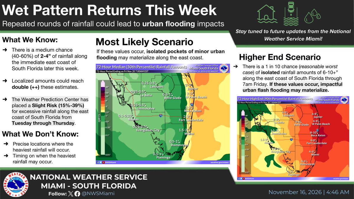
Periods of heavy rainfall will be possible over the next few days which could lead to isolated areas of significant urban flooding.
Multiple hazards for the mid-week period:
🌧️ Heavy rain could lead to urban flooding concerns along eastern South Florida. A Flood Watch is out for metro Palm Beach.
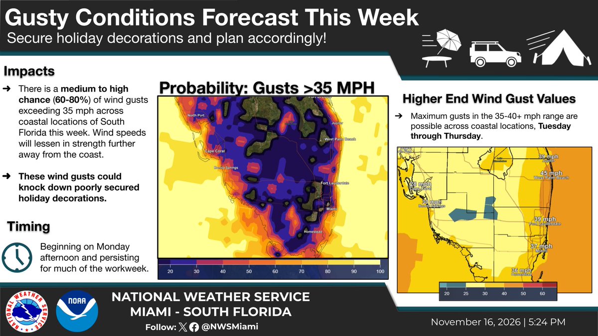
🌊Dangerous seas and gusty conditions along Atlantic waters and beaches. 30 mph wind gusts and 7-9 ft seas.
#flwx
11/15 @ 10 PM: Heads up, South Florida 📢
- An increased urban flood risk returns along the east coast during the middle of the workweek. 🚨
- Stay tuned to the latest forecast over the next several days, as details on 1) timing and 2) rainfall totals can and likely will change.
In case you heard otherwise, there is no radar outage and https://t.co/sKhgAVX4eI is fully operational! Outdated content from isolated webpages stating otherwise has been circulating, but NWS radars are operating normally.
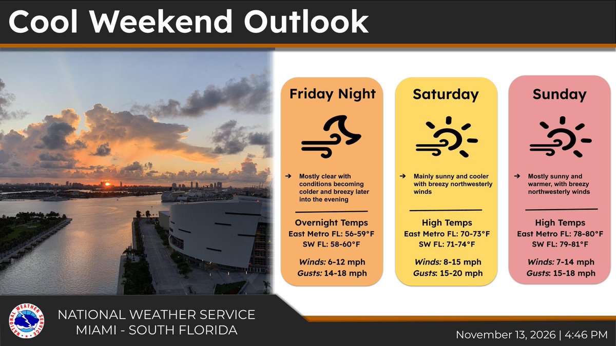
Cooler temperatures and breezier conditions expected this weekend! High temps should stay in the mid to low 70s while low temps could dip down into the upper 50s for some areas. Mostly clear and sunny skies will make for a pleasant start to fall, so make the most of it! #flwx
There are several resources available for tracking rainfall across Florida this winter!
- Observed Rainfall and Percent of Normal maps (available at https://t.co/puecd1lNbI)
- SERFC Accumulated Rainfall Trackers
#Day3#FloridaElNiñoAwarenessWeek
South Florida averages more heavy rain days (2"+) during El Niño winters, however not every El Niño is the same.
Flooding can happen in any phase; 1 heavy-rain setup is all it takes. There have only been 9 Strong El Niño winters since 1950.
#Day3#FloridaElNiñoAwarenessWeek
Strong El Niño winters see about 3x more *total* severe weather reports than neutral winters here in South Florida.
Note: Severe weather can happen in any winter. El Niño raises the odds but it doesn't guarantee the outcome.
#Day2#FloridaElNiñoAwarenessWeek
We’re excited to announce the hiring of Jeff Purinton as Vice President and Director of Athletics!
A two-time FSU graduate, Purinton returns home after more than 30 years of leadership experience across collegiate athletics. Read more here: https://t.co/xagxWus6rJ
Welcome back to FSU, Jeff! 🍢
Warmer sea surface temperatures in the equatorial Pacific result in a subtropical jet stream displaced further south across the southeast U.S.
El Niño affects average weather patterns and event likelihoods; it is not a *guarantee* of impacts.
#Day1#FloridaElNiñoAwarenessWeek
Florida El Niño Awareness Week is this week! 🚨🌩️
@NWS@NWSCPC@NWSWPC
Here is a list of daily topics:
Monday, Nov 9 - El Niño Overview 📚
Tuesday, Nov 10 - Severe Weather Impacts 🌪️
Thursday, Nov 11- Flooding Impacts 🌧️
Friday, Nov 12 - Winter Weather Impacts 🥶
Do you know what potential impacts a Very Strong El Niño could bring to South Florida? Tune in next week as we begin #FloridaElNiñoAwarenessWeek!
It will be packed with facts & information about potential impacts we could see locally this winter.
Be prepared, not scared! 🤝
💪 Fighting the floods.
📹 The @SFWMD is actively pumping water away from people into a reservoir.
🤝 The District remains actively engaged with our partners to mitigate flood impacts while monitoring progress.
💦 We continue to focus on moving flood waters away from communities in St. Lucie County. Our EOC is at Level 2 and our crews are pumping water, conducting field assessments and sharing technical data.
🥾 We are continuing to provide boots on the ground assistance to impacted communities and will continue until the job is done.
A benign weather pattern continues overnight with mostly clear skies and mild temperatures across South Florida. Along the Atlantic coastline, elevated astronomical tides will maintain a risk for localized minor coastal flooding heading into the weekend. #flwx
Overnight, significant rainfall and flash flooding in McCaysville, GA, and Copperhill, TN, caused a historic rise in water levels on the Toccoa/Ocoee River between Blue Ridge Dam and Ocoee No. 3 Dam. Beginning at 7 a.m., we stopped all releases from Blue Ridge Dam to limit additional downstream flows.
Our crews at the Ocoee Dams and the River Forecast Center are closely monitoring the dams and water levels as they manage the massive flows downstream. For local information and directions, follow the local emergency management agencies in Fannin County, GA, and Polk County, TN.