Meteorologist for NBC4 in DC. Oklahoma Alumnus, International Traveler, Marathon Runner. Lover of Dogs, Old Cars, History, Trivia, Cooking and My Husband.
* We declare spring over and summer underway in DC *
Pack away your jackets and break out the bathing suits, sunscreen, and hats.
We declare spring over and summer underway.
The transition happened quickly. The tail end of May and opening days of June offered one last taste of spring, with highs mostly in the 70s and crisp morning lows in the 40s and 50s. But summerlike weather has now taken hold.
Temperatures soared into the 80s on Wednesday and Thursday, and forecast highs are expected to remain in the 80s and 90s for at least the next two weeks.
Photo by Jeanne Stuart McVey
COG forecasts Code Orange air quality for the D.C. region tomorrow due to ground-level ozone pollution. Stay air quality aware and learn tips to clean the air: https://t.co/vujQarGehK
THIS GUY LIVES UNDER SFO'S TAKEOFF PATH SO HE BUILT A CEILING PROJECTOR THAT TRACKS EVERY PLANE FLYING OVER HIS HOUSE IN REAL TIME
he uses a cheap $30 radio receiver to pick up the signals that planes broadcast while flying.
then projects them onto his ceiling in real time
when a jet flies over his house you hear it outside and at the exact same moment a plane glides across his ceiling labeled with the airline, aircraft type, and destination
pure black background so the projector's rectangle disappears and only the aircraft are visible
but he didn't stop at planes
it also draws the real sky behind them. sun, moon, bright stars, constellations, and live satellites including the ISS. all at their true positions for his exact location and time in real time
so he's lying in bed watching the actual night sky projected onto his ceiling with real planes crossing through it as they take off from SFO
there is a huge market for every man alive that runs outside to see the helicopter
vibe coded the whole thing himself with a cheap radio, a projector, and some clever software
This is something I have never seen before on satellite.
Clouds perfectly outlining roads.
Just incredibly neat imagery of Houston, Texas this morning.
Massive shoutout to @Emokwx who discovered it.
100% AGREE. Last year, June started out really cool: 48° at @Reagan_Airport on 6/1/2025 was the first <50° in June since 1972. 99° on 6/24/2025 was the hottest day of the whole year.
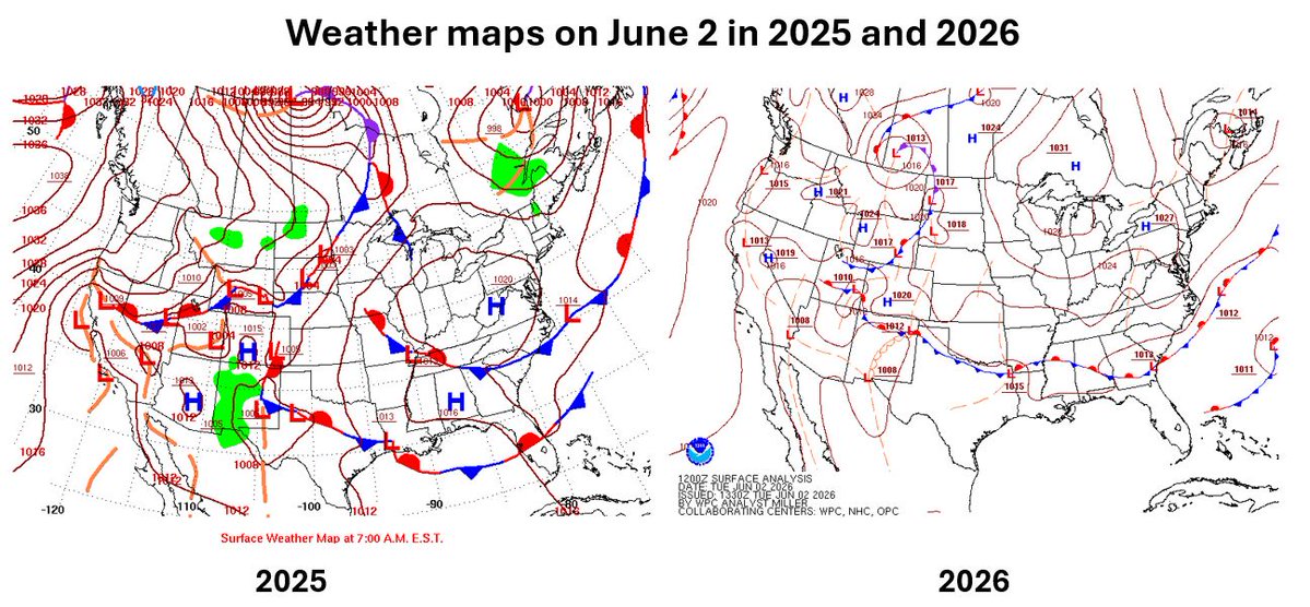
History repeats? This is odd and eerie.
The weather in DC on this day is almost EXACTLY the same as it was on June 2 last year: Sunny, cool start, mid-70s for highs.
What's even more uncanny is that the fronts and high and low pressure systems nationwide are mostly in the same place.
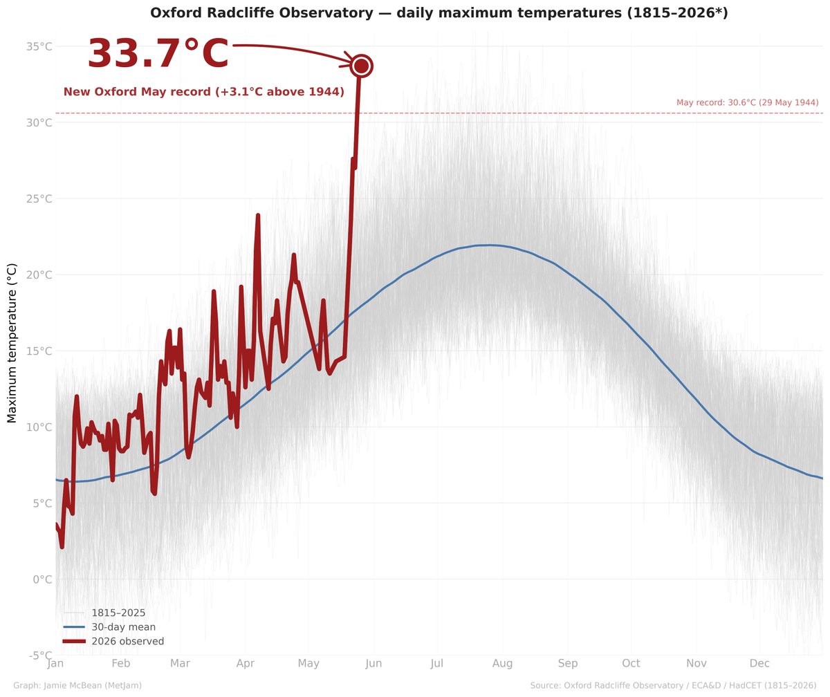
Oxford, the longest running continuous weather station in UK history, with temperature observations stretching back to 1815, has preliminarily broken its maximum temperature record for May yesterday by OVER 3ºC with a temperature of 33.7ºC. Unprecedented in its 211-year history.
Update. @nbcwashington is in #weatheralert until at least 8pm as developing storms near I-81 at 3pm will move towards metro DC. Stay with @dougkammerer for updates.
MiniCOW packs MegaPOWER! Observes birth and ingestion of satellite tornado
and Fujiwara effect deflecting tornado. Tornado transitions 2x between clear eye and debris ball. Prelim data from most powerful mobile radar, 1 MegaWatt C-band storm-penetrating miniCOW in Braman, OK 🌪️
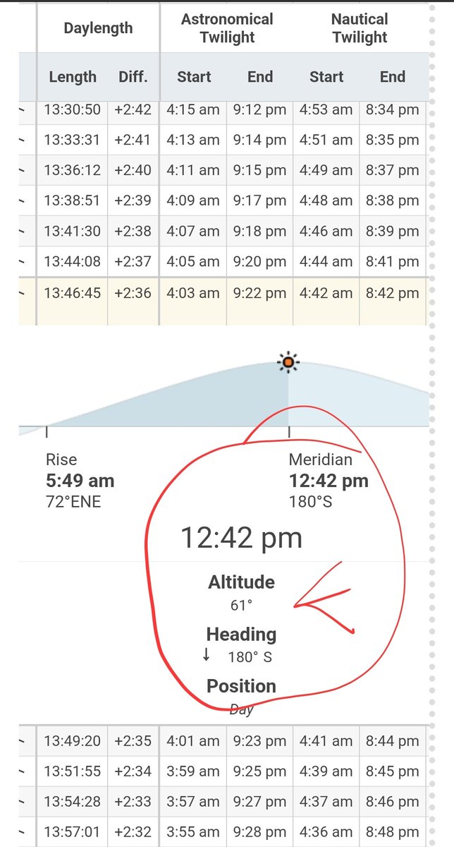
Here comes the peak height of the Sun for the day. This is about the same as August 18th. So sunscreen is definitely in order folks. Even if it's not hot the sun strength is the same.
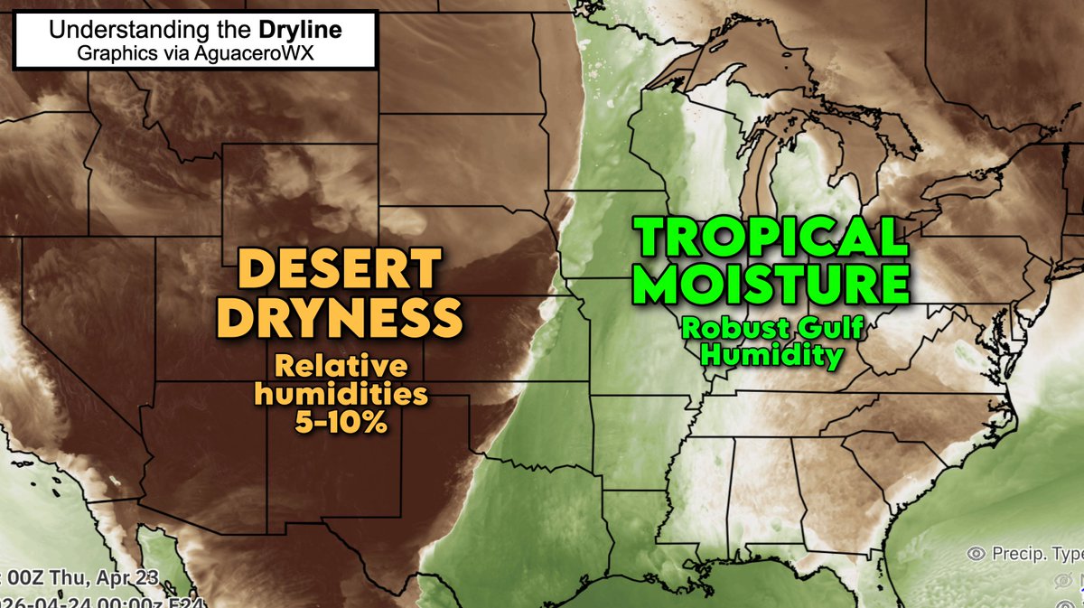
THE DRYLINE – no place in the world has a dryline as robust, sharp and impactful as we have in North America.
It's an extreme clash that exists on an order of miles. Tropical, Florida-like moisture juxtaposed against desert dryness.
In Oklahoma, a simple drive of 5 miles separates a Sahara-like airmass from rainforest-like moisture. Unless you've experienced it, it's hard to believe. Dew points will vary by 50 degrees in barely 8 miles!
The dryline is responsible for some of our nation's most dramatic weather. The clashing air masses routinely brew severe thunderstorms with tornadoes, baseball-sized hail and torrential rains. Like clockwork, rounds of violent storms crop up every April and May.
Unlike cold fronts, drylines don't bring dropping temperatures. It often stays warm or even gets HOTTER behind storms.
So how does the dryline work? Thunderstorms happen because the dry air is denser than moist air. Yes, really! Air is mostly nitrogen gas (N2), which weighs more per molecule than water vapor (water gas). So the more water in the air, the lighter the air is compared to dry air, which is mostly N2.
That's why the dry, dense air effectively impinges upon, and kicks up, pockets of moisture-laden air to the east. That often generates storms.
To date, our 3rd warmest Spring in 150 years of DC records. Mostly likely above 80° today and tomorrow, padding our lead of 80s so early in the year.
Our long term drought is also an issue. 4th driest on record from last Aug 1 ➡️ April 22 nearly 10" behind in rainfall.
Feeling the chill in the Northeast and Mid-Atlantic this morning?
Ten days ago, the air mass you're now experiencing was over Bray Island, Nunavut, Canada 🥶
It dipped to a record-tying 12 degrees at Saranac Lake, New York!
Cutting so many soundings from the EML source region has been disastrous for model data. Forecast verifications have been really bad lately. We really need something to give here…
Long term dryness expected to continue. Our drought issues began late last summer with the driest August on record (0.20”). The 1Aug thru 15April period has been the 4th driest on record! 9.56” below average @Reagan_Airport and 12.39” below @Dulles_Airport@capital_climate