Nova Scotian teenage amateur meteorologist. Running 2 weather stations. Passionate in all weather. Passionate in trains, transit and urban planning as well.
I'm thinking off changing over to Bluesky for my weather posts, as it is a much calmer and better environment overall. I will still likely make posts over here but for more frequent #NSwx posts, follow me on bluesky:
https://t.co/LrKkYxH6ux
#BlueskySocial
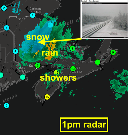
1pm update: The shift to cold NW winds has dropped temps: roads partly snow covered in parts central NB. The showers are now spreading into NS & PEI.
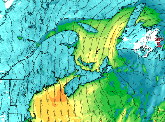
As cold air advances into S NB this aftn then PEI & NS this eve & overnight, risk of messy roads in parts S NB, PEI and N NS.
A cold and blustery day is in store today for all of Nova Scotia. Some flurries are forming off of the Gulf of St. Lawrence and giving a dry dusting to high elevations in the Cobequid Pass. Wind should die down in this evening, with a sunny and warmer day tomorrow. #NSstorm#NSwx
A raw, powerful wind is in store for the Fundy coast (including Margaretsville) tonight and through tomorrow. Northwest winds sustained up to 30 kt (55 km/h) off the water with EC calling for gusts up to 80 km/h!
#NSstorm#NSwx
Its a cool and breezy day for Nova Scotia today! Warm-up coming on Wednesday with a nice 19C forecast before plummeting again to 8C. Winter is coming! #nsstorm#nswx
What looks to be snow falling along Trunk 12 on the South Mountain of the Annapolis Valley, NS! Would be quite wet and slushy likely, not sticking to the ground either. First snow of the season! #NSstorm#NSwx#NSsnow@allistercanada
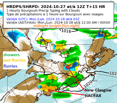
High-res model snapshot at midnight tonight (Sun night). Basically showery, breezy conditions and of course much cooler. Some spots will see wet snow showers (flurries) - even a few flakes around Halifax. #nswx Detailed forecasts: https://t.co/Qg5tZQuklt
Chance of some rain showers and flurries inland possible Sunday night to Monday Morning across the Maritimes! Nothing major though, likely wont even stick to the ground. #NSstorm#NSwx