This is a prolonged heatwave starting this week and intensifying next week. Temperatures running consistently above average and peaking over 10°C above average. Parts of France, Spain, and Portugal could all see temperatures on the surface in excess of 40°C, just barely after the official start of summer.
Is this going to be the norm all summer?
A 𝐡𝐞𝐚𝐭𝐰𝐚𝐯𝐞 is intensifying across parts of western and southern #Europe in mid-to-late June 2026, driven by a building high-pressure ridge.
✅Models and meteorologists have highlighted risks of 35–40°C+ surface temperatures in Spain, Portugal, and parts of France
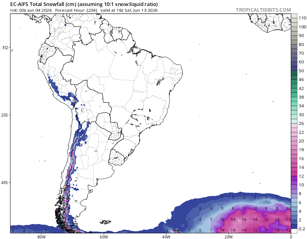
A new episode of #snowfall is expected later this week in the Andes.
✅The heaviest and most widespread snowfall is expected around the Southern Andes, while in central Chile it should be confined to lower accumulations.
🌎 NOAA has officially declared the onset of El Niño
El Niño is the warm phase of ENSO, during which surface waters in the central and eastern tropical Pacific become warmer than usual.
As the distribution of warm water in the Pacific shifts, atmospheric circulation also changes, including the position of the jet stream and storm tracks. This can influence temperatures and rainfall thousands of kilometres away.
Current seasonal forecasts suggest that El Niño will continue to strengthen through the rest of the year. According to NOAA, there is a 60% chance that sea surface temperature anomalies in the central and eastern tropical Pacific will exceed 2 °C by the end of the year. This episode could therefore become very strong and rank among the strongest events on record.
Typical impacts of El Niño:
• globally: an increase in the planet’s average temperature
• more rainfall: western and southern South America, parts of East Africa, and the southern United States
• drier conditions: northern and eastern Australia, Indonesia, parts of Southeast Asia, southern Africa, and parts of Central America
• South Asia: the southwest monsoon is often weaker
• tropical cyclones: less favourable conditions in the Atlantic, a more active eastern and central Pacific, and typhoon formation in the western North Pacific often shifting farther east
EUROPE | HEATWAVE SOON?
✅A strong low will bring wind gusts and unsettled conditions to northeastern Europe as we head to the weekend. Although below average temperatures are expected for a brief period, a new heatwave setup is becoming likely from next week.
The first major winter storm of the season finally arrived to the Andes across southern #Chile and #Argentina.
✅Around 50-70 cm of #snow expected above 1,500 meters, while elevations at 1,100 m could expect around 10-20 cm.
🌨️Much needed mountain #snow is under way for southern #Chile and #Argentina within the next 72h.
✅An active storm track in the southern Pacific combined with a polar surge will favour 3 rounds of snow throughout Friday with accumulations of 20/30cm expected above 1200 mts.
🌀 Tropical storms Boris and Cristina threaten the Pacific coast of Mexico and Central America
Tropical Storm Boris is moving inland along Mexico’s Pacific coast, southeast of Acapulco.
Tropical Storm Cristina has formed near the Pacific coast of Central America and will move near the coasts of Nicaragua, Honduras, and El Salvador on Tuesday and Wednesday. It is likely to move inland near El Salvador.
Despite their expected rapid weakening over land, both storms will still bring very heavy rainfall.
Boris: additional rainfall totals of 3 to 6 inches (75 to 150 mm), locally up to 8 inches (200 mm), across coastal Guerrero and Oaxaca in Mexico.
Cristina: rainfall totals of 4 to 8 inches (100 to 200 mm), locally up to 12 inches (300 mm), across coastal areas of Nicaragua, Honduras, El Salvador, and Guatemala.
The rainfall may cause life-threatening flooding and mudslides, especially in areas of steep terrain. Dangerous surf is also expected along the coast.
⚠️ Please follow the latest warnings and instructions from local authorities.
Tropical Depression Two-E will bring dangerous weather to southern Mexico near Acapulco. Heavy rain may trigger life-threatening flash flooding and mudslides, especially in mountainous areas.
Tropical storm conditions are expected along the coast tonight and into Monday.
Above average #rainfall over southern Brazil/Bolivia this week. ITCZ influences the Guianas, Suriname, Colômbia, Ecuador, Peru, Venezuela & N.Brazil. Tropical disturbances affect eastern Brazil. Dry across central Brazil. Cold fronts increase rain/snow conditions in the Andes.
Heavy #rain should persist over #CentralAmerica in the second week of June.
🌧️Tropical disturbances in the Pacific will bring flood threats to El Salvador, Honduras, Nicaragua, Costa Rica and Southern Mexico, while another tropical disturbance will influence Jamaica and Cuba.
A remarkable 3.5˚C rise in central equatorial Pacific Ocean temperatures is possible by November, shows new ECMWF, which would mark the strongest El Niño on record.
Possible strength scenarios range from +2.8˚C to +4.3˚C, with sweeping consequences on global climate into 2027.
Finally, pre-monsoon thunderstorms are now extending to Telangana, north Karnataka, Andhra Pradesh, and Odisha. This will gradually make conditions favorable for some progress of the monsoon.
A agência Climatempo prevê mês de junho com temperaturas dentro à abaixo da média no sul do Brasil, seguindo a projeção semanal do ECMWF, atualizada diariamente.
Chuvas acima do normal entre o Paraná e sudeste/centro-oeste, e abaixo no RS.
ASIA RAINFALL
Extreme rain impacts expectes over South Asia and East China. Tropical storm #Jangmi also to impact Japan with over 250mm expected in southern areas.
Convective rains over parts of Indonesia and monsoon activity increases over southwest India.
CENTRAL AMERICA RAINFALL
- Rainfall totals over 150mm across Panamá, Costa Rica, Guatemala and Belize due to monsoon, the ITCZ alongside tropical waves. An atmospheric trough also brings storms into Cuba and the Bahamas. Drier conditions in Puerto Rico & the Dominican Republic.
#Rainfall (1-8 June) Monsoon rains / ITCZ influences the Guianas, Suriname, Colômbia, Ecuador, Venezuela N.Brazil. Atlantic easterlies influence eastern Brazil.
Warm & dry across central South America. Wetter conditions return to central Argentina provinces & Chile this week.