@SCweather_wx What an idiot. This is what I was worried about. Columbia and east being cheated. Haven’t seen a DROP in Sumter. Hoping for better luck tomorrow.
@SCweather_wx Sharp cutoff from upstate SC to lowcountry. A little worrisome that some locations may see half an inch and others see 3. The whole state needs this.
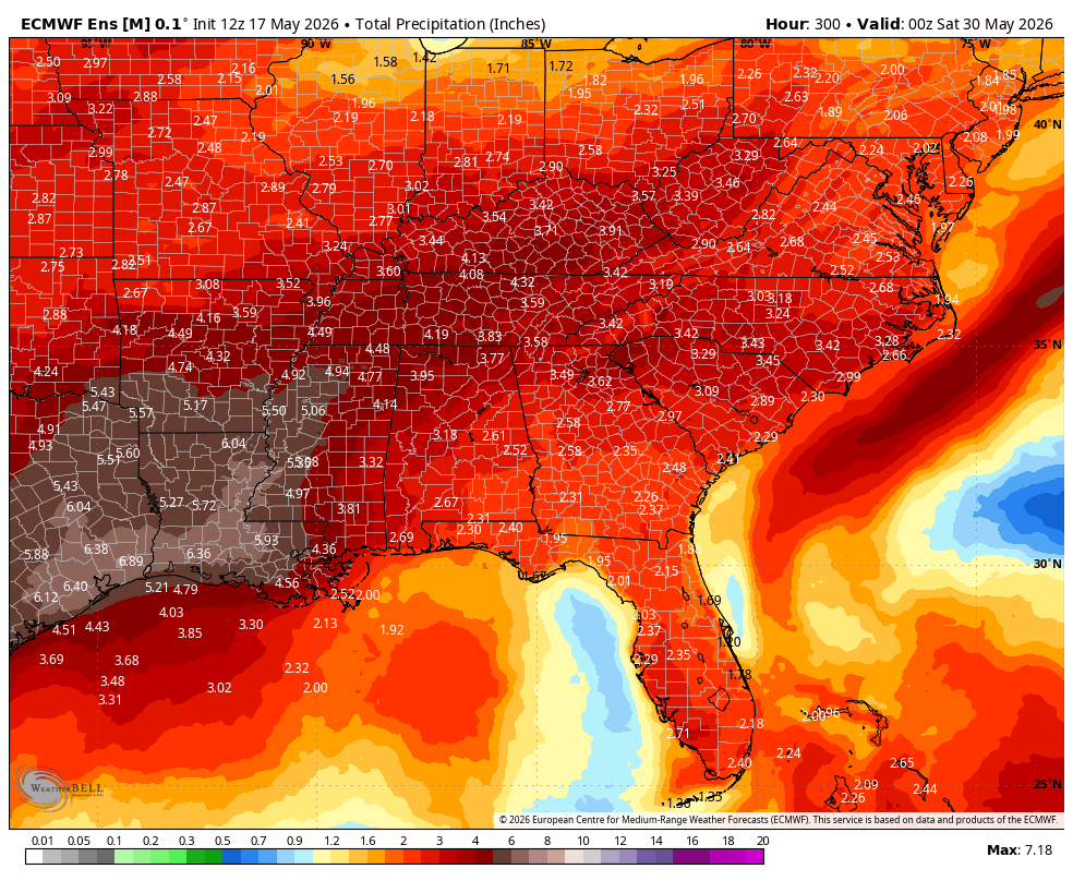
This afternoons EPS continues to highlight a significant shift to a more rainy/stormy pattern across the South. Below is the EPS through May 29th.
This is a combination of a cold front later this week along with an active Southern jet getting going across the Southern tier. The South Central US will benefit the most off this. The Southeast could benefit from moist Southernly flow around high pressure that will be centered more out in the Atlantic. Ridge placement may keep a stronger surge of moisture through the Deep & Mid South. Very El Niño like pattern coming up IMO.
@NWS No hate on the NWS, but this was a massive error in forecasting. Public trust will be at an all time low when severe weather like this actually does happen. You need to address this situation and try to regain public confidence.
@ChrisJacksonSC I agree, this is not your fault. This is why the public does not take actual threats seriously, because this was supposed to be one of the biggest threats the southeast has seen in a long time, yet these storms have barely met severe criteria. This is a major forecasting error.
3/15 5:30 PM Update: A potentially significant severe weather event remains on track to affect the Midlands and CSRA tomorrow (3/16/26). All severe hazards are possible as a line of storms moves through. #scwx#gawx
@EthanBolziccoWX Hey, could you share as to why you think that a dramatic shift north could happen in a setup like this, despite model guidance actually supporting more of a southern solution with increasing cape and elevating tornado parameters for the fl/ga/sc areas?
Rotation being spotted across parts of Arkansas and Missouri. These areas are in a slight risk, level 2/5 for severe weather and still seeing severe thunderstorms accompanied by rotation. @SCweather_wx
@TKorn_1@SCweather_wx I would say just be wary of your surroundings, stay updated because with supercells, one minute it can be a nice sunny day, the next you can be looking out your window at hail.
@SCweather_wx Tomorrow will definitely bring gold and bad surprises. I hope everyone can enjoy the beauty of Mother Nature and its wrath without injury.