#DOLPHIN is now a super typhoon, with winds of 130 kts (150 mph). The eye has began clearing out, and intense convection is wrapping around — presentation is that of a soon-to-be high end tropical cyclone.
The JTWC now calls for a 155 kt (180 mph) peak intensity, but I wouldn’t rule out a stronger intensity with this look.
Post-Tropical Cyclone #Fausto Advisory 43 (5 AM HST, Wed Jul 29): Fausto Degenerates to a Remnant Low Pressure Area. Significant Surf Still Expected for the Hawaiian Islands Through Today. https://t.co/Oy8uoeRKme
This is unbelievable. The JTWC now expects Typhoon #DOLPHIN to achieve a peak intensity of 165 kts (190 mph). This is one of their highest intensity forecasts ever.
DOLPHIN has developed a very compact structure with a classic pinhole eye. With pristine conditions ahead, there’s a reason for its forecasted intensity.
15 hours later and #Dolphin is likely already on the cusp of becoming a category 5 typhoon. Truly one of the most insane intensification phases since Hagibis in 2019 I'd reckon... if only we had recon in the WPAC still.
Coincidentally, during the last developing super El Niño, 2015’s Typhoon Dolphin reached Super Typhoon CAT 5 intensity. This iteration of Dolphin has a solid chance of doing the same
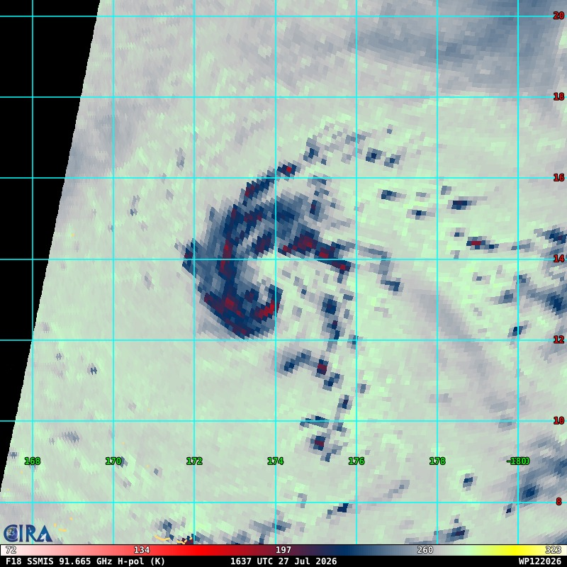
Tropical storm #Dolphin 🐬 (one of the coolest WPAC names btw) seems primed to imminently begin a period of rapid Intensification. A recent MW overpass showcases an incipient, spatially small core, with VHT activity increasing over the past several hours.
The model solutions for this system are exceptional, which makes sense given the largely favorable environment ahead.
By the looks of it #Dolphin is intensifying at a rate rarely seen even in the West Pacific. While officially still a TS, there's a very good chance that this is already a typhoon with a nascent eye already being seen on IR.
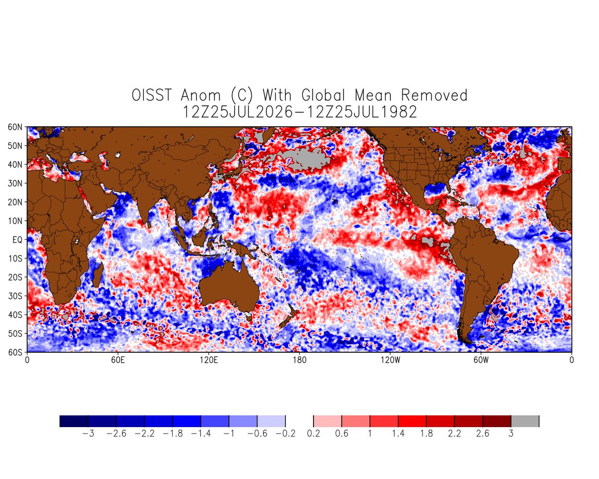
Interesting to look at the latest SST comparisons with historical analogs. I've plotted 1982, 1997, 2015, and 2023 here. 2026 is blowing most of the historical El Niño events out of the water. Only 1997 is really comparable (once you remove the global mean to account for the long-term trend).
The other thing that stands out is the big "warm blob" east of Japan. That's keeping our PDO index positive even though the water off Mexico/California is much warmer than usual (+PMM signature).
Nothing really jumps out in the Atlantic. It's much cooler than 2023 (not surprising), but warmer than 1982 (which was the middle of the cold AMO era).
Hurricane #Genevieve Advisory 12 (2 AM MST, Mon Jul 27): Genevieve Becomes the First Category 5 Hurricane in the East Pacific Since Kristy of 2024. https://t.co/Oy8uoeRKme
Hurricane Genevieve is making a run for category 5 intensity — there aren’t any readily apparent signs of an eyewall replacement cycle, and its eye continues to steadily warm while eyewall cloud tops steadily cool & become increasingly axisymmetric.
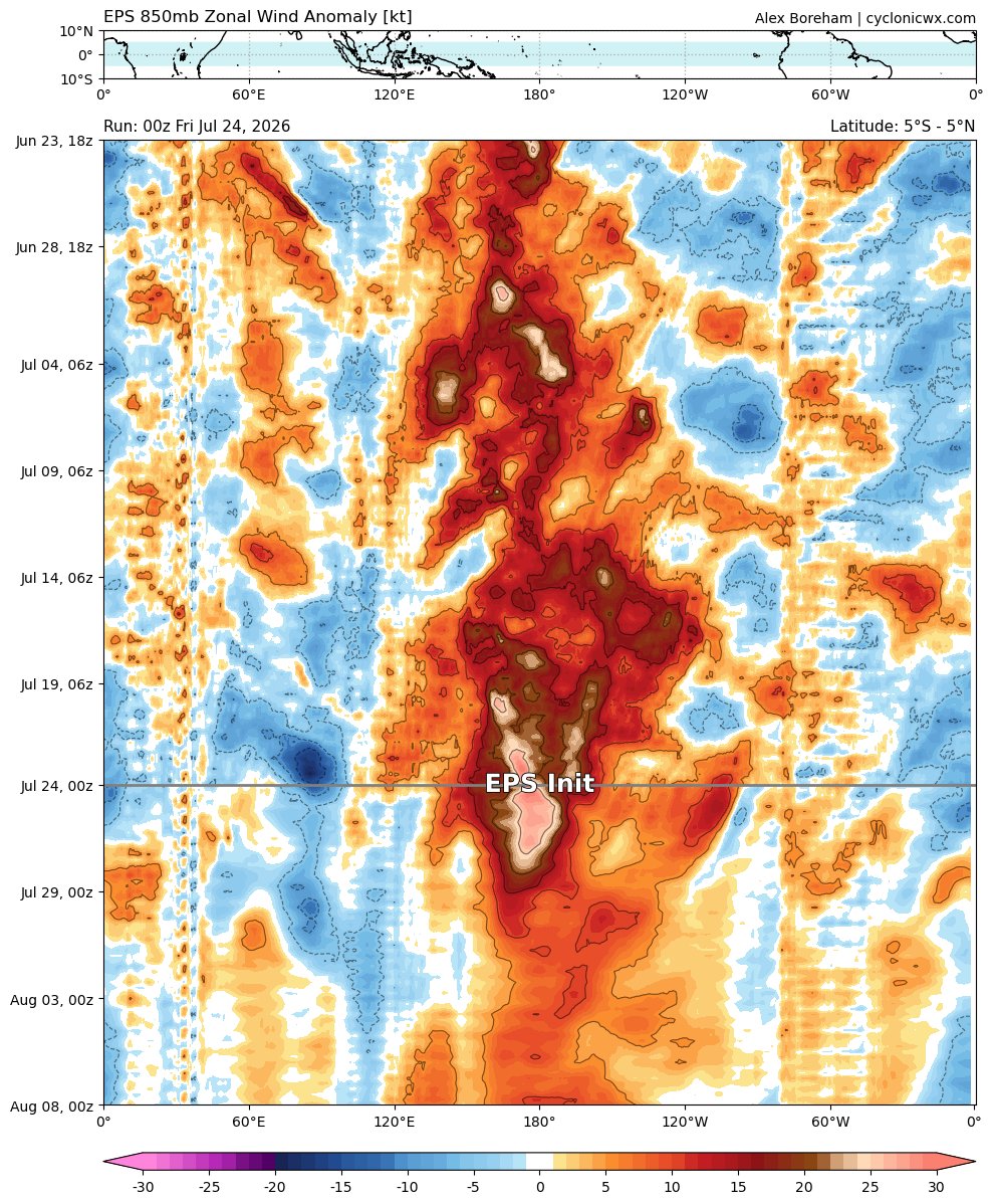
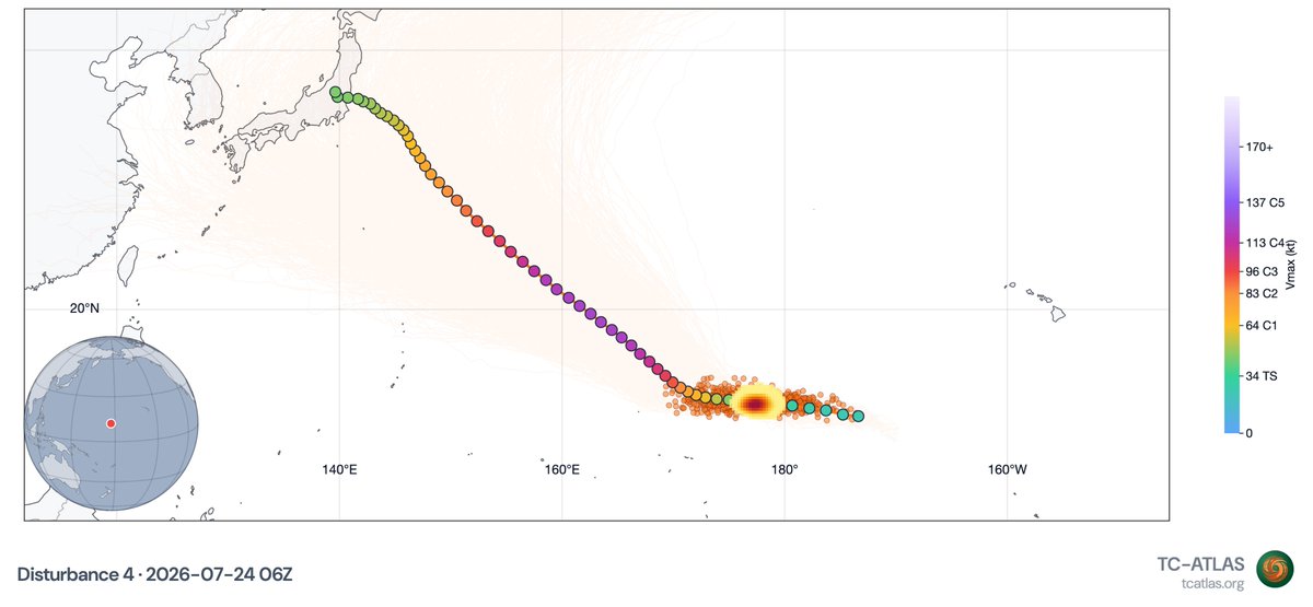
#92C looks to have developed now with the help of a very strong WWB. It will traverse much of the West Pacific, including the patch of record SSTs, and most likely end up a powerful typhoon
Hurricane #Genevieve Advisory 7 (8 PM MST, Sat Jul 25): Genevieve Now a Hurricane. Forecast to Rapidly Intensify Over the Next Day or So. https://t.co/Oy8uoeRKme
Another extremely strong westerly wind burst (WWB) is ongoing across the Central Pacific. This will help our El Niño event keep pushing into record territory, and also help spin up another likely strong typhoon in the West Pacific.
Images from @cyclonicwx, @weathernerds, and TC-Atlas from @MikeFischerWx
Tropical Depression #Seven-E Advisory 1 (9 AM CST, Fri Jul 24): Tropical Depression Forms Over Open Waters of the Eastern Pacific. Expected to Quickly Strengthen During the Next Few Days. https://t.co/Oy8uoeRKme