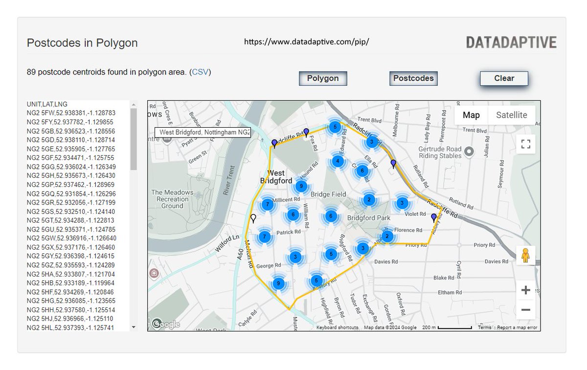
Postcodes in Polygon: an #opendata tool from @datadaptive – draw a shape on a map, get a list of postcodes https://t.co/6qiTuHlI1f (Great Britain only)
Now updated with postcode data from the latest release of the ONS Postcode Directory (May 2026)
Postcodes in Polygon: an #opendata tool from @datadaptive – draw a shape on a map, get a list of postcodes https://t.co/6qiTuHlI1f (Great Britain only)
Now updated with postcode data from the latest release of the ONS Postcode Directory (February 2026)
Postcodes in Polygon: an #opendata tool from @datadaptive – draw a shape on a map, get a list of postcodes https://t.co/6qiTuHmfQN (Great Britain only)
Now updated with postcode data from the latest release of the ONS Postcode Directory (November 2025)
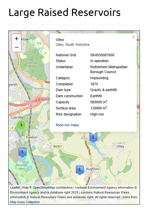
Updated: Large Raised Reservoirs in England and Wales https://t.co/A5wScDTest
This dataset contains point locations with a range of attributes, in CSV, KMZ and GeoJSON formats
There's also an interactive map https://t.co/6gR4ApUSsB
#reservoirs#floodrisk#geospatial#opendata
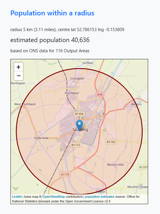
This tool from @datadaptive, which estimates the resident population for areas of England and Wales within the radius of a selected point, has been updated with the latest small area population data from ONS:
Population within a radius https://t.co/3OHMtTUGdk #opendata#datavis
Updated: Jobcentre Locations GB https://t.co/eUWtAXzleh a free dataset of addresses and point locations for Department for Work and Pensions #jobcentres in England, Scotland, and Wales
#DWP#geospatial#opendata
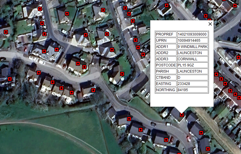
Open addresses in the UK: Council Tax address lists available as open data https://t.co/noqAHN9U8x
New collection of geocoded address datasets for:
● Birmingham
● Cornwall
● Hackney
● Leeds
● Lichfield
● Rushcliffe
CSV and geoJSON formats
#openaddresses#opendata
Postcodes in Polygon: an #opendata tool from @datadaptive – draw a shape on a map, get a list of postcodes https://t.co/6qiTuHlI1f (Great Britain only)
Now updated with postcode data from the latest release of the ONS Postcode Directory (August 2025).
Updated: Jobcentre Locations GB https://t.co/eUWtAXzT3P a free dataset of addresses and point locations for Department for Work and Pensions #jobcentres in England, Scotland and Wales
#DWP#geospatial#opendata
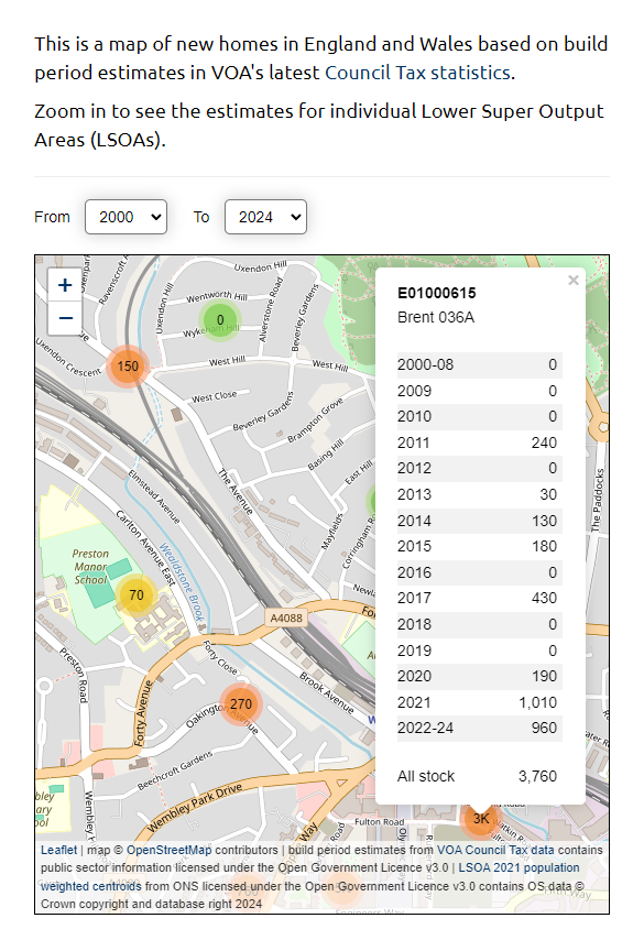
Here are two interactive maps of England and Wales, built using the same @VOAgovuk source data:
● New build homes since 2000 https://t.co/11xKp8MA4q
● Net change in housing stock counts since 2010 https://t.co/9zfYiONNKN
#UKhousing#proptech#opendata#ageofhousingstock
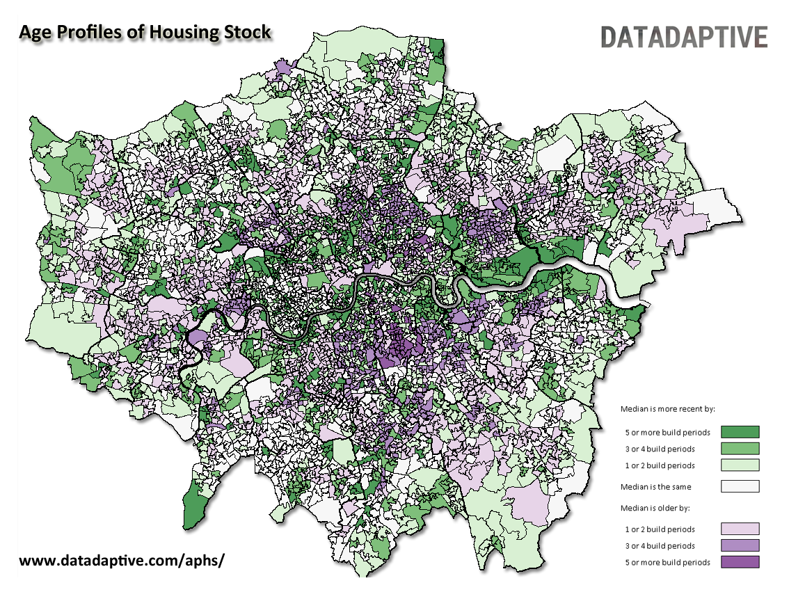
Age Profiles of Housing Stock https://t.co/2LauYWaBVB
Updated for 2024: @datadaptive's free dataset of build period statistics for neighbourhoods in England and Wales.
There's also a postcode lookup tool https://t.co/yikeSfZymn
#UKhousing#proptech#opendata#ageofhousingstock
Postcodes in Polygon: an #opendata tool from @datadaptive. Draw a shape on a map, get a list of postcodes. https://t.co/6qiTuHlI1f (Great Britain only)
Now updated with postcode data from the latest release of the ONS Postcode Directory (November 2023).
Updated: UK Post Office Branch Locations https://t.co/x2ELnFwUDf #postoffices#geospatial#opendata
This free spatial dataset contains addresses, point locations, and opening times for @PostOffice branch locations in the UK, in SHP and CSV formats.
Postcodes in Polygon: an #opendata tool from @datadaptive. Draw a shape on a map, get a list of postcodes. https://t.co/6qiTuHlI1f (Great Britain only)
Now updated with postcode data from the latest release of the ONS Postcode Directory (August 2023).
Updated spatial dataset, with point locations and attributes in Shapefile, KMZ and CSV formats:
Large Raised Reservoirs in England and Wales https://t.co/A5wScDTest #reservoirs#floodrisk#geospatial#opendata
Related blog post with interactive map https://t.co/6gR4ApUSsB
2023 update to @datadaptive's free dataset of build period statistics for neighbourhoods in England and Wales:
Age Profiles of Housing Stock https://t.co/2LauYWa463 #ageofhousingstock#UKhousing#proptech#opendata
There's also a postcode lookup tool https://t.co/yikeSfZ0wP