Short term Pessimist and a long term optimist. Friends are for life. Can't live without Google, Music and books. Interests in War history, OSINT FREAK..
Had a conversation with Iranian President, Dr. Masoud Pezeshkian, to discuss the serious situation in the region.
Expressed deep concern over the escalation of tensions and the loss of civilian lives as well as damage to civilian infrastructure.
The safety and security of Indian nationals, along with the need for unhindered transit of goods and energy, remain India’s top priorities.
Reiterated India’s commitment to peace and stability and urged for dialogue and diplomacy.
@drpezeshkian
BREAKING: A Chinese AI startup called MizarVision is publishing high-resolution satellite imagery of every US military base, every carrier strike group, every F-22 deployment, every THAAD battery, and every Patriot missile position in the Middle East. Labelled. Geolocated. AI-annotated. Updated in near-realtime. Shared by PLA-linked accounts and Chinese state media to an audience of billions.
The first major release came on 20 February, eight days before Operation Epic Fury began. MizarVision published images showing US aircraft transfers to Ovda Airbase in southern Israel, fighter deployments across Saudi Arabia and Qatar, and naval buildups in the Arabian Sea. By 1 March, the releases had expanded to include detailed imagery of bases in Jordan, Kuwait, Bahrain, and the UAE, with AI labelling identifying specific aircraft types, air defence configurations, and troop concentrations. One release catalogued approximately 2,500 individual US military assets across the region.
The imagery comes from two sources. The first is China’s Jilin-1 satellite constellation, a network of over 100 commercial Earth observation satellites operated by Chang Guang Satellite Technology, whose data is used by the PLA. A majority of Jilin-1 satellites are dedicated to regional imaging with sub-metre resolution, capable of identifying individual aircraft on tarmacs and distinguishing between THAAD and Patriot battery configurations from orbit. The second source is commercially available Western satellite data from providers like Maxar and Airbus, which MizarVision aggregates, processes through proprietary AI models for automatic target recognition, and republishes with military-grade labelling that transforms raw imagery into actionable intelligence products.
The Pentagon has downplayed the releases as “open-source.” This framing misses the point entirely.
The value of MizarVision’s output is not the raw satellite image. Any government can purchase commercial satellite passes. The value is the AI processing layer that converts terabytes of imagery into labelled, searchable, cross-referenced intelligence products at a speed and scale that previously required the resources of a national intelligence agency. MizarVision is democratising military surveillance and publishing the output on social media where Iran’s 31 autonomous IRGC provincial commands can access it from a mobile phone.
No direct evidence confirms classified data transmission from Beijing to Tehran. But the distinction between “classified” and “publicly shared AI-processed satellite intelligence identifying every US military asset in the Middle East by type, location, and configuration” is a distinction without a meaningful difference to a provincial IRGC commander selecting his next target.
The strategic implications extend far beyond this conflict. In the 2022 Ukraine war, Maxar’s commercial satellite imagery aided Kyiv by exposing Russian deployments. The West celebrated it as the democratisation of intelligence. China has now executed the identical playbook in reverse: a nominally commercial firm, with documented PLA data-sharing arrangements, publishing intelligence products that expose American deployments during an active war. The precedent is set. Commercial satellite intelligence is now a weapon of great-power competition deployed through AI startups with plausible commercial deniability.
MizarVision has fewer than 200 employees. Its AI models run on commercially available hardware. Its satellite data comes from constellations any nation can build. And it has just demonstrated the capability to map every US military asset across an entire theatre of war and publish the results on the open internet before the first bomb falls.
The next war will not begin with a missile launch. It will begin with an AI model labelling every target from orbit.
Full analysis - https://t.co/eMrt5qYYst
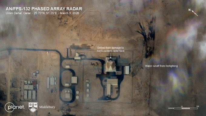
Planet labs has released images of damage to the giant 5000km range AN/FPS-132 radar that the US installed in Qatar. Before & after images show the (crucial) north eastern radar face obliterated. Presumably extensive damage to the other 2 faces from inside
EXCLUSIVE ⚠️
India Quietly Moves Forward With Homegrown Sheshnaag-150 Low Cost Attack Drone As US & Iran Deploy Similar Drones In Ongoing War https://t.co/WxCPD9uOMC
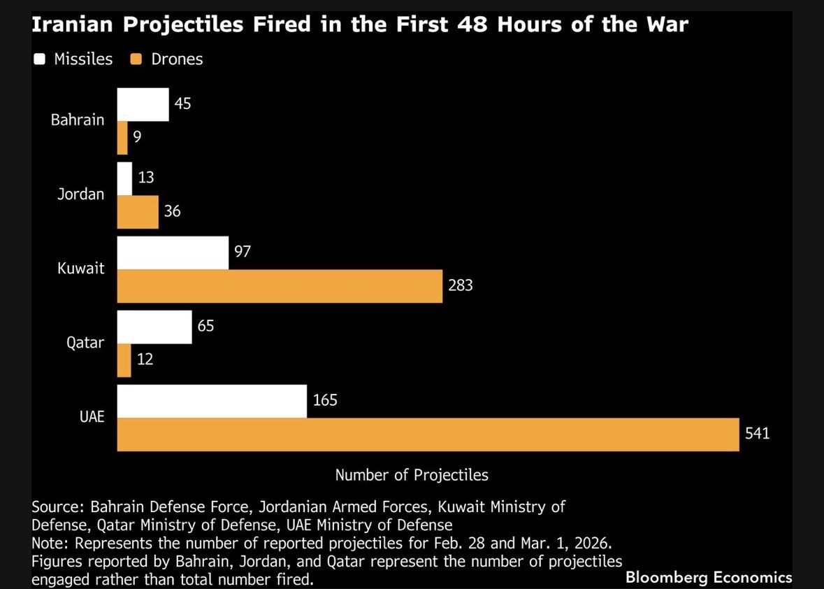
Iran fired 1200+ projectiles at five countries in the first 48 hours. Most were drones. These saturation attacks aim to overwhelm air defenses and drain interceptors. $20-50k Shahed drones vs. $4.19M PAC-3 interceptors put US and its partners on the wrong side of the cost curve.
Yet another massive tunnel storage complex of Chinese PLA in Tibet. This one is located ~60 km from Indo-Tibet border as the crow flies. Its most likely role should be secure storage of war supplies. The admin complex has a reinforced underground section too. It has seven tunnel entrances with huge piles of excavated rubble outside. They seem to be using explosives for excavation.
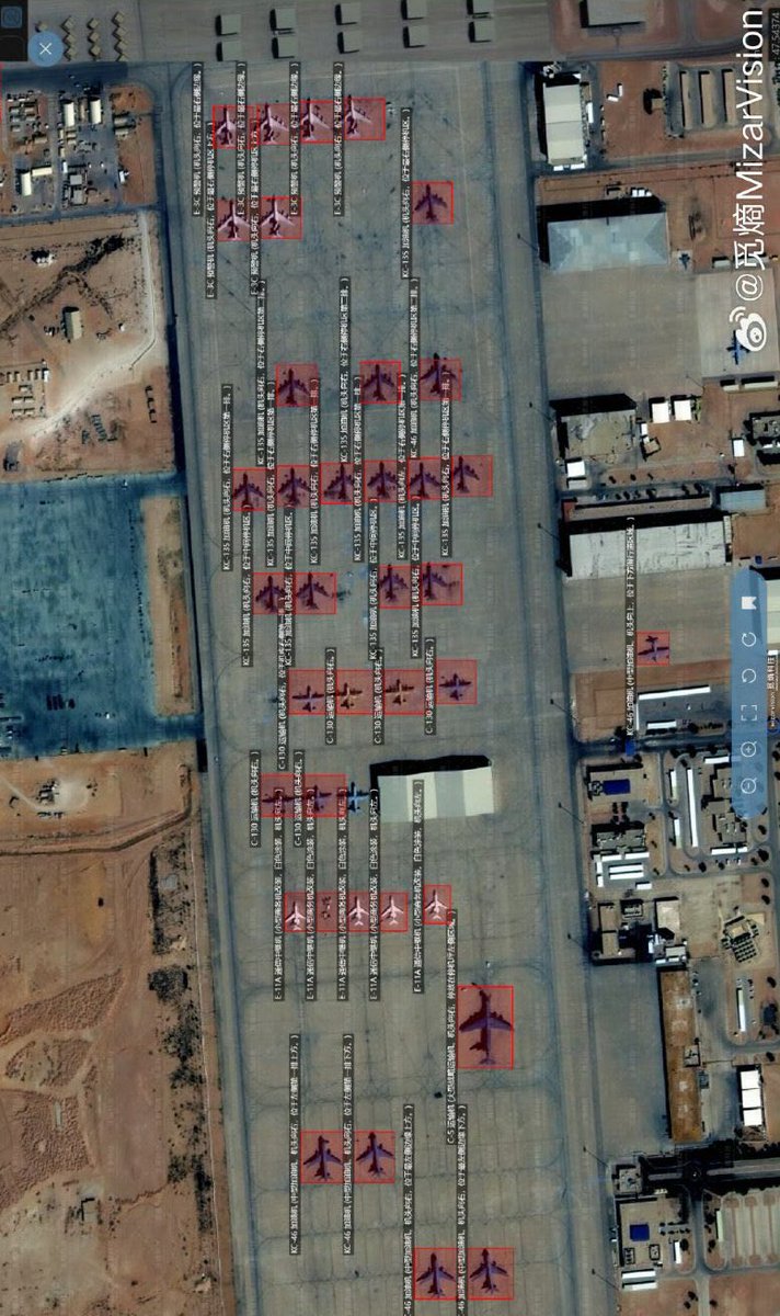
Look at this image carefully. You are looking at a Chinese commercial satellite photograph of Prince Sultan Air Base in Saudi Arabia. Every red box is an artificial intelligence model identifying a US military aircraft by type. Every label is in Mandarin. And the base you are looking at is the one Iran fired ballistic missiles at on Saturday night.
A company called MizarVision, founded five years ago in Hangzhou, published this. Not the Pentagon. Not the CIA. Not a classified intelligence briefing delivered to the Situation Room. A Chinese startup with access to sub-meter resolution Earth observation satellites and an AI object detection model that can distinguish a KC-135 Stratotanker from a KC-46 Pegasus from orbit.
Aviation Week confirmed what the image shows. Fifteen KC-135 aerial refueling tankers. Six KC-46 Pegasus tankers. Six E-3 Sentry airborne early warning aircraft, which is significant because only thirty one E-3s remain in the entire US Air Force inventory worldwide, meaning roughly a fifth of America’s operational AWACS fleet is parked on a single ramp in the Saudi desert. Two E-11A Battlefield Airborne Communications Nodes. C-130 Hercules transports. C-5 Galaxy heavy lifters. The backbone of Operation Epic Fury, catalogued from space and published on Weibo.
This is the base that Iran targeted. AFP journalists in Riyadh reported explosions in the eastern part of the capital with thick smoke rising. The Saudi Foreign Ministry condemned Iranian attacks targeting Riyadh and the Eastern Province. Saudi air defenses intercepted the projectiles. But the image you are looking at was published days before the strike. Which means Iran had exactly the same intelligence picture that MizarVision gave the entire world for free.
This is what the democratization of intelligence looks like. In 1991, only the United States could see individual aircraft on a ramp from space. In 2003, a handful of nations had that capability. In 2026, a Chinese startup publishes annotated satellite imagery of American force dispositions on social media, and Aviation Week runs the analysis before the first missile is fired.
Defence Security Asia captured what this means: sub-meter resolution imagery distinguishing individual aircraft types fundamentally alters the secrecy calculus of pre-strike deployments. You cannot mass two hundred aircraft across half a dozen bases and keep it secret when commercial satellites photograph every ramp twice a day and AI models label every airframe before an analyst finishes their coffee.
The age of hidden buildups is over. Every deployment is now observable, catalogued, and published in near real time by companies with no security clearance and no allegiance to anyone. The next war will not be planned in secret. It will be watched from orbit by everyone, in every language, simultaneously.
https://t.co/BrzGRrU3VW
JUMPSEAT, the United States’ first-generation, highly elliptical orbit (HEO) signals-collection satellite, has recently been declassified!
Learn more about its history here: https://t.co/M1O5CaB1Tu
Kaveri ‘Dry’ Engine (KDE)
The altitude testing of the engine was carried out during Oct-Dec 2022 at CIAM, Moscow. During 2023, the engine was brought back to GTRE/DRDO and the complete disassembly of the engine
has been carried out. No major distress on any of the part was observed during the disassembly inspection.
A total of 38 ASMET cycles has been completed on the second prototype engine at GTRE test bed. The problems encountered during the altitude testing have also been resolved and the ground testing at GTRE on engine has been carried out to prove that the solutions are working in the engine condition.
📸 : @Amitraaz
A total of 19 Pak planes were damaged by IAF during #OperationSindoor. 6 jets in Air including 1 AWACS and 13 in Hangers including 1 AWACS, 1 Il-78MP Midas refuelling tanker, 1 C-130 and 10 fighter jets" 🔥
- Austrian Military aviation analyst Tom Cooper
Just because Alan Warnes was allowed to visit their air bases this magazine is suggesting all the social media accounts to prove the fantasy league the PAF is in. You should rather improve the standards of not just editing but your editor too Airforces Monthly
Latest issue of AFM on sale since Wednesday in UK. Well worth a read, particularly the 16 page feature on Understanding the Rafale kills. It's behind a paywall, but for an intro see here: https://t.co/uusC648HcP
Best thing @realDonaldTrump has did for India is to make sure it understood how fatal it is to have thought Americans as friends. They are always selfish and have a very crude idea of valuing any relationship it's time we should go full throttle towards BRICS currency even if we had to loose something in short term. Over long term it will help break this American hegemony over everything. Without their dollar, US is nothing. This attention seeking disorder will have to be cured and India should stand up to the bully and say No thanks.
As we approach this year's Independence Day, I look forward to hearing from my fellow Indians!
What themes or ideas would you like to see reflected in this year’s Independence Day speech?
Share your thoughts on the Open Forums on MyGov and the NaMo App...
https://t.co/dG2b2IjnCD
https://t.co/5QtD2aKaBe
Alfred Noble will raise from his tomb and commit suicide thousand times if something like this happens @NobelPrize@NobelPeaceOslo If money power is the only criteria then go ahead
India should never rely on US. They have always been like this. They will ditch u when they want. Best option for India is to go full on for BRICS currency. US is nothing if not for their currency printing spree. It's dominance will fall once that is shattered. This bully should be bullied to the core.
💡Don't look at #Trump as the US President. Look at him as a snake oil salesman with a hyperbolic vocabulary. He will say and do anything and everything to assume and proclaim victory at that point in time. #Pakistan has modest oil reserves and the US getting in won't augur well.