🚨 TRADE ALERT 🚨
The Detroit Red Wings trade goaltender Sebastian Cossa for the 23rd overall pick in the 2026 NHL Draft (used to draft J.P. Hurlbert). #LGRW
Thoughts on the last second deal from Yzerman? ⤵️
*BREAKING*
TORCON upgraded to a 7. There is a likelihood of intense EF3+ tornadoes today in Iowa and Illinois. This threat is very close to Chicago. Please be weather alert today and have plans to be in a safe structure when the storms arrive this afternoon/evening.
🚨 JUST IN: Vice President JD Vance CHEST BUMPS a US Air Force graduating cadet during commencement
Lmao, that moment made his whole day! 🤣🔥
Vance is PERSONALLY there shaking all their hands 🇺🇸
They love JD!
MURKY WATERS
Clear skies over Michigan today provided an incredible view of muddy flood waters inundating the Great Lakes.
Following an onslaught of rain the last few weeks, western Lake Erie, Lake St. Clair, and the western bay of Lake Huron are particularly murky.
If you look closely, you can also see several rivers draining into Lake Michigan including the Grand, Muskegon, and Manistee.
Check out this unique sight with FREE GeoColor imagery in WF!
🚨 JUST IN: Iran has agreed to a 100% FULL HALT to their nuclear program, for an UNLIMITED amount of time...
...and President Trump won't be giving them a DIME, a single CENT — not even "releasing frozen Iranian funds"
ART OF THE DEAL!! 🔥
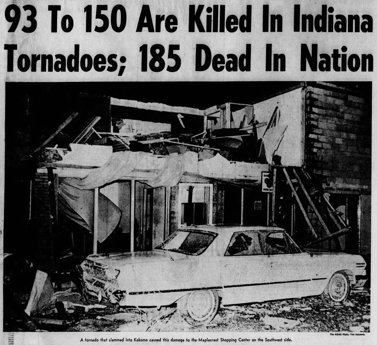
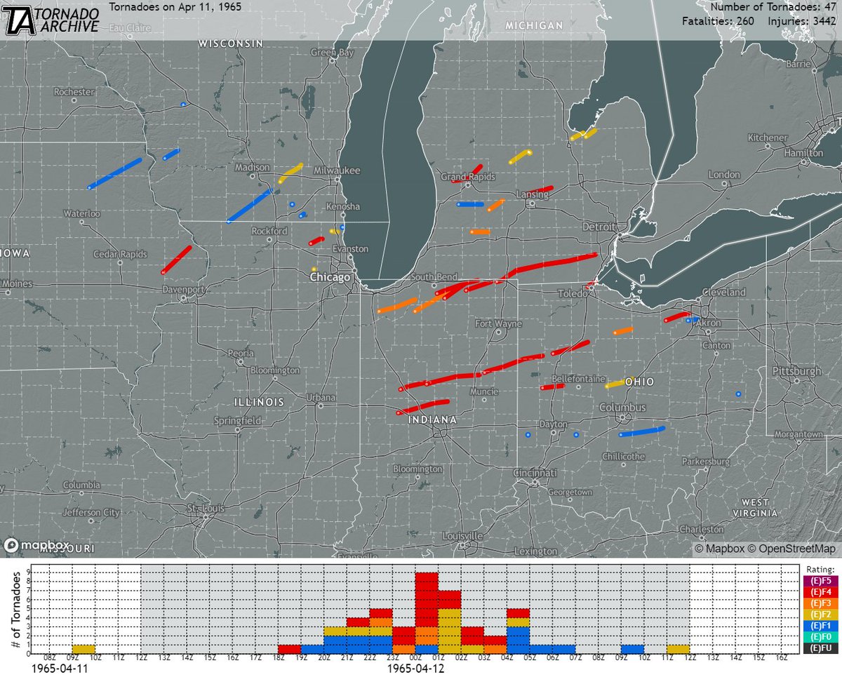
April 11, 1965:
One of the worst tornado outbreaks in US history struck the Great Lakes region. Nearly four dozen tornadoes (17 of which were rated F4) slammed numerous towns and cities, resulting in ~260 fatalities, >3400 injuries, and billions of dollars in damage.
#wxhistory
Check out my first ever news interview when I was 18 on the storm chase of the F5 on May 3, 1999 from Bridge Creek to Moore, Oklahoma. This was the very beginning of working with media as a storm chaser for the next 25 years
#stormchasing#Dominator#weather
Michigan came EXTREMELY close to a higher-end localized tornado event in southwestern Michigan last night, April 2nd.
Six primary cells were responsible for five different tornado warnings issued by our local National Weather Service offices in Grand Rapids and North Webster, IN. With directional shear readings three to five times the preferred values, there was enough spin in the atmosphere for everyone to share. Thankfully, by the hairs on our chin, we were slightly less unstable thanks to the warm front and clearing cloud cover slowing their speeds as they advanced into Michigan by early-afternoon.
Kalamazoo county saw four separate tornado warnings issued throughout the evening, the most out of any county, while Battle Creek was dubbed the luckiest city of the evening, as two very strong rotational couplets passed through city limits on the west side, and the east side of town within 45 minutes of each other. Other weaker pockets of rotation occurred towards Tekonsha, Union City, and Sturgis.
Still, we may have had a couple brief spin-up tornadoes undetected by radar and storm chasers. If you have any damage to report, do so with a date, time it occurred, location, and measurement if plausible. Surveys are conducted by the NWS, so any information to pass along should be done so today.
Here at Michigan Storm Chasers, over 500,000 viewers tuned in to our life-saving severe weather coverage last night. We are very thankful that NO tornadoes (that we know of) touched down, and that many of you were able to take shelter many minutes in advance due to timely heads up. Huge shoutout as well to the local NWS offices for being on top of those rotating cells. Not one strong couplet went unwarned.