@_BLENDERender Please no, I don't like to see my addon used as phishing to collect personnal data. If you want to reference it then just put the direct link to the github page WITHOUT billing process.
@kentelTICE @Fabio_Lacchini @Blender Fonctionne correctement de mon côté avec Blender 2.92. Ouvrir une issue dans le dépôt Github avec les éventuellement messages d'erreur. (Possible de rédiger en Français)
#QGIS 3.18 + #GEOS 3.9 finally I'm abble to union these 2 shoddy layers of 80k features each without any errors. Waiting this moment for years ! Thanks @qgis
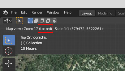
@davvyk Well I'm sorry for my poor english, I'll try to explain it more simply : when you run the basemap operator you can pan and zoom to your location of interest. Then if you want to lock the map extent while downloading more detailled texture, just press the L shortcut and zoom it
@mapperfr @Blender There is no issue here, in WGS84 x and y coords are in degrees but z is in meters. See the FAQ https://t.co/yhBpxi7TNN
Good to know you found the solution !
@odtvince@cq94@ChristopheVe @bzg2 @Etalab@datagouvfr Pour info on peut remonter jusqu'aux paiements de 2013 en changeant le paramètre dans l'url suivante : https://t.co/TJ6jTjXDXy
campagne 2015 = Paiements oct 2013 à oct 2014
campagne 2016 = Paiements oct 2015 à oct 2016
...