GeoLibre v1.1 is out!
GeoLibre is a free and open-source, lightweight, cloud-native GIS platform for visualizing, exploring, and analyzing geospatial data. One application that runs everywhere: in your web browser, as a native desktop app, on your phone, and inside a Jupyter notebook. No account, no server, no cost. Everything runs locally and your data stays private.
This release builds on the v1.0 foundation with features that make day-to-day mapping smoother:
- Attribute table management — rename, delete, hide/show, and reorder fields right in the table, with the layout saved to your project.
- Data-driven symbology for Add Vector Layer — single, categorized, graduated, and expression-based styling now applies to maplibre-gl-vector layers.
- Atmosphere Effects plugin — a deep-space backdrop, parallax starfield, comets, and a glowing globe halo at low zoom (toggle it from the Controls menu).
- Layer panel upgrades — rename layers, open the attribute table, and export straight from the layer actions menu.
- Auto Refresh extended to Add Vector Layer URL layers.
- In-browser GeoPandas via Pyodide — run the vector tools with no Python sidecar, same results.
- Plugin API — external plugins can now render on the host's shared https://t.co/Iu3zs18eJk instance via app.getDeckGL().
Try the live demo: https://t.co/hOVekblXMc
Star it on GitHub: https://t.co/VXq8c1o2Nd
Docs and roadmap: https://t.co/7VA2AQoCUc
Release notes: https://t.co/MDAw3GkChj
#GIS #OpenSource #Geospatial #MapLibre #WebGIS #DuckDB #GeoLibre
GeoAI: Artificial Intelligence for Geospatial Data
GeoAI is a Python package that bridges AI and geospatial analysis, providing tools for processing, analysis, and visualization of spatial data using machine learning. It supports raster, vector, and point cloud formats and integrates seamlessly with common geospatial libraries.
Core capabilities include:
📊 Data visualization — interactive maps, charts, and dashboards
�� Image classification & segmentation — from satellite or aerial imagery
📈 Time series analysis — detect trends and monitor change over time
📍 Spatial feature extraction — from imagery or LiDAR point clouds
🤖 Model training & inference — integrate AI models into geospatial workflows
🌍 Multi-format support — GeoTIFF, Shapefile, GeoJSON, and more
Applications:
🔹 Disaster response mapping
🔹 Land cover & change detection
🔹 Urban planning & infrastructure monitoring
🔹 Environmental & resource management
📖 Documentation: https://t.co/j8etB2HHPY
💬 GitHub: https://t.co/nWnOwwVO0J
🧠 Credit: opengeos, @giswqs
#GeoAI #Geospatial #MachineLearning #RemoteSensing #OpenSource
Our new AI model AlphaEarth Foundations is mapping the planet in astonishing detail. 🌏🔍
Scientists will now be able to track the impact of deforestation, monitoring crop health, and more – significantly faster, thanks to our new datasets. 🧵
Google just released the AlphaEarth Foundations with 64 dimensions of satellite embeddings at 10-m resolution at the global scale! It is very interesting! Check it out
Blog post: https://t.co/RviUl5TRIc
Dataset: https://t.co/mCMafemeE2
Paper: https://t.co/isoE4zOXfZ
#AI #geospatial #remotesensing #geoai
🌟 My YouTube channel just reached a major milestone:
📌 50,000 subscribers
🎬 860 videos published
📊 2.4 million total views
⏱️ 125,000+ watch hours
Subscribe for updates on open source geospatial and GeoAI:
🔗 https://t.co/XH5uUbqSDO
#Geospatial#OpenSource#GeoAI#Python
📣 ArcMap’ten ArcGIS Pro’ya Geçiş Eğitimi
📆 23-24 Haziran 2025 | ⏰ 09:30 - 17:30
📍 KÜ Orman Fakültesi CBS Lab.
👩🏫 Eğitim Uzmanı: Tuğçe Ateş
🔗 Kayıt: [email protected]
📌 Kontenjan sınırlıdır
📲 Detay için QR kodu okutabilirsiniz
Want to build on your existing R GIS knowledge and learn spatial analysis? My course Advanced R as a GIS: Spatial Analysis and Statistics course is coming up on 3-4 June 2025, details: https://t.co/XCzYKYO8vd signup: https://t.co/LCIZWSy5si @NCRMUK#GISchat
SilvaLab is Hiring! 🌲🌪️ Come work with us on an exciting NASA-funded project that uses airborne/satellite data and AI to assess the impact of hurricanes on forest ecosystems!
Application Deadline: June 15th
https://t.co/Iew1uvG37p
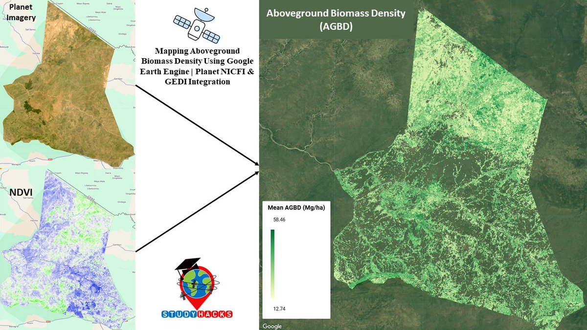
Mapping Aboveground Biomass Density Using
#GoogleEarthEngine | #Planet NICFI & GEDI Integration
Tutorial Link: https://t.co/GuiK7djZkC
Registration Open for 7Day Online Live Training on Google Earth Engine for Remote Sensing & GIS Analysis
Registration
https://t.co/i4EFoxX5HU
Land Cover Classification using Deep Learning Model using Tensorflow || Deep Learning for LULC
Tutorial Link: https://t.co/afjAV97oYL
Registration Info: https://t.co/i4EFoxX5HU
Get Started Today – No Prior Coding Required!
#deeplearning#remotesensing#EarthEngine#GEE
🌎Visualizing the Agricultural Field Boundary dataset - Fields of The World (FTW, https://t.co/bwSwNxilyd) - using #leafmap on @py_cafe ☕️
Check it out: https://t.co/QCrTc2mfqg
@opencholmes
The best-available-pixel (BAP) tool you have been waiting for! Implemented on #GoogleEarthEngine (#GEE). #Landsat
In #GEEBAP can tune composite parameters, create a #timeseries, set area of interest, AND download surface reflectance outcomes!
Try it out:
https://t.co/Aar8Johr43