The #AtlantaAllergyPollenCount for Saturday, March 29 is 14,801. This is the highest recorded count in 35 years!
Tree pollen is in the Extremely High range, weed pollen is in the High range, and mold activity is low. For more info on today's count: https://t.co/iJmeZtBOIQ
Lingering moisture from #Francine continues!
🔴 Today: Periodic rain/storms beginning soon...
🔴 Tomorrow: Locally heavy rain at times.
🟡 Sunday: Becoming a little breezier.
🟡 Monday: A couple of remaining showers.
🟡 Tuesday: Still breezy, but mainly dry.
#GAWX#ATLWX
#Francine is bringing some impacts to the Perimeter!
🔴 Today: Gusts up to 40 mph.
🔴 Tomorrow: Locally heavy rain/storms.
🔴 Saturday: Not as windy, but rain/storms likely.
🟠 Sunday: Trailing rain possible.
🟡 Monday: Some clearing on the way; still mild.
#GAWX#ATLWX
#Francine's outer bands will bear watching tomorrow...
🟡 Today: Dry, but becoming a touch breezier.
🔴 Tomorrow: Rain and gusts to 35 MPH.
🟠 Friday: Cool with scattered rain/storms.
🟠 Saturday: Some storms, but not as breezy.
🟡 Sunday: Trailing shower or two.
#GAWX#ATLWX
Remnants from future #Francine could bring a dose of rain later this week!
🟢 Today: Bright and warm!
🟢 Tomorrow: Mainly sunny, and less humid!
🟡 Wednesday: Becoming cloudy and breezy.
🔴 Thursday: Much cooler and rainy.
🟠 Friday: Cooler, with scattered showers.
#GAWX#ATLWX
Temperatures are backing off a little bit to end the weekend!
🟢 Today: Much drier and breezy!
🟢 Tomorrow: Sunny and spectacular!
🟢 Tuesday: Warm, but breezy in the afternoon!
🟡 Wednesday: Cooler with more clouds.
🟠 Thursday: Start of another rainy pattern...
#GAWX#ATLWX
We're back to a seasonable feel across Metro Atlanta!
🟡 Today: Mainly sunny and warm, but breezy.
🟢 Tomorrow: Cooler and not as humid!
🟢 Monday: Seasonable afternoon!
🟢 Tuesday: Bright with a breeze developing!
🟡 Wednesday: Breezy ahead of our next system...
#GAWX#ATLWX
Rain chances are on the way, but we'll steer clear of the heaviest of it!
🟡 Today: Cooler with some rain later in the day.
🟡 Tomorrow: Warmer, but breezier.
🟢 Sunday: Nice, but breezy!
🟢 Monday: Seasonable and mostly sunny!
🟢 Tuesday: A touch breezy, but dry!
#GAWX#ATLWX
Higher rain chances are moving in to close out the week!
🟡 Today: Mostly cloudy and quite breezy!
🟡 Tomorrow: Cooler with rain at times.
🟡 Saturday: Breezy in the afternoon, but dry!
🟢 Sunday: Back to "10/10" days!
🟢 Monday: Warm with lots of sunshine!
#GAWX#ATLWX
We're cooler and drier for a bit, with one rainy day to come!
🟡 Today: Breezy with an increase in clouds.
🟡 Tomorrow: Small chance of rain late.
🟠 Friday: Cooler with scattered rain.
🟡 Saturday: A little warmer, but becoming dry!
🟢 Sunday: Rather comfortable!
#GAWX#ATLWX
The Wedge™ is in full gear!
🟡 Today: Much breezier (gusts over 25 mph)!
🟡 Tomorrow: Becoming cloudier; still breezy.
🟡 Thursday: Small rain chances late.
🔴 Friday: Cooler with steady (and likely heavy) rain.
🟡 Saturday: Drying out, but still a little breezy!
#GAWX#ATLWX
We're comfortable for Labor Day Monday, but inclement weather is nearby!
🟡 Today: Small rain chance this evening.
🟡 Tomorrow: Much drier, but breezier.
🟡 Wednesday: Gusts up to 25 mph.
🟠 Thursday: Mild, with rain developing.
🟠 Friday: Damp and much cooler...
#GAWX#ATLWX
Labor Day Weekend will be a toasty one!
🟡 Today: Hot, with a nearby storm or two.
🟡 Tomorrow: Scattered storms; still hot.
🟡 Labor Day: Incoming cold front...
🟡 Tuesday: Much cooler, with higher rain chances.
🟡 Wednesday: Back in the 70s (with rain/storms)...
#GAWX#ATLWX
Afternoon and evening storms are more likely today across the #DMV as a backdoor cold front moves through.
Storms that are able to form will be capable of producing isolated damaging wind gusts, small hail, and heavy rainfall.
#DCWX#MDWX#VAWX
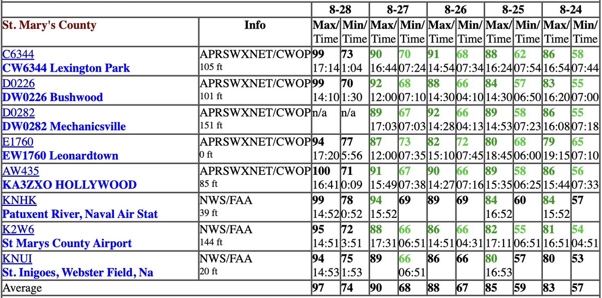
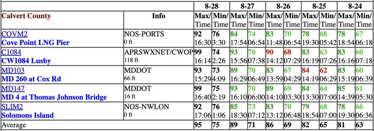
On top of @Reagan_Airport reaching an astonishing high temperature of 101° (by August standards), many spots across #SoMD also got close to the century mark!
Places along the Bay made it into the low-90s, while a few select spots in Charles County climbed towards 100°!
#MDWX
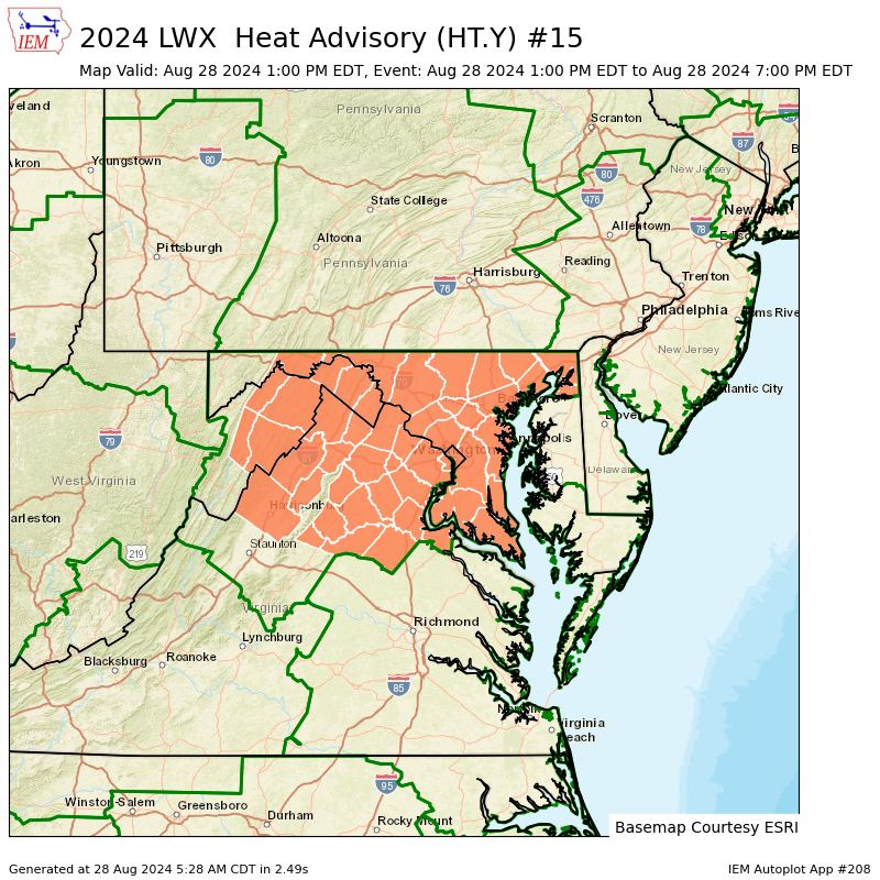
Heat Advisories have been expanded to include all of #SoMD this afternoon and evening!
Afternoon highs should easily reach the mid to upper-90s away from the Bay, with heat index values between 105-110° expected.
#MDWX#SOMD
Another stretch of 90s are here ahead of Labor Day weekend!
🟢 Today: Hot, but not really humid.
🟡 Tomorrow: Hotter and more humid...
🟡 Thursday: Heat index between 100-105°F.
🟡 Friday: A couple of nearby storms.
🟡 Saturday: Not as hot with evening pop-ups...
#GAWX#ATLWX
#DMV: Scattered storms are in the forecast for the afternoon and evening, with a few clusters likely to produce brief heavy rain and isolated strong gusts.
With a NW/SE storm motion, expect storms to get close to the Beltway starting around 2 PM.
#DCWX#MDWX#VAWX
The Wedge™ continues to bring us drier, cooler air for the end of the week!
🟢 Today: Becoming sunnier later in the day.
🟢 Tomorrow: Sunny, but breezy.
🟢 Saturday: Bright and warm!
🟢 Sunday: Also sunny, but warmer!
🟡 Monday: Starting to become humid (again)...
#GAWX#ATLWX