I am elated to announce that I will be the newest Meteorologist at Live 5 News in Charleston, SC! I look forward to working with and learning from a prominent set of meteorologists and newscasters, and I'm excited to continue my journey in the Lowcountry!
@Live5News@LIVE5WEATHER
TROPICS: Things are heating up in the Eastern #Pacific! As of Wednesday, @NHC_Pacific began issuing advisories on Tropical Storm #Amanda - the first named system in the basin this year. Additional disturbances may develop early next week offshore of #Mexico. #TSAmanda#Tropics
WEDNESDAY MORNING: You're going to wake up to temperatures that we have not seen since mid-May! As drier air filters in, temperatures will gradually bottom out in the 50s. Some sheltered locations (especially N/W of the Charleston Tri-County) could briefly dip into the 40s. #SCWX
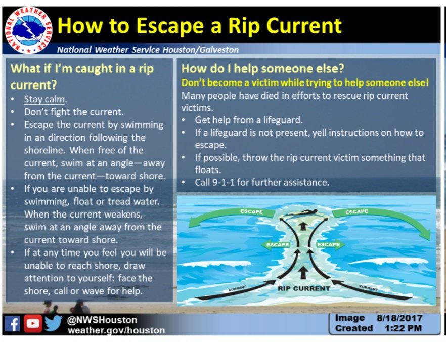
Wednesday is going to be a beautiful day and we will all want to be outside as it’s been kind of dreary. But heads up, beachgoers. There is a HIGH risk of rip currents tomorrow! 🚩🌊 #scwx@Live5News
FIRST ALERT TRAFFIC (11 PM) - We have received tips about an accident on Cottageville Hwy (Hwy 17A) near the intersection of Jenkins Club Rd (Colleton). Additional information will be made available on @Live5News and @Live5Traffic as we learn more information. #CHSTRFC
FIRST ALERT: Wednesday morning's lows will feel more fall-like as a front continues to push southward! Most areas will see temperatures in the 50s (potentially cooler N/W of the Charleston Tri-County) early, followed by afternoon highs near 80°. #SCWX
ON THE ROADS: Prepare to leave out a few minutes early if you're headed to work! Although rainfall will not be as heavy as what was observed on Monday, a few showers - along with one or two steadier pockets - will be possible early. @Live5Weather@Live5News#SCWX#CHSWX
SEVERE THUNDERSTORM WARNING has been issued for parts of Barnwell, Bamberg, Orangeburg, Aiken until 6/02 12:30AM. A Severe Thunderstorm can produce damaging winds and large hail. Take cover!
FIRST ALERT TRAFFIC (10:15 PM) - Barricades have been placed on the exit ramp of the Ashley River Bridge (US-17 NB) to Lockwood Dr due to rising water.
Additional road closures could occur within the coming minutes.
#SCWX@Live5News@Live5Weather@NWSCharlestonSC
BREAKING: A "Flash Flood Warning" is in effect for a large portion of the Charleston Metro until 12:15 AM Tuesday. Rainfall rates, especially between 10-11 PM, could exceed 1-3" per hour, causing additional instances of street and areal flooding. @Live5Weather#SCWX#CHSWX
BREAKING: A "Flash Flood Warning" is in effect for a large portion of the Charleston Metro until 12:15 AM Tuesday. Rainfall rates, especially between 10-11 PM, could exceed 1-3" per hour, causing additional instances of street and areal flooding. @Live5Weather#SCWX#CHSWX
FLASH FLOOD WARNING has been issued for parts of Charleston, Berkeley, Dorchester until 6/02 12:15AM. A Flash Flood Warning means flooding is occurring with additional flooding possible.
FIRST ALERT: Isolated strong thunderstorms remain possible overnight as a cold front dips into the Lowcountry! Through 2 AM Tuesday, storms could produce heavy rainfall and gusty winds. Most of our activity will clear before daybreak Tuesday. #SCWX
FIRST ALERT (7:15 PM) - Our next "main" line of storms are quickly advancing out of the Midlands, and are aimed towards Lake Marion!
Gusts up to 50 MPH will be possible across eastern Orangeburg, western Berkeley and southern Clarendon Counties.
📍Santee State Park
#SCWX
FUTURE TRACKER: Flooding impacts are beginning to ease in our hardest-hit areas from today, but more rain is expected tonight! Broken lines of showers and storms will push through the Lowcountry through at least midnight, producing pockets of heavy rain and gusty winds. #SCWX
UPDATE (6:20 PM) - Although rainfall has mostly ended, rising tide levels will make improvements very slow in the coming hours. Here's a list of our newest closures:
- Fishburne @ Hagood
- Fishburne @ Ashley
- Ogier (near Calhoun)
- Ashley @ Bennett
#SCWX#CHSWX#CHSTRFC
FIRST ALERT TRAFFIC (5:50 PM) - Roadway flooding is underway at numerous spots in Downtown #Charleston.
Calhoun Street (below) is open, but water is covering the entire roadway.
The intersection of King Street and Huger Street is closed.
#SCWX#CHSWX#CHSTRFC
FIRST ALERT TRAFFIC (5:50 PM) - Roadway flooding is underway at numerous spots in Downtown #Charleston.
Calhoun Street (below) is open, but water is covering the entire roadway.
The intersection of King Street and Huger Street is closed.
#SCWX#CHSWX#CHSTRFC
FIRST ALERT (4:50 PM) - A "Flood Advisory" is in effect for portions of Downtown Charleston until 6:45 PM. Thunderstorms across the Charleston Metro have the potential to produce heavy rainfall, which could lead to areas of ponding and isolated flooding. #SCWX#CHSWX
Officers have one lane of Chuck Dawley Blvd. closed on the eastbound side in front of the MUSC offices. Apparent water main break. Waterworks is on the way.