Safety Officer. EKU Grad. Storm Spotter. Weather Geek. Dog Lover. M.S. Safety, Security & Emergency Management. Kentucky Fan 🏀🏈Minnesota Vikings Fan. From KY.
Kyle and I had a really challenging existence for many years. But we luckily took the time to figure out our differences and that was something he instigated with a conversation in his bus around how we each managed our racing teams. I was super eager for us to get on better terms. But it was he who made the effort for that to be possible. We did some media together also to laugh through some of the things we put each other through many years ago. Most recently we had even been discussing him running my Late Model at Wilkesboro this summer. He seemed extremely happy and we had planned to meet up next Thursday to get his seat to the shop. He laughed over the idea of his fans and JRM fans having to cheer in unison during that race.
Kyle was one of the greatest drivers in NASCAR history. No one can deny that. But he was also a father, a husband, brother, son, and a friend to many. My heart is broken for the Busch family. I will never be able to make sense of this loss but I am thankful that we had found a way to become friends.
We are saddened and heartbroken to share the news of the passing of Kyle Busch, a two-time Cup champion and one of our sport's greatest and fiercest drivers. He was 41 years old.
We extend our deepest condolences to the Busch family, Richard Childress Racing and the entire motorsports community.
HISTORIC PATTERN FOR TORNADOES POSSIBLE second half of May
Live emergency update on a multi-day #tornado outbreak threat across the central U.S. from Oklahoma to Wisconsin starting this weekend! This tornado outbreak sequence will peak on Sunday-Monday across Kansas and Oklahoma east of a dry line. A massive trough-ridge pattern is forecast to evolve across North America, which will set the stage for volatile warm sectors with #tornado potential day-after-day.
We are gearing up the Dominator 3 for full-blown #tornado intercept mode.
Stay tuned!
This man ordered 165 pool noodles from Walmart. When they arrived through FedEx, there was a little surprise. They had been individually boxed.
You just know that Walmart employee is paid by the hour. 😆😆
And the FedEx driver got to unload an entire truck in one place, and they weren’t heavy.
See the sandpapering effect?!
The massive wedge #tornado yesterday was a violent vortex likely at least EF4.
Classic Dixie Alley grinder
#stormchasing#Dominator
This supercell was so ridiculous, it forced the issuance of FOUR tornado emergencies as it tracked 175 miles in southern MS for nearly 5 hours. Several fatalities from its violent tornado family unfortunately occurred; may they rest in peace.
Here's a detailed video timeline.
Drone video reveals extreme forest destruction in Franklin County southeast of Roxie, Mississippi after a significant tornado tore through the area last night. A Tornado Emergency was in effect at the time, and you can see just how intense it was in this area. I estimate the damage path was nearly a mile wide here…
@ryanhallyall@WxWiseApp
#Missippi #Tornado #SevereWeather
🚨#BREAKING: A Tornado Emergency has been issued as an extremely violent, life-threatening tornado is on the ground
📌#Brookhaven | #Mississippi
A Tornado Emergency has been issued by the National Weather Service for a rare, catastrophic, and life-threatening situation as a confirmed, extremely large and violent tornado is currently on the ground causing devastating damage across parts of Mississippi. Residents in Brookhaven, Bude, and Bogue Chitto need to take shelter now! This is an extremely dangerous and rapidly evolving situation with conditions continuing to worsen as the tornado is capable of complete destruction. Large debris is airborne, deadly wind speeds are occurring within the storm, and lives are at immediate risk. If you are anywhere near this tornado, TAKE COVER NOW! This is a life-threatening emergency.
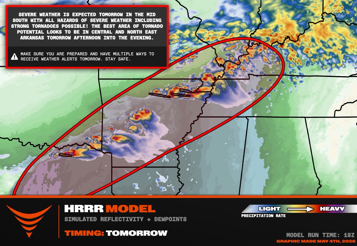
We are watching a threat of supercells capable of dropping gorilla hail with an isolated #tornado threat across Arkansas into western Kentucky back into northeastern Texas. The #tornado threat should be maximized across central and northern Arkansas along a terrain enforced warm frontal zone.
May 3, 1999: Live from Chopper 4. 🚁
Jim Gardner and KFOR Chopper 4 provided the world with the most iconic aerial footage in history during the May 3, 1999, outbreak.
His reporting from Chopper 4 gave viewers and emergency personnel a vital, real-time look at the F5’s path through Bridge Creek, Moore, Del City, and Tinker AFB.
27 years later, this footage remains the gold standard for storm coverage.
Pilot: @jimintheair
Credit: KFOR-TV
#okwx #oklahoma
On this day, 27 years ago, we chased what is well-known as the strongest #tornado in History.
This shows the F5 tornado near peak intensity, just after devastating the community of Bridge Creek, Oklahoma.
Aa freshman meteorology students at OU, we stupidly abandoned our Geo Tracker and took shelter under an overpass. Research was published that overpasses can accelerate the tornadic wind and be even more dangerous.
We then saw the terrible devastation in Moore, Oklahoma with horses wandering down the highway and people emerging from their destroyed homes. Over 50 people lost their lives from the May 3, 1999 tornado outbreak.
There was another massive violent tornado with a supercell to the north near Mulhall, Oklahoma that peaked after sunset.
The tornado outbreak was still going when I woke up for class the next morning at 7 am.
This is a day that Oklahomans will never forget. Enjoy the nice weather this May 3,
BREAKING: Golden Tempo wins the Kentucky Derby after coming from dead last
His rider, Jose Ortiz, is a devout Christian and shared this Bible verse before the race
“I can do all things through Christ which strengtheneth me”
Nothing is impossible with God. ✝️