*Mostly Tracking Weather in the Western Pacific.
*I've been Tracking Storms Since Year 2017.
*Making Updates on the Latest Activity around the WesternPacific
TSR Forecast is out for the 2026 Pacific Typhoon Season! Issued on May 11th, posting a bit late on this. They are expecting a well above average season with 27 Tropical Storms, 18 Typhoons and 11 Major Typhoons C3+. This year is contender with Top tier +ENSO events 1997/2015/1982
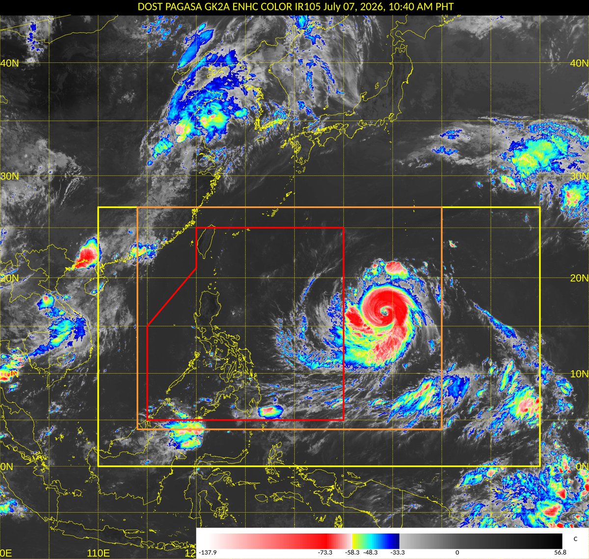
Super Typhoon #Bavi (pre-#IndayPH) has regained super typhoon status on the Joint Typhoon Warning Center (JTWC) scale after completing an eyewall replacement cycle (ERC) earlier today. ⚠️
Meanwhile, the Japan Meteorological Agency (JMA) reports that the gale-force wind diameter of STY Bavi has reached 1,300 kilometers, making it the largest tropical cyclone in the Western Pacific (WPAC) basin so far this year, surpassing STY #Sinlaku.
JMA (JP): 100 kts (~185 km/h) [10-min] {Very strong}
PAGASA (PH): 100 kts (~185 km/h) [10-min] {Super typhoon}
JTWC (US): 130 kts (~240 km/h) [1-min] {Category 4}
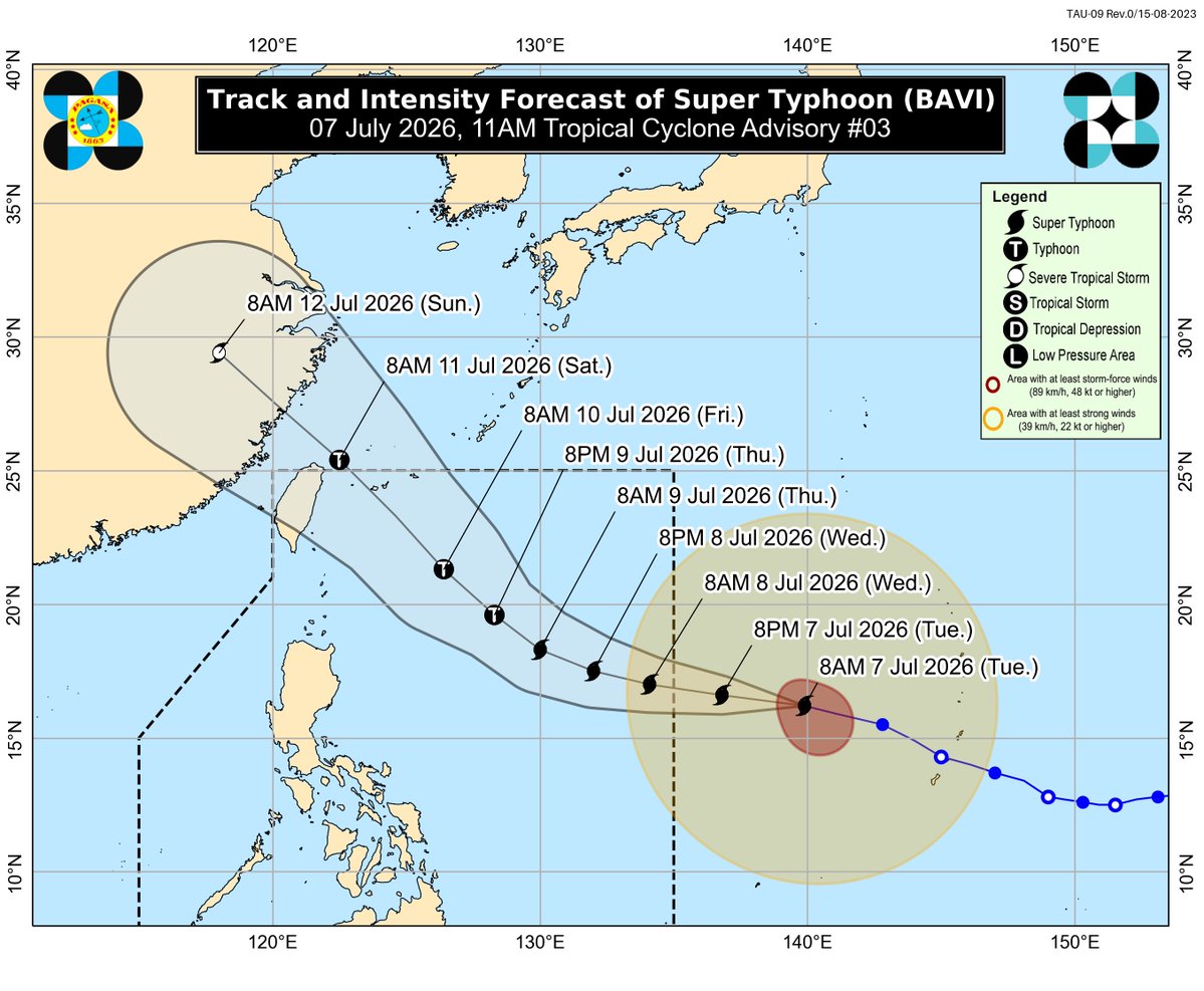
The latest forecast track from JMA shows a westward motion over the next 24 hours before the system turns sharply northwestward as the subtropical ridge to its northeast becomes the primary steering mechanism.
Beginning late tomorrow, July 8, increasing wind shear is expected to gradually weaken the system as it approaches Taiwan and the Ryukyu Islands.
Meanwhile, based on satellite imagery, the extension or trough of STY Bavi, associated with the Southwest Monsoon (#HabagatPH) appears to be reaching Eastern Visayas and Catanduanes.
📷: Himawari-9 via Dapiya, RAMMB-CIRA, JMA via WNP, F16 SSMIS via CIMSS
Typhoon Bavi has been undergoing an eyewall replacement cycle for ~24 hours now with the inner eyewall finally nearly gone and and impressive ~100 mile wide secondary eyewall becoming dominant with a very symmetric donut
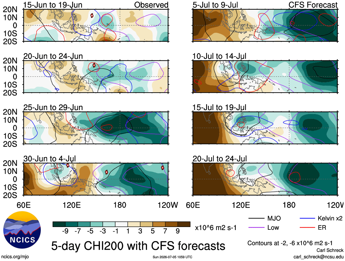
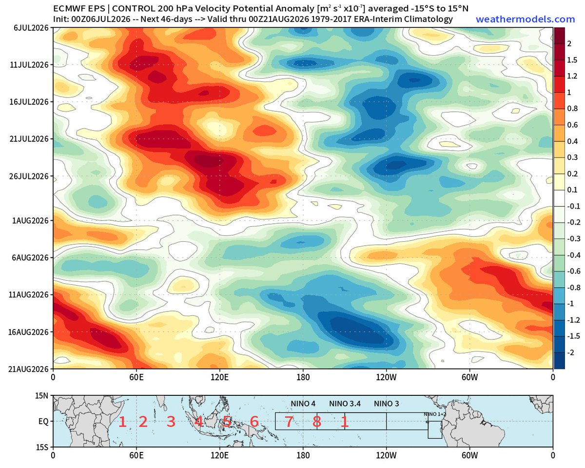
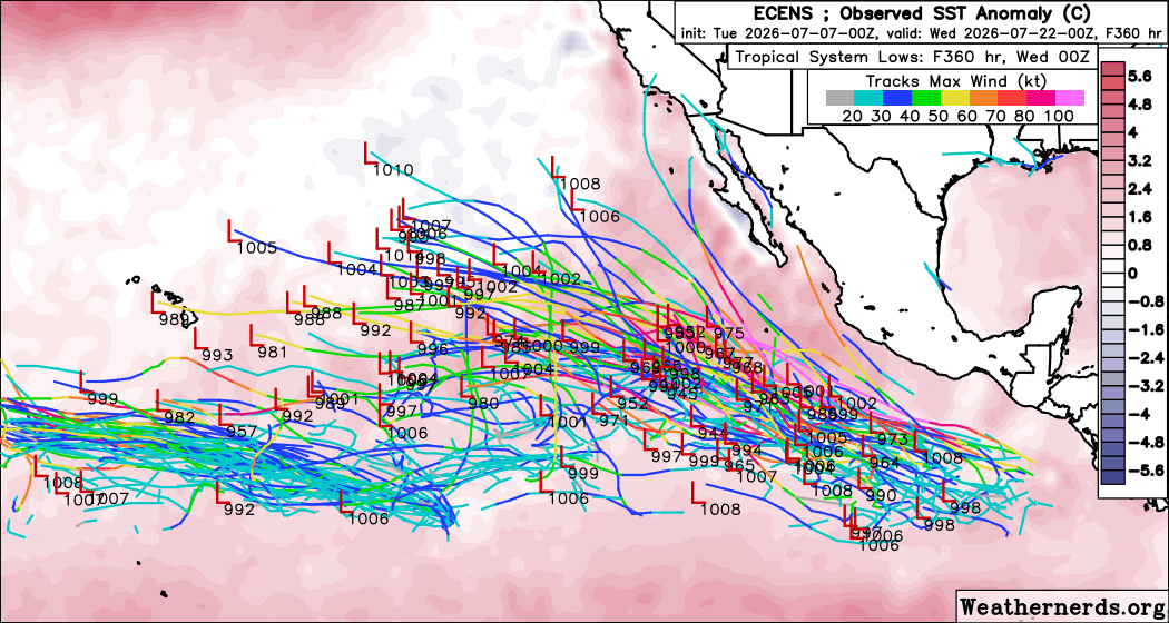
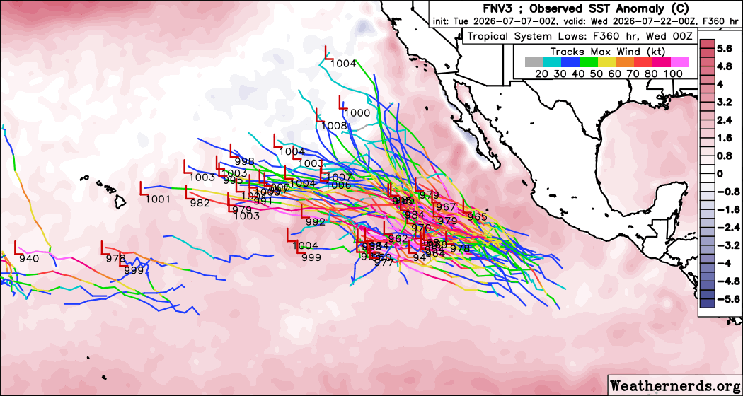
Seeing some indications in modeling that the East Pacific will awaken from its early-season slumber and start to get active in the next 2 weeks. An MJO pulse will constructively interfere with the developing El Niño circulation and favor lots of convection in the area. And with record SST across much of the basin, there will be plenty of fuel for anything that does form.
Crazy to think 24 hours ago it was raging winds from Super Typhoon Bavi. Today it is back to your typical tropical paradise. The island of Saipan truly dodged a bullet with Bavi, but our thoughts are for those on Rota.
#Saipan#Bavi#Typhoon
TROPICAL CYCLONE ADVISORY NR. 3
Super Typhoon BAVI
Issued at 11:00 AM, 07 July 2026
Valid for broadcast until the next advisory at 11:00 PM today.
SUPER TYPHOON BAVI SLIGHTLY WEAKENS AS IT CONTINUES TO MOVE WEST NORTHWESTWARD OUTSIDE PAR.
Link:https://t.co/Qn10X0QYBE
Typhoon #Bavi to enter the Philippine Area of Responsibility (PAR) within the next 24 hours as a super typhoon on the PAGASA intensity scale.
Meanwhile, it may (slightly) re-intensify into a super typhoon and a violent typhoon under the Joint Typhoon Warning Center (JTWC) and Japan Meteorological Agency (JMA) classification systems, respectively.
JMA (JP): 100 kts (~185 km/h) [10-min] {Very strong}
PAGASA (PH): 100 kts (~185 km/h) [10-min] {Super typhoon}
JTWC (US): 125 kts (~230 km/h) [1-min] {Category 4}
However, the slight intensification is expected to be short-lived before a general weakening trend begins tomorrow, July 8. Despite the effects of mid- to lower-level wind shear and some dry air entrainment, strong upper-level westerly outflow continues to ventilate the system, supported by other favorable factors such as high ocean heat content (OHC) and very warm sea-surface temperatures (SSTs).
Also, due to the storm's slightly slower movement as an eyewall replacement cycle (ERC) takes place, the eye of STY Bavi is expected to enter PAR tomorrow morning.
Despite the weakening trend, the storm is expected to continue expanding in size once the ERC is complete. Combined with the effects of strong westerly flow and a positive BSISO index, the enhanced Southwest Monsoon (#HabagatPH) will bring widespread heavy rainfall across the Philippines beginning tomorrow and lasting into early next week.
For the official advisories, kindly follow @dost_pagasa.
📷: JMA via WNP, PolarWX, CIMSS, Himawari-9 via Dapiya
Layover. En route to play some Island Roulette in East Asia. Expecting a big, fat, truck-tire Cat 3, probably in the lower Ryukyu Islands of #Japan. But I'll be staging in #Taiwan for convenience. Kicking off 2026 chase season with #Typhoon#BAVI.
BREAKING: Super Typhoon #Bavi is no longer classified as a super typhoon by the Joint Typhoon Warning Center (JTWC), having weakened to 125 kts (~225 km/h), equivalent to a Category 4 typhoon.
TY Bavi remained at super typhoon intensity for 78 consecutive hours, making it the longest-lasting super typhoon in the Western Pacific (WPAC) basin since STY #Yutu (2018).
Note: Under the JTWC (US) scale, a tropical cyclone is classified as a "super typhoon" when its 1-min average sustained winds reach at least 130 kts (240 km/h; 150 mph).
📷: Himawari-9 via CyclonicWX
#Bavi has fallen off and rightfully so given the current EWRC situation. You can see the moat around the inner eyewall as the secondary one forms & starts to become dominant. Bavi will be hitting another Super Typhoon peak on its way to Asia.
#tropicswx
𝗦𝗨𝗡𝗥𝗜𝗦𝗘 𝗢𝗩𝗘𝗥 𝗦𝗨𝗣𝗘𝗥 𝗧��𝗣𝗛𝗢𝗢𝗡 𝗕𝗔𝗩𝗜 𝗔𝗡𝗗 𝗧𝗛𝗘 𝗣𝗛𝗜𝗟𝗜𝗣𝗣𝗜𝗡𝗘𝗦🌅
Here's the latest satellite image of massive Super Typhoon #Bavi (pre-#IndayPH) as it churns over the Philippine Sea this morning. The Philippine archipelago lies to the west of the powerful cyclone.
Super Typhoon Bavi has expanded further, with its circulation now spanning approximately 1,120 kilometers in diameter, based on the 30-knot wind radius estimated by the Japan Meteorological Agency (JMA).
Here's our 5:00 AM Update for Bavi: https://t.co/K91vu30sqG
Based on recent satellite imagery, Super Typhoon #Bavi appears to have reached its peak intensity as it meanders across the Philippine Sea. It has already weakened to a Category 4 storm but continues to maintain super typhoon intensity by the Joint Typhoon Warning Center (JTWC) and remains at the "violent" intensity of the Japan Meteorological Agency (JMA).
JMA (JP): 105 kts (~195 km/h) [10-min] {Violent}
PAGASA (PH): 105 kts (~195 km/h) [10-min] {Super typhoon}
JTWC (US): 135 kts (~250 km/h) [1-min] {Category 4}
There are two main reasons for its gradual weakening. First, an eyewall replacement cycle (ERC) is underway, as seen in microwave imagery, showing the collapse of the inner eyewall as it competes with the outer eyewall. The eye has cooled down but still warm at 12.5°C, with cold cloud tops reaching -80°C.
Second, moderate easterly wind shear is affecting the southeastern quadrant of the storm, with most of the convective activity now concentrated in the western semicircle due to strong westerly outflow.
Both DOST-PAGASA and the Joint Typhoon Warning Center (JTWC) forecast STY Bavi to maintain super typhoon intensity over the next 48 hours while undergoing an eyewall replacement cycle (ERC) and fighting with moderate wind shear.
Once the ERC is complete, STY Bavi is expected to expand in size once again. PAGASA also indicates that the eastern portion of the Philippines may be placed under Tropical Cyclone Wind Signals as the storm's wind field expands — currently at 1,100 km of gale-wind diameter per JMA.
A landfall in the Philippines remains LESS LIKELY. However, due to the storm's persistent large circulation and its enhancement of the Southwest Monsoon (#HabagatPH), gusty winds may be experienced across much of the country beginning today.
For the official updates and advisories, please follow @dost_pagasa.
📷: Himawari-9 via Dapiya, F17 SSMIS via RAMMB, CIMSS, PAGASA
The current situation in the Eastern Pacific. Credit to @ViridWx
Also, I do think this is a rare backloaded EPAC season. After July 20-25 I think it’ll start to produce.
After devastating Rota, Super Typhoon #BAVI appears to be undergoing an eyewall replacement cycle — evident by the degradation of the inner core and shrinking eye.
This will weaken BAVI slightly and make it a much larger typhoon. Soon after, we begin turning our attention towards #Taiwan and #China.
Super Typhoon Bavi seems to be finally progressing deeper into the eyewall replacement cycle that arguably began over 36 hours ago. The wobble of the eye is becoming more and more pronounced and the CDO is finally exhibiting the tell-tale signs of eyewall replacement more clearly
Super Typhoon #Bavi is now the longest-lasting super typhoon in the Western Pacific (WPAC) basin of the current decade, sustaining super typhoon intensity for 66 hours and counting.
It has officially surpassed STY Mawar (2023) and is now the longest-lasting super typhoon since STY #Hagibis (2019).
Note: Under the JTWC (US) scale, a tropical cyclone is classified as a "super typhoon" when its 1-min average sustained winds reach at least 130 kts (240 km/h; 150 mph).
📷: Himawari-9 via Dapiya
In the wake of #Bavi, there can be additional tropical development north of #Micronesia and in the vicinity of the #Mariana Islands from Friday into early next week.
This is what a +3.9˚C El Niño could look like at its peak in December, according to new ECMWF data.
It would be the strongest El Niño on record by a wide margin.


![MattWestPacWX's tweet photo. Super Typhoon #Bavi (pre-#IndayPH) has regained super typhoon status on the Joint Typhoon Warning Center (JTWC) scale after completing an eyewall replacement cycle (ERC) earlier today. ⚠️
Meanwhile, the Japan Meteorological Agency (JMA) reports that the gale-force wind diameter of STY Bavi has reached 1,300 kilometers, making it the largest tropical cyclone in the Western Pacific (WPAC) basin so far this year, surpassing STY #Sinlaku.
JMA (JP): 100 kts (~185 km/h) [10-min] {Very strong}
PAGASA (PH): 100 kts (~185 km/h) [10-min] {Super typhoon}
JTWC (US): 130 kts (~240 km/h) [1-min] {Category 4}
The latest forecast track from JMA shows a westward motion over the next 24 hours before the system turns sharply northwestward as the subtropical ridge to its northeast becomes the primary steering mechanism.
Beginning late tomorrow, July 8, increasing wind shear is expected to gradually weaken the system as it approaches Taiwan and the Ryukyu Islands.
Meanwhile, based on satellite imagery, the extension or trough of STY Bavi, associated with the Southwest Monsoon (#HabagatPH) appears to be reaching Eastern Visayas and Catanduanes.
📷: Himawari-9 via Dapiya, RAMMB-CIRA, JMA via WNP, F16 SSMIS via CIMSS](https://pbs.twimg.com/media/HMoKWQEaMAAUGTx.png)







![MattWestPacWX's tweet photo. Typhoon #Bavi to enter the Philippine Area of Responsibility (PAR) within the next 24 hours as a super typhoon on the PAGASA intensity scale.
Meanwhile, it may (slightly) re-intensify into a super typhoon and a violent typhoon under the Joint Typhoon Warning Center (JTWC) and Japan Meteorological Agency (JMA) classification systems, respectively.
JMA (JP): 100 kts (~185 km/h) [10-min] {Very strong}
PAGASA (PH): 100 kts (~185 km/h) [10-min] {Super typhoon}
JTWC (US): 125 kts (~230 km/h) [1-min] {Category 4}
However, the slight intensification is expected to be short-lived before a general weakening trend begins tomorrow, July 8. Despite the effects of mid- to lower-level wind shear and some dry air entrainment, strong upper-level westerly outflow continues to ventilate the system, supported by other favorable factors such as high ocean heat content (OHC) and very warm sea-surface temperatures (SSTs).
Also, due to the storm's slightly slower movement as an eyewall replacement cycle (ERC) takes place, the eye of STY Bavi is expected to enter PAR tomorrow morning.
Despite the weakening trend, the storm is expected to continue expanding in size once the ERC is complete. Combined with the effects of strong westerly flow and a positive BSISO index, the enhanced Southwest Monsoon (#HabagatPH) will bring widespread heavy rainfall across the Philippines beginning tomorrow and lasting into early next week.
For the official advisories, kindly follow @dost_pagasa.
📷: JMA via WNP, PolarWX, CIMSS, Himawari-9 via Dapiya](https://pbs.twimg.com/media/HMl-lvoaQAASqkn.jpg)
![MattWestPacWX's tweet photo. Typhoon #Bavi to enter the Philippine Area of Responsibility (PAR) within the next 24 hours as a super typhoon on the PAGASA intensity scale.
Meanwhile, it may (slightly) re-intensify into a super typhoon and a violent typhoon under the Joint Typhoon Warning Center (JTWC) and Japan Meteorological Agency (JMA) classification systems, respectively.
JMA (JP): 100 kts (~185 km/h) [10-min] {Very strong}
PAGASA (PH): 100 kts (~185 km/h) [10-min] {Super typhoon}
JTWC (US): 125 kts (~230 km/h) [1-min] {Category 4}
However, the slight intensification is expected to be short-lived before a general weakening trend begins tomorrow, July 8. Despite the effects of mid- to lower-level wind shear and some dry air entrainment, strong upper-level westerly outflow continues to ventilate the system, supported by other favorable factors such as high ocean heat content (OHC) and very warm sea-surface temperatures (SSTs).
Also, due to the storm's slightly slower movement as an eyewall replacement cycle (ERC) takes place, the eye of STY Bavi is expected to enter PAR tomorrow morning.
Despite the weakening trend, the storm is expected to continue expanding in size once the ERC is complete. Combined with the effects of strong westerly flow and a positive BSISO index, the enhanced Southwest Monsoon (#HabagatPH) will bring widespread heavy rainfall across the Philippines beginning tomorrow and lasting into early next week.
For the official advisories, kindly follow @dost_pagasa.
📷: JMA via WNP, PolarWX, CIMSS, Himawari-9 via Dapiya](https://pbs.twimg.com/media/HMl-ktSbYAANWim.jpg)
![MattWestPacWX's tweet photo. Typhoon #Bavi to enter the Philippine Area of Responsibility (PAR) within the next 24 hours as a super typhoon on the PAGASA intensity scale.
Meanwhile, it may (slightly) re-intensify into a super typhoon and a violent typhoon under the Joint Typhoon Warning Center (JTWC) and Japan Meteorological Agency (JMA) classification systems, respectively.
JMA (JP): 100 kts (~185 km/h) [10-min] {Very strong}
PAGASA (PH): 100 kts (~185 km/h) [10-min] {Super typhoon}
JTWC (US): 125 kts (~230 km/h) [1-min] {Category 4}
However, the slight intensification is expected to be short-lived before a general weakening trend begins tomorrow, July 8. Despite the effects of mid- to lower-level wind shear and some dry air entrainment, strong upper-level westerly outflow continues to ventilate the system, supported by other favorable factors such as high ocean heat content (OHC) and very warm sea-surface temperatures (SSTs).
Also, due to the storm's slightly slower movement as an eyewall replacement cycle (ERC) takes place, the eye of STY Bavi is expected to enter PAR tomorrow morning.
Despite the weakening trend, the storm is expected to continue expanding in size once the ERC is complete. Combined with the effects of strong westerly flow and a positive BSISO index, the enhanced Southwest Monsoon (#HabagatPH) will bring widespread heavy rainfall across the Philippines beginning tomorrow and lasting into early next week.
For the official advisories, kindly follow @dost_pagasa.
📷: JMA via WNP, PolarWX, CIMSS, Himawari-9 via Dapiya](https://pbs.twimg.com/media/HMl-ggta4AA321B.png)


![MattWestPacWX's tweet photo. Based on recent satellite imagery, Super Typhoon #Bavi appears to have reached its peak intensity as it meanders across the Philippine Sea. It has already weakened to a Category 4 storm but continues to maintain super typhoon intensity by the Joint Typhoon Warning Center (JTWC) and remains at the "violent" intensity of the Japan Meteorological Agency (JMA).
JMA (JP): 105 kts (~195 km/h) [10-min] {Violent}
PAGASA (PH): 105 kts (~195 km/h) [10-min] {Super typhoon}
JTWC (US): 135 kts (~250 km/h) [1-min] {Category 4}
There are two main reasons for its gradual weakening. First, an eyewall replacement cycle (ERC) is underway, as seen in microwave imagery, showing the collapse of the inner eyewall as it competes with the outer eyewall. The eye has cooled down but still warm at 12.5°C, with cold cloud tops reaching -80°C.
Second, moderate easterly wind shear is affecting the southeastern quadrant of the storm, with most of the convective activity now concentrated in the western semicircle due to strong westerly outflow.
Both DOST-PAGASA and the Joint Typhoon Warning Center (JTWC) forecast STY Bavi to maintain super typhoon intensity over the next 48 hours while undergoing an eyewall replacement cycle (ERC) and fighting with moderate wind shear.
Once the ERC is complete, STY Bavi is expected to expand in size once again. PAGASA also indicates that the eastern portion of the Philippines may be placed under Tropical Cyclone Wind Signals as the storm's wind field expands — currently at 1,100 km of gale-wind diameter per JMA.
A landfall in the Philippines remains LESS LIKELY. However, due to the storm's persistent large circulation and its enhancement of the Southwest Monsoon (#HabagatPH), gusty winds may be experienced across much of the country beginning today.
For the official updates and advisories, please follow @dost_pagasa.
📷: Himawari-9 via Dapiya, F17 SSMIS via RAMMB, CIMSS, PAGASA](https://pbs.twimg.com/media/HMlNvbObMAATL3F.jpg)
![MattWestPacWX's tweet photo. Based on recent satellite imagery, Super Typhoon #Bavi appears to have reached its peak intensity as it meanders across the Philippine Sea. It has already weakened to a Category 4 storm but continues to maintain super typhoon intensity by the Joint Typhoon Warning Center (JTWC) and remains at the "violent" intensity of the Japan Meteorological Agency (JMA).
JMA (JP): 105 kts (~195 km/h) [10-min] {Violent}
PAGASA (PH): 105 kts (~195 km/h) [10-min] {Super typhoon}
JTWC (US): 135 kts (~250 km/h) [1-min] {Category 4}
There are two main reasons for its gradual weakening. First, an eyewall replacement cycle (ERC) is underway, as seen in microwave imagery, showing the collapse of the inner eyewall as it competes with the outer eyewall. The eye has cooled down but still warm at 12.5°C, with cold cloud tops reaching -80°C.
Second, moderate easterly wind shear is affecting the southeastern quadrant of the storm, with most of the convective activity now concentrated in the western semicircle due to strong westerly outflow.
Both DOST-PAGASA and the Joint Typhoon Warning Center (JTWC) forecast STY Bavi to maintain super typhoon intensity over the next 48 hours while undergoing an eyewall replacement cycle (ERC) and fighting with moderate wind shear.
Once the ERC is complete, STY Bavi is expected to expand in size once again. PAGASA also indicates that the eastern portion of the Philippines may be placed under Tropical Cyclone Wind Signals as the storm's wind field expands — currently at 1,100 km of gale-wind diameter per JMA.
A landfall in the Philippines remains LESS LIKELY. However, due to the storm's persistent large circulation and its enhancement of the Southwest Monsoon (#HabagatPH), gusty winds may be experienced across much of the country beginning today.
For the official updates and advisories, please follow @dost_pagasa.
📷: Himawari-9 via Dapiya, F17 SSMIS via RAMMB, CIMSS, PAGASA](https://pbs.twimg.com/media/HMlNsH9bgAA0Ftt.png)


![MattWestPacWX's tweet photo. Super Typhoon #Bavi (pre-#IndayPH) has regained super typhoon status on the Joint Typhoon Warning Center (JTWC) scale after completing an eyewall replacement cycle (ERC) earlier today. ⚠️
Meanwhile, the Japan Meteorological Agency (JMA) reports that the gale-force wind diameter of STY Bavi has reached 1,300 kilometers, making it the largest tropical cyclone in the Western Pacific (WPAC) basin so far this year, surpassing STY #Sinlaku.
JMA (JP): 100 kts (~185 km/h) [10-min] {Very strong}
PAGASA (PH): 100 kts (~185 km/h) [10-min] {Super typhoon}
JTWC (US): 130 kts (~240 km/h) [1-min] {Category 4}
The latest forecast track from JMA shows a westward motion over the next 24 hours before the system turns sharply northwestward as the subtropical ridge to its northeast becomes the primary steering mechanism.
Beginning late tomorrow, July 8, increasing wind shear is expected to gradually weaken the system as it approaches Taiwan and the Ryukyu Islands.
Meanwhile, based on satellite imagery, the extension or trough of STY Bavi, associated with the Southwest Monsoon (#HabagatPH) appears to be reaching Eastern Visayas and Catanduanes.
📷: Himawari-9 via Dapiya, RAMMB-CIRA, JMA via WNP, F16 SSMIS via CIMSS](https://pbs.twimg.com/media/HMoKZ4OaQAAMh3j.png)


![MattWestPacWX's tweet photo. Typhoon #Bavi to enter the Philippine Area of Responsibility (PAR) within the next 24 hours as a super typhoon on the PAGASA intensity scale.
Meanwhile, it may (slightly) re-intensify into a super typhoon and a violent typhoon under the Joint Typhoon Warning Center (JTWC) and Japan Meteorological Agency (JMA) classification systems, respectively.
JMA (JP): 100 kts (~185 km/h) [10-min] {Very strong}
PAGASA (PH): 100 kts (~185 km/h) [10-min] {Super typhoon}
JTWC (US): 125 kts (~230 km/h) [1-min] {Category 4}
However, the slight intensification is expected to be short-lived before a general weakening trend begins tomorrow, July 8. Despite the effects of mid- to lower-level wind shear and some dry air entrainment, strong upper-level westerly outflow continues to ventilate the system, supported by other favorable factors such as high ocean heat content (OHC) and very warm sea-surface temperatures (SSTs).
Also, due to the storm's slightly slower movement as an eyewall replacement cycle (ERC) takes place, the eye of STY Bavi is expected to enter PAR tomorrow morning.
Despite the weakening trend, the storm is expected to continue expanding in size once the ERC is complete. Combined with the effects of strong westerly flow and a positive BSISO index, the enhanced Southwest Monsoon (#HabagatPH) will bring widespread heavy rainfall across the Philippines beginning tomorrow and lasting into early next week.
For the official advisories, kindly follow @dost_pagasa.
📷: JMA via WNP, PolarWX, CIMSS, Himawari-9 via Dapiya](https://pbs.twimg.com/media/HMmAZgTaYAA3N2o.jpg)

![MattWestPacWX's tweet photo. Based on recent satellite imagery, Super Typhoon #Bavi appears to have reached its peak intensity as it meanders across the Philippine Sea. It has already weakened to a Category 4 storm but continues to maintain super typhoon intensity by the Joint Typhoon Warning Center (JTWC) and remains at the "violent" intensity of the Japan Meteorological Agency (JMA).
JMA (JP): 105 kts (~195 km/h) [10-min] {Violent}
PAGASA (PH): 105 kts (~195 km/h) [10-min] {Super typhoon}
JTWC (US): 135 kts (~250 km/h) [1-min] {Category 4}
There are two main reasons for its gradual weakening. First, an eyewall replacement cycle (ERC) is underway, as seen in microwave imagery, showing the collapse of the inner eyewall as it competes with the outer eyewall. The eye has cooled down but still warm at 12.5°C, with cold cloud tops reaching -80°C.
Second, moderate easterly wind shear is affecting the southeastern quadrant of the storm, with most of the convective activity now concentrated in the western semicircle due to strong westerly outflow.
Both DOST-PAGASA and the Joint Typhoon Warning Center (JTWC) forecast STY Bavi to maintain super typhoon intensity over the next 48 hours while undergoing an eyewall replacement cycle (ERC) and fighting with moderate wind shear.
Once the ERC is complete, STY Bavi is expected to expand in size once again. PAGASA also indicates that the eastern portion of the Philippines may be placed under Tropical Cyclone Wind Signals as the storm's wind field expands — currently at 1,100 km of gale-wind diameter per JMA.
A landfall in the Philippines remains LESS LIKELY. However, due to the storm's persistent large circulation and its enhancement of the Southwest Monsoon (#HabagatPH), gusty winds may be experienced across much of the country beginning today.
For the official updates and advisories, please follow @dost_pagasa.
📷: Himawari-9 via Dapiya, F17 SSMIS via RAMMB, CIMSS, PAGASA](https://pbs.twimg.com/media/HMlNyAMa8AANtcB.jpg)