TORNADO OUTBREAK central Illinois to Arkansas including the St Louis Metro!!
Multiple rounds of supercells capable of producing strong-to-violent tornadoes will be possible starting as early as 3-4 pm.
Millions of people could be at risk from this severe weather outbreak.
#stormchasing #Dominator
My thoughts for Middle TN on Monday
Lots of talk about it, but I think we are narrowing down to a *possible* outcome here.
I think it is likely that a strong QLCS will develop off to the west in parts of Arkansas and Missouri and move east into the area. The overall timing of this system has slowed down significantly, hence why we won't be dealing with the significant tornado side of things.
Right now, models are consistent in showing a locally favorable area for QLCS maintenance for areas along and WEST of i65 before it starts to lose steam after crossing the interstate.
So as of now, I would take this seriously due to lingering ice storm + drought impacts. There are some pretty weak trees out there. Shoot, half the city lost power the other weak it felt like from a surprise and relatively unorganized line of storms.
Below is the latest Euro model's thoughts. It has ensemble support as well. I am interested to see if high res guidance continues this look.
SPC upgraded to a Moderate Risk with significant tornado probabilities across Illinois and Indiana. They're expecting multiple strong to intense tornadoes tonight, EF2 to EF3+.
My 24/7 stream is tracking everything live right now. I'll be going live myself in a few hours.
https://t.co/DWdrirvZIy
I know you're frustrated, throw that out of the window. The Freezing Rain threat late tonight - Sunday is LIFE THREATENING. Please take these last few hours before the ice hits and be sure to have all of your back up plans and shelter locations ironed out.
*** Emergency Broadcast is tentatively scheduled for 7:30pm ET. Please tune in if you're in any of the colored locations on the map. - George
I am LIVE NOW breaking down the winter storm slamming Kentucky. A sharp cutoff between heavy snow and a crippling ice storm is happening tonight. Do not get caught off guard. Tune into the stream to see exactly when the transition happens in your town. https://t.co/LuYHIsnnzr
A thread of videos from today’s flight into Hurricane Melissa
In this first one we are entering from the southeast just after sunrise and the bright arc on the far northwest eye wall is the light just beginning to make it over the top from behind us.
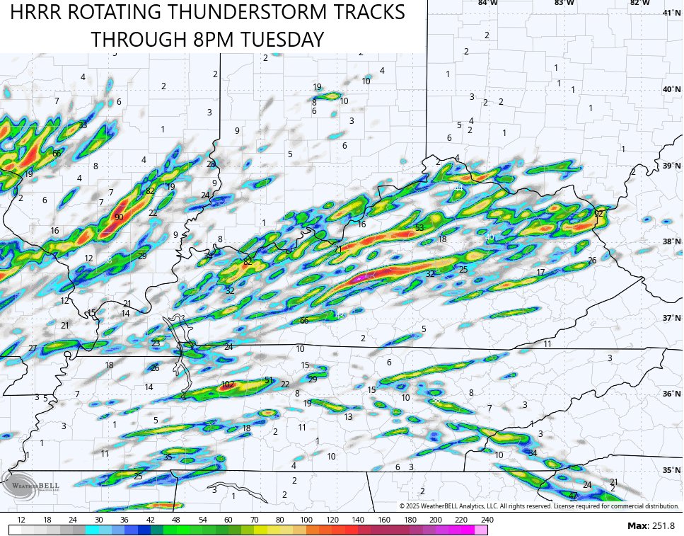
This isn't good. The latest HRRR Model shows the potential for rotating thunderstorms across Kentucky Tuesday. This is where the model thinks those show up. #kywx
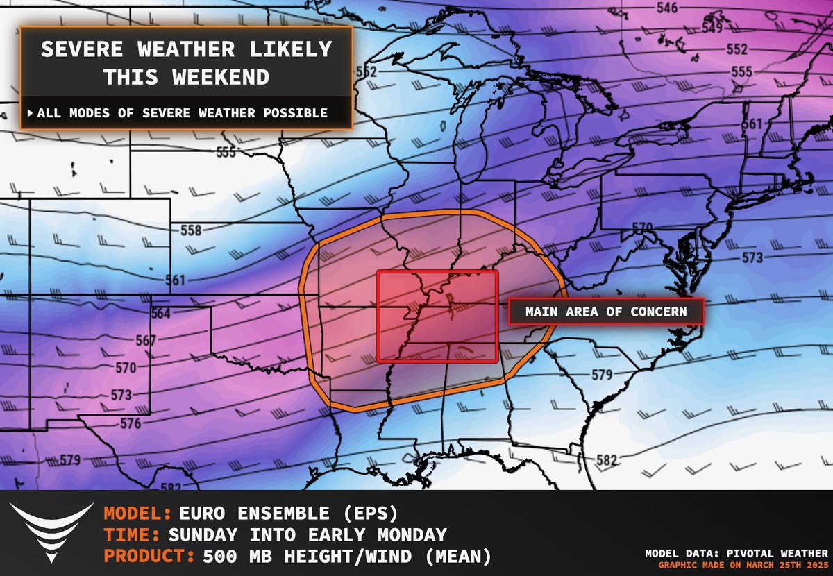
TORNADO OUTBREAK possible this weekend, peaking on Sunday PM into across the heart of Dixie Alley including Memphis to Nashville areas.
We define a tornado outbreak as 6 more tornadoes across a region during a 24 hour period. All hazards will likely be possible ahead of this large trough and warm sector. The SPC has issued one of the more expansive risk areas ever for Sunday.
Stay tuned! Thank you to @PettusWX for the incredible graphics
The HRRR is very concerning for Saturday and Saturday night across central and eastern Kentucky. Severe storms, damaging winds and flooding rains are all possible. The rainfall forecast is ugly. #kywx
Jordy Rowland forwarded this video to a good friend from earlier this afternoon. The wind is rippin’ in the Panhandle. This particular video is out of Nazareth, just SW of Amarillo. #etxwx#txwx
These next two days are going to be a big deal across the central/eastern U.S.
Be sure to stay tuned to severe weather warnings and have a well-rehearsed severe weather safety plan ready to go
⚠️ Trends continue to point toward a well-advertised severe weather event unfolding Friday night into the predawn hours of Saturday morning.
The probability of 'x' occurring within 25 miles of you during this time, as per SPC:
Damaging Wind: 30%
Large Hail: 15%
Tornado: 5%
The timing of this event is not ideal; many will be tucked away in bed. Please have multiple ways to receive warnings, should any be issued.
It would appear storms will initiate to our west, some being supercells, before pushing east, evolving into a rendezvous with bowing line segments.
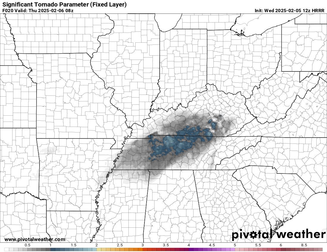
Live emergency update on the WEIRD TORNADO SETUP 2-7 am in Kentucky and extreme northern Tennessee! Stay tuned to watched and warnings during a time you are usually asleep! Even a significant tornado is possible
Tornado threat has UPTRENDED tonight in Kentucky and Tennessee!
5% tornado risk is now in place along the Tennessee and Kentucky border. The threat will be highest between 12-7am. Have multiple ways to receive alerts!
A low-end tornado threat will develop overnight tonight across parts of the Lower Mississippi Valley and Tennessee Valley, as a storm system moves through the region. While the overall severe weather risk is limited, a couple of isolated tornadoes cannot be ruled out, especially in areas from eastern Arkansas into western Tennessee and Kentucky.
The primary concern will be gusty winds and a couple of brief, spin-up tornadoes, mainly during the late evening and overnight hours. Given the overnight nature of this threat, make sure you have multiple ways to receive warnings!