@mnolangray It’s my understanding that anchor tenants in shopping malls often paid very little rent in terms of $ per square foot compared to smaller tenants because mall owners were so eager to attract anchor tenants.
@Johnerandom_@WallStreetApes The address is about 1301 E 21st St MPLS 55404. The construction workers are probably working on affordable housing apartments built by the Native American community. The area has been hit very hard by the fentanyl crisis and is known for high crime and homelessness.
@the_transit_guy It was nice reading this article! I would add that the level of service restored was limited by needing to negotiate trip times with the track owners, BNSF. For several years service was limited due to withdrawn funding from counties who previously committed to operations funding
@2024dion White Pine was designed by a planning firm from Chicago that used the latest in 1950s housing preferences. It has single family homes but it also had apartment buildings and trailer homes to appeal to different housing needs. There is Street View imagery if you want to explore!
@2024dion The book is named “Hollowed Ground”. Copper mines in the UP used to build towns with the idea that workers with families would be more attached to the community and less likely to move elsewhere. Many workers carpooled but commuting for 90 minutes in the UP in winter is not easy!
@MaplehoodUnited Not anytime soon. MnDOT had engineered plans in 2017 but have quietly removed the plans from their website. Streets MN has articles about it.
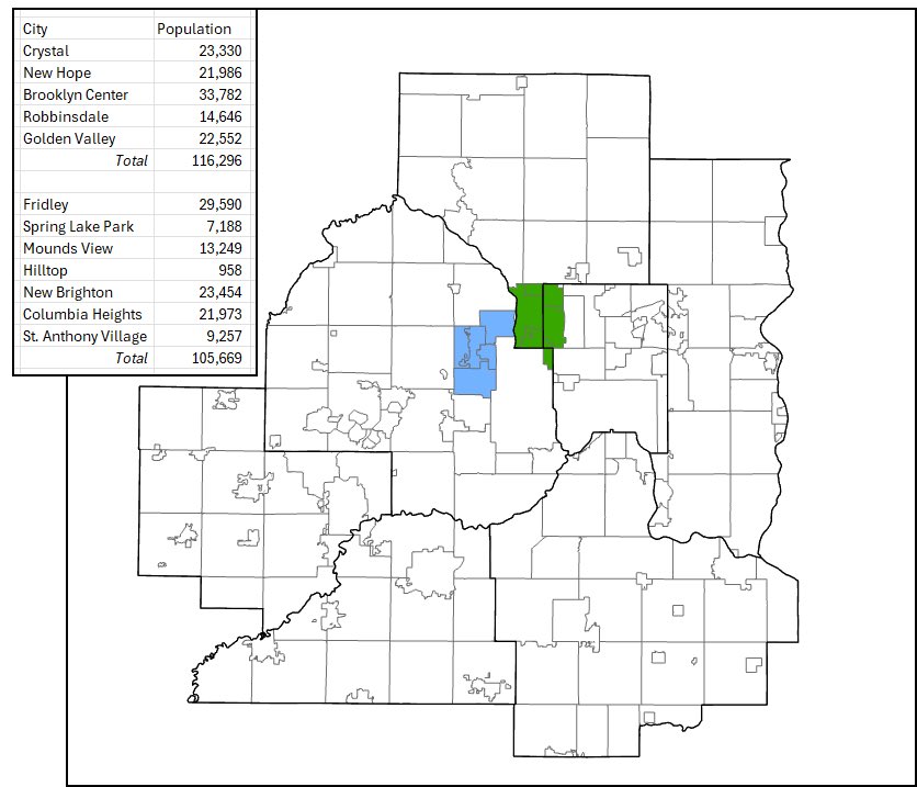
After the Strib published the municipal fragmentation article, a reader wrote in with this proposal. I wanted to see it visually. These would be the 3rd and 4th largest cities in the metro. @MaplehoodUnited
@MaplehoodUnited I used ArcGIS, Snipping Tool, MS Paint, Excel, and population data from Wikipedia. GIS is probably overkill. You could make something similar by using the paintbucket tool to fill in cities with the same color on a blank map.
This one @mtamaryland bus is probably carrying the same amount of people as all of visible cars in this photo. Approximately 75% of vehicle trips in the United States are considered single-occupancy vehicles. Meaning a driver alone in the car. In dense cities, it's all about maximizing the efficiency of physical space. Transit does this well by moving more people in less space.
And it does get congested. Here the two general lanes were so full that cars turning onto the street were struggling to enter Lyndale Ave. There are several other construction projects north and south of here so it will be interesting to see travel patterns after they finish.
Here’s a video of the new bus lanes on Lyndale Ave in action. Right now Routes 4 and 6 use the corridor but in the future the METRO E Line will cruise through this congestion.