To give you a sense of how incredibly rare and unique Hurricane #MELISSA is, here are the most-intense landfalling Atlantic hurricanes that we have on record.
MELISSA is now tied with LABOR DAY 1935 at the top – something I'd never imagine to see in my lifetime.
I will say it again #Melissa's current satellite presentation is to the T with Super Typhoon Haiyan was in 2013. In my 20 years of observing hurricanes in the Atlantic I can't seem to recall anything close to what we're seeing tonight. No comparisons come to mind.
Tracking The #Tropics: A tropical wave in the Atlantic is producing widespread showers and storms. Dry air will limit development over the next couple of days, but gradual strengthening is expected later this week.
We’ve reached the climatological peak of the #Atlantic hurricane season. It’s interesting how quiet things are, since this is usually the busiest time in the tropics
TRACKING THE #TROPICS | A tropical wave over the central tropical Atlantic is producing a small area of disorganized showers and thunderstorms. Conditions are not very favorable, and the chances of this system becoming a tropical depression are going down.
Live from the Jersey Shore: Hurricane #Erin is tracking farther out to sea, and surf conditions are starting to improve. Coastal flooding and dangerous rip currents remain a concern.
This Erin is hoping for a nice beach weekend ☀️
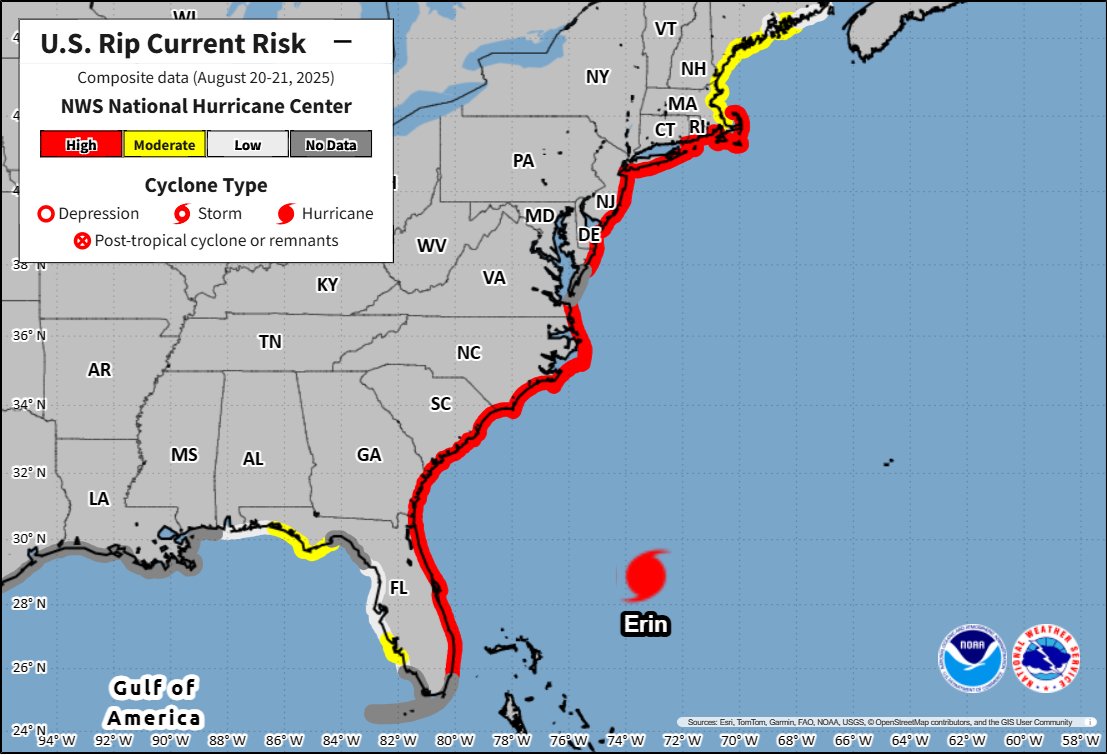
There is a high risk of rip currents from today and on Thursday for most U.S. east coast beaches from South Florida to Massachusetts due to Hurricane #Erin.
Beachgoers are urged to follow information from lifeguards, local authorities, and beach warning flags. The best advice? Stay out of the water!
To help you be safe, you can check on the rip current forecast for the next 2 days here: https://t.co/QalUkrGOQ7
LOOKING AHEAD (8/18) - This is nice to see...long range models are showing a potential cool down in the future. This is the 6-10 outlook for August 23rd-27th. #10weather
#Erin is expected to produce life-threatening surf and rip currents along the beaches of the Bahamas, much of the east coast of the U.S., Bermuda, and Atlantic Canada during the next several days.
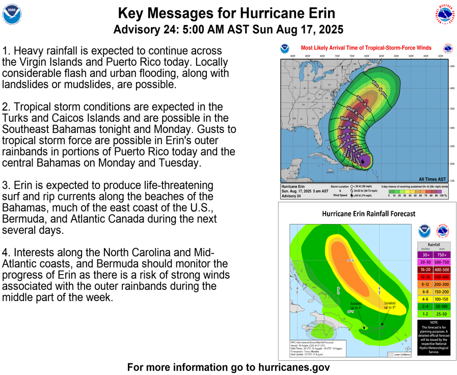
Category 3 Hurricane #Erin is producing gusty winds and heavy rainfall across the Virgin Islands and Puerto Rico.
Tropical Storm Warning has been issued for the Turks and Caicos Islands.
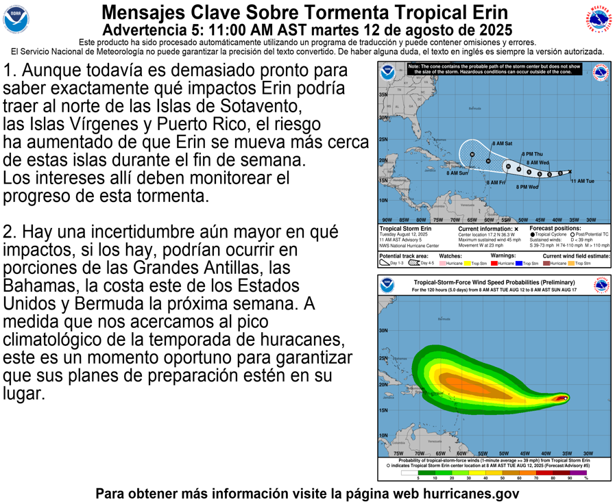
Major Hurricane #Erin passing to the north of Puerto Rico. Tropical Storm Warning has been issued for the Turks and Caicos Islands. Here are the 5 am AST Key Messages. Visit https://t.co/tW4KeGdBFb for updates.
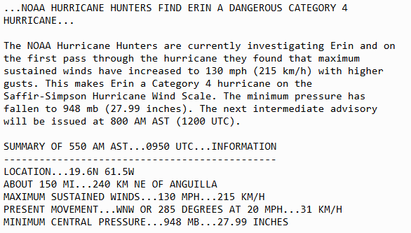
Hurricane #Erin is now a Category 4 storm with maximum sustained winds of 130mph, per the @NOAA_HurrHunter
This Erin will continue to track Hurricane Erin!
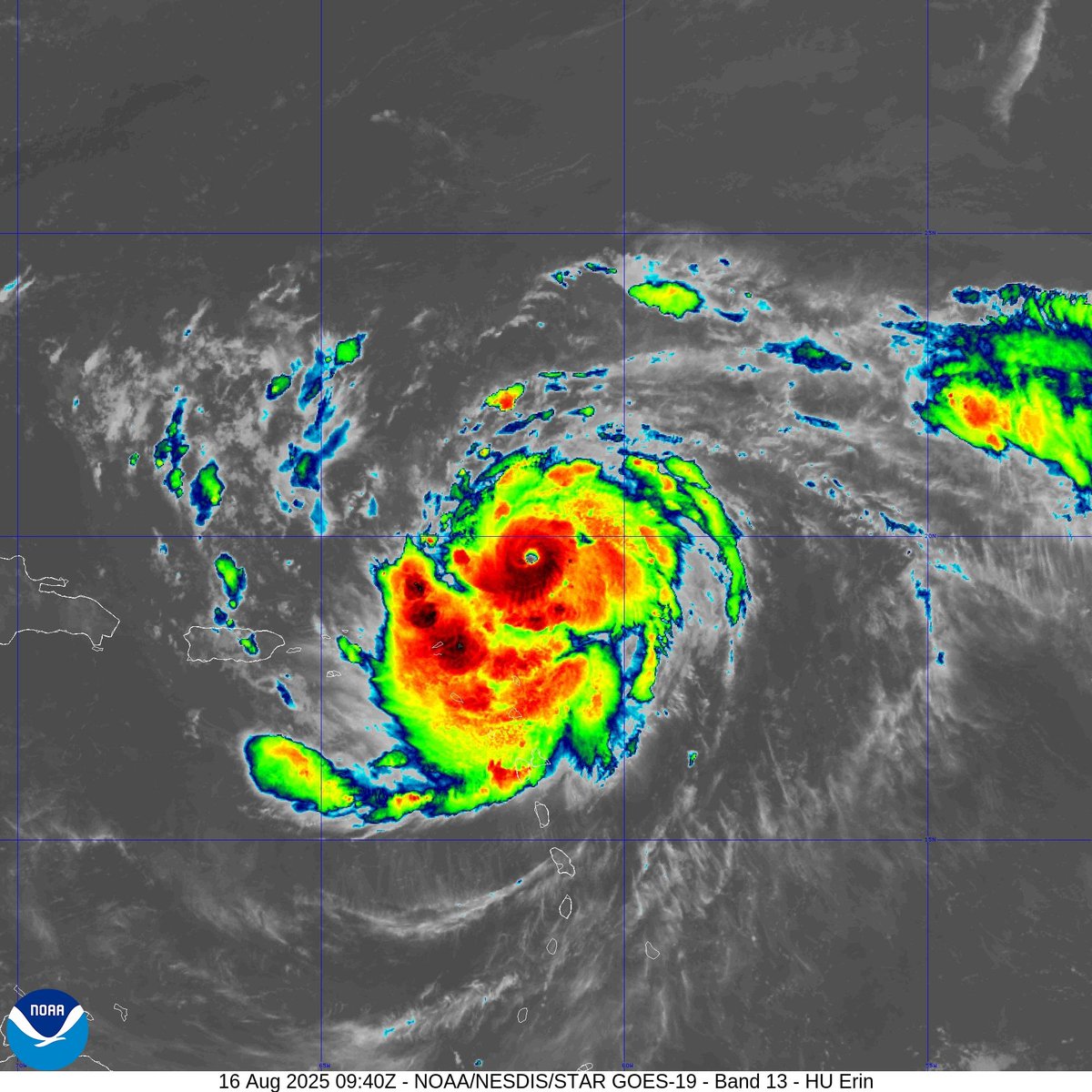
Aug 16 6AM AST: @NOAA_HurrHunter find #Erin has strengthened into a dangerous Category 4 hurricane with maximum sustained winds of 130mph. Stay up to date with the latest forecast at https://t.co/tW4KeGdBFb
Hurricane #Erin Advisory 17: Erin Becomes the First Hurricane of the 2025 Season. Expected to Pass Near Or North of the Leeward Islands On Saturday. https://t.co/tW4KeGdBFb