The FGDC OS's, NSDI Geospatial Data Coordinator position is now open. The announcement on USAJobs is live and applicants can begin submitting applications tomorrow, Oct 3. More details are available at https://t.co/8fqc5olsb4
Exciting opportunity alert! 🌍 FGDC is hiring a National Geospatial Data Asset (NGDA) Coordinator (GS-14) to lead and coordinate geospatial data activities. Open until Dec 4. Check out the details and apply here: https://t.co/lNkzHBLQ6D #Geospatial#JobOpportunity
FGDC's new Executive Director Josh Delmonico will present on the The Future of the US National Spatial Data Infrastructure at the 2023 Esri User Conference today from 2:30 - 4 PM PDT. Come and share your ideas so that we may integrate them into the next NSDI Strategic Plan.
Acting Executive Director of the FGDC, Josh Delmonico, and Deirdre Dalpiaz Bishop from Census talk on a variety of issues including Census counting, data collection, dissemination, and geospatial policy in an interview with @geoworldmedia
https://t.co/mXSvEcwEt2
What’s new in version 3.0 of @fgdcgov’s Work Zone Data Exchange (WZDx) Specification? An additional relationship entity, support for detour information, & increased consistency to lane sequencing for easier adoption and scalability. Learn more at https://t.co/wfxU4Yv5Ap
Interested in learning how access to #WorkZone data can improve driver and worker safety? Or experiences from agencies publishing #WZDx feeds? Register at https://t.co/MezVhxT8kA for a free virtual event on May 19, 1 pm EDT, co-sponsored by @USDOT and @aashtospeaks. #2020gist
On May 19, 1 pm EDT, @USDOT and @aashtospeaks will be hosting a free GIS-T virtual event that unites #GIS and #transportation professionals to discuss improving worker and driver safety through access to #WorkZone data. Register here: https://t.co/MezVhxT8kA #WZDx#2020gist
FGDC member Deirdre Bishop of @uscensusbureau discussing the 'Growing relevance of GIS and location in fetching Census data' in an interview with @geoworldmedia. https://t.co/U5K1Xg4vT5
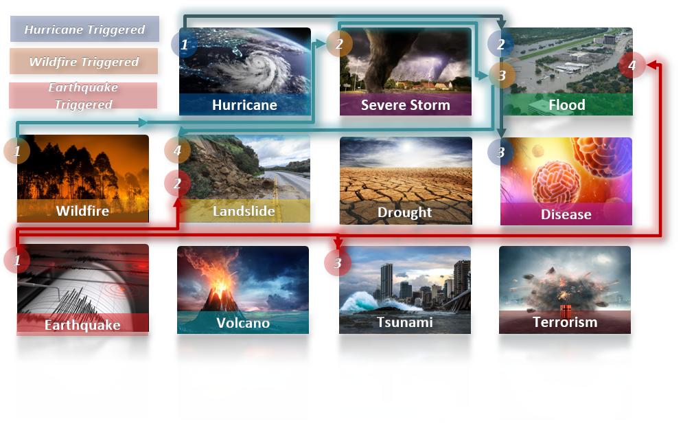
OSTP's Whole-community Hurricane Information Flows Workshop Report is now available at https://t.co/LHbIlkUyMl. The report highlights FGDC's development of the Geospatial Platform to serve as a definitive portal for best-available disaster related data and location-enabled tools.
FGDC is seeking nominations for appointment to the National Geospatial Advisory Committee. Nominations are due August 27, 2018. https://t.co/2mTZ5xrB1g
FGDC's Executive Director Ivan DeLoatch will be giving a lightning talk on the 'FGDC Co-Sponsored Disasters Interoperability Concept Development Study' at #GEOINT2018. Learn more about the talk at https://t.co/elLPW3PTkq
OGC's (free) Disasters CDS Workshop will help advance the concept of a Disaster SDI. Held at @NASA Ames in CA on May 17-18 w/ @USGS@fgdcgov@DHSgov. Anyone that creates or consumes spatial data in aid of disaster preparedness & recovery is urged to attend https://t.co/x1F4NIKzaA
The 2018 State and Future of GEOINT report by @USGIF now available for reading at https://t.co/s6LSwRXL5I. Among other interesting things, it talks about 'GEOINT at Platform Scale'. FGDC's https://t.co/Xym5DH1R7X has been working with #GEOINT in advancing the platform approach!
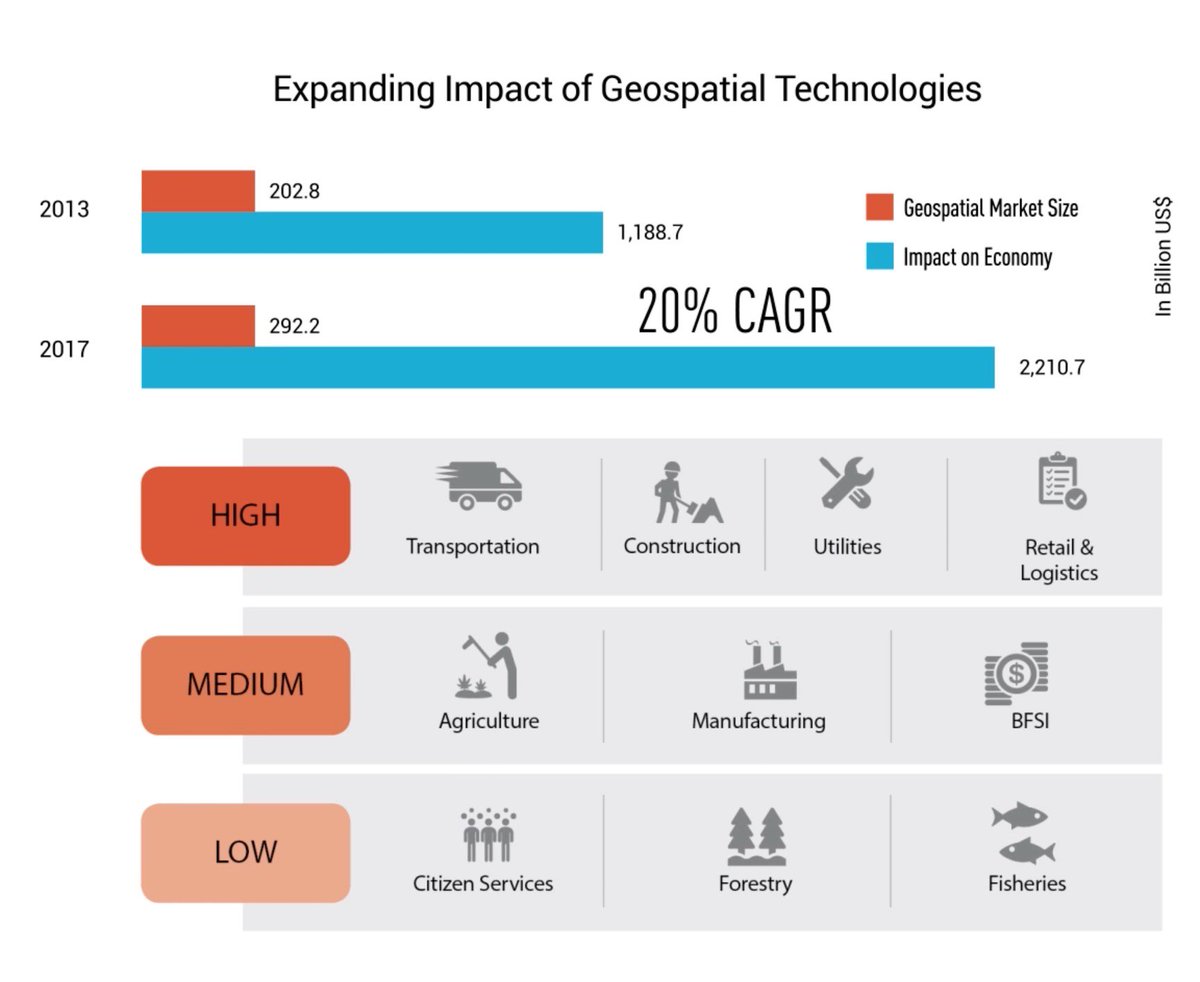
@geobuiz reports the impact of #geospatial technologies has almost doubled from 2013-217 and is growing at 20% CAGR. Read the report at https://t.co/J3vIUcQ0fG
Registration for the 3rd GEO #Data Providers Workshop now closed - we have reached full capacity! Still interested in participating? Join the waiting list or sign up for #GEOSSHack2018. #Sponsorship opportunities are still available as well! https://t.co/IDvNEA6jZV #GDPW3
Join us for #GEOSSHACK2018, where developers will compete to create #OpenData discovery and access tools that contribute to solving some of our most pressing global challenges. https://t.co/imIdOsRJfT #hackathon#datamatters#EO4impact