Where did the sands of the Sahara come from? One man is on a mission to find out, and you can read about it on our blog. #remotesensing#sahara#desert https://t.co/I3DbkCi2ea
Did you get to experience our Smart Digital Reality at Singapore’s Geofest last week? If not, no worries — you can still learn about it here: https://t.co/xrebcMLDrf #SgGeoFest#event#geospatial https://t.co/NYC0zbF9zJ
Yes we are continuing the tradition of kicking off the @opengeospatial with a fireside chat with a woman leader in geospatial - this time Sofie representing our principal member @HexagonAB! @geospatialwomen help me spread the word! https://t.co/QXEopWTY6r
We're thrilled to participate in TeamAware by developing an integrated and cost-efficient situational awareness system for #firstresponders. Learn more now! https://t.co/byb2nGydbj
Four-day virtual event will feature experts speaking on a variety of topics for the government, public safety, utilities, transportation, and defense industries. Read the announcement for more details. https://t.co/pxnAb1ETGD
Hear experts discuss how various forms of digitalization can transform the way you work and achieve success. Find out more. #HxGNLIVE#HxGNResiliency https://t.co/EDesAlFzpK
The Leica RTC360 on Boston Dynamics Spot efficiently combines the high-performance 3D laser scanner, Leica Cyclone FIELD 360 app to pre-register captured scan data in real-time, and Leica Cyclone REGISTER 360 office software to integrate your 3D model... https://t.co/GE8wQnuAyT
Join Hexagon's live Q&A session with female executives where they’ll examine work culture, share advice, and discuss what’s next on the tech front. #HxGNLIVE#HxGNResiliency https://t.co/tvT2UqLeoh
Join Hexagon's own @fhoubie at the virtual #ogcnewspace Workshop! Frédéric will be part of a panel discussion on data preparation, curation, and processing. Interested in attending? Register now: https://t.co/sOJPcmpzwU
If you’re a Power Portfolio customer, please read this important blog post about our plan to support your work-from-home needs and operations during the global pandemic. https://t.co/t2xCMrq2jA
The MARISA GCEP service, developed by @SatwaysLtd, processes data in real time providing an enhanced SA and fast response in critical situations applying a wide range of rules for detecting anomalous behaviour. #MARISAH2020#H2020#Maritime#Security#BehavioralAnalysis
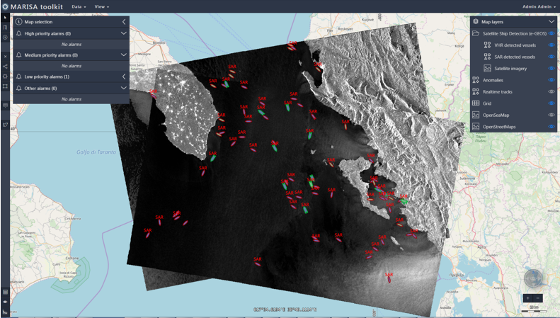
Visualisation of Satellite SAR data from @e_geos into the HMI developed with LuciadRIA. Thanks to #OGC Standards (WMS & WFS), integration was very easy. @LUCIADconnect @HexGeospatial @opengeospatial#maritime
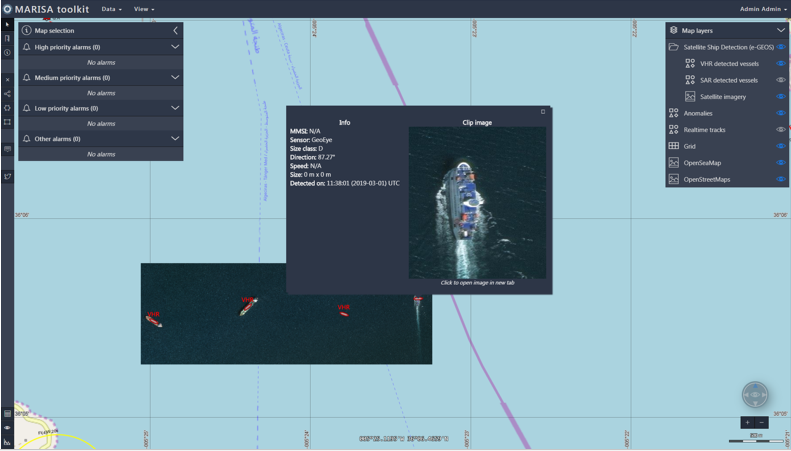
The MARISA Satellite Vessel Detection services, developed by @e_geos, processes SAR and VHR optical satellite data to automatically extract vessels parameters and integrate AIS data, to detect anomalous behaviours #MARISAH2020#Maritime#Safety#Security#Surveillance#Satellite