The Geographic Information Systems Center at Florida International University supports research+teaching in all areas of the spatial sciences and GIS #GIScience
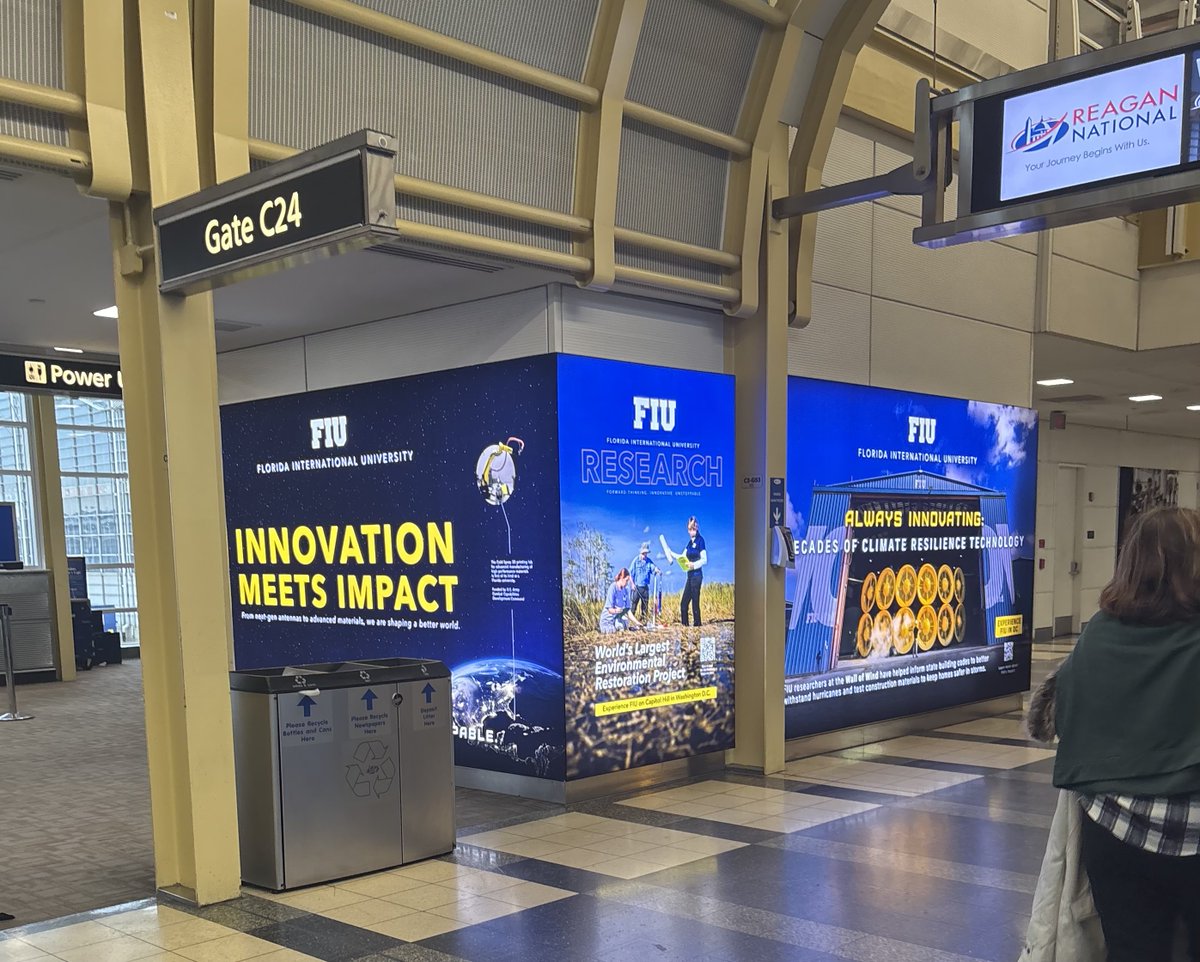
✈️ Traveling from @iflymia 🌴to @Reagan_Airport ❄️ this weekend for the 60th Presidential Inauguration? 🇺🇸 be sure to visit GATE C-24, and snap your selfie 📷 with our @FIUResearch Showcase featuring @FIUEnvironment's work in the #Everglades@EvergladesNPS, @FIUExtremeEvent's leadership on @NSF #ResilientInfrastructure Rsrch, @AFOSR Antennas, @DeptofDefense @ArmyResearchLab Additive Manufacturing. #IMPACTMATTERS #FIUResilience #FIUDefenseTech
Funded PhD Position in Environmental Science, GIScience, and Climate Change @fiugis
🌍🚀 Join us at FIU in Miami! We’re seeking a PhD student for Future Shorelines: a project on GIScience, data science & climate change adaptation.
To read the full job description and apply, ...
🌍🚀 Join us at FIU in Miami! 🌊🌿We’re seeking a #PhD student for FutureShorelines (https://t.co/1SGgKhBpy0): a project at the intersection of GIScience, data science & climate change adaptation. Details👉 https://t.co/93QFQz9M7M #GIS#ClimateChange#DataScience#SeaLevelRise
📜📢Hot off the press.
Correctness Comparison of ChatGPT-4, Gemini, Claude-3, and Copilot for Spatial Tasks
Since an #AI#chatbot powered by an #llm is not sci-fi anymore, we need to understand their #geospatial capabilities more.
https://t.co/fBwNOzIGMZ
@fiugis@ufgeomatics
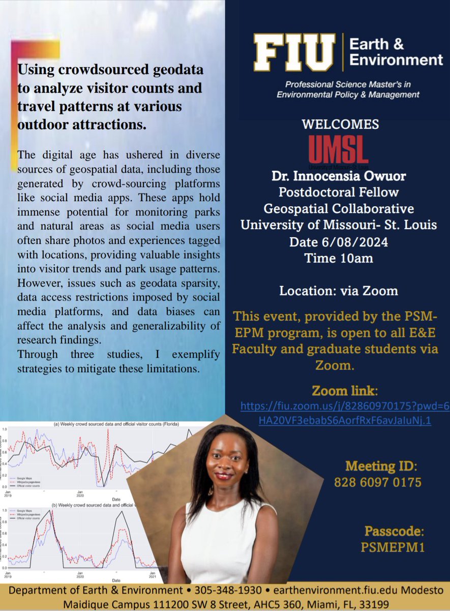
Join us for an online seminar with @OInnocensia, who will be talking about the role of crowdsourced geodata in monitoring visitation patterns at outdoor attractions. The seminar is part of the PSM Environmental Policy & Management program. DM for link. @FIUCASE
Can't figure out where to publish your #GIS or #GIScience paper? This new research may help you decide! It assesses journals across commonly used metrics, and also reviews the publication landscape in our field. Hot off the press in @ijgis. Enjoy! https://t.co/qr7KhXHdJT
📢📝New paper in @ijgis! I review #GIScience publication trends and journals to help keep stock of our field. I hope that it will be a useful resource for both early career and established researchers.
Read below to see some of the key points ⬇️ 🧵
https://t.co/jgGSodyHia @fiugis
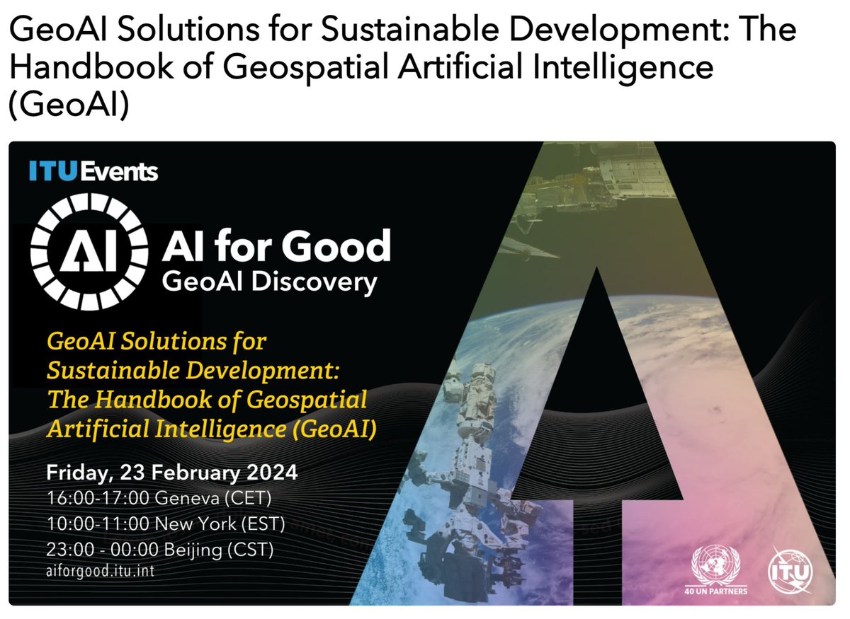
The International Telecommunication Union @ITU is organizing the webinar series on AI for Good. You are cordially invited to join the forthcoming one is about #GeoAI Discovery on February 23. Registration: https://t.co/7FVrgfSYno
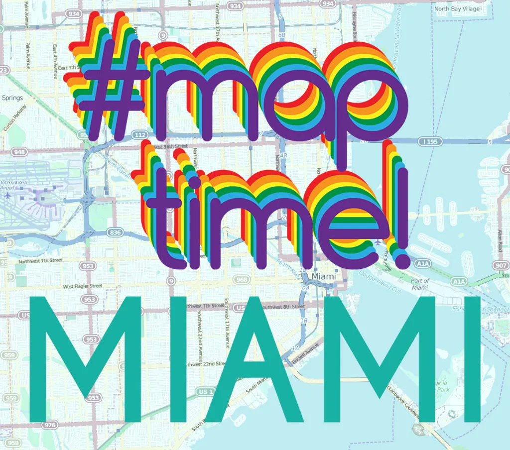
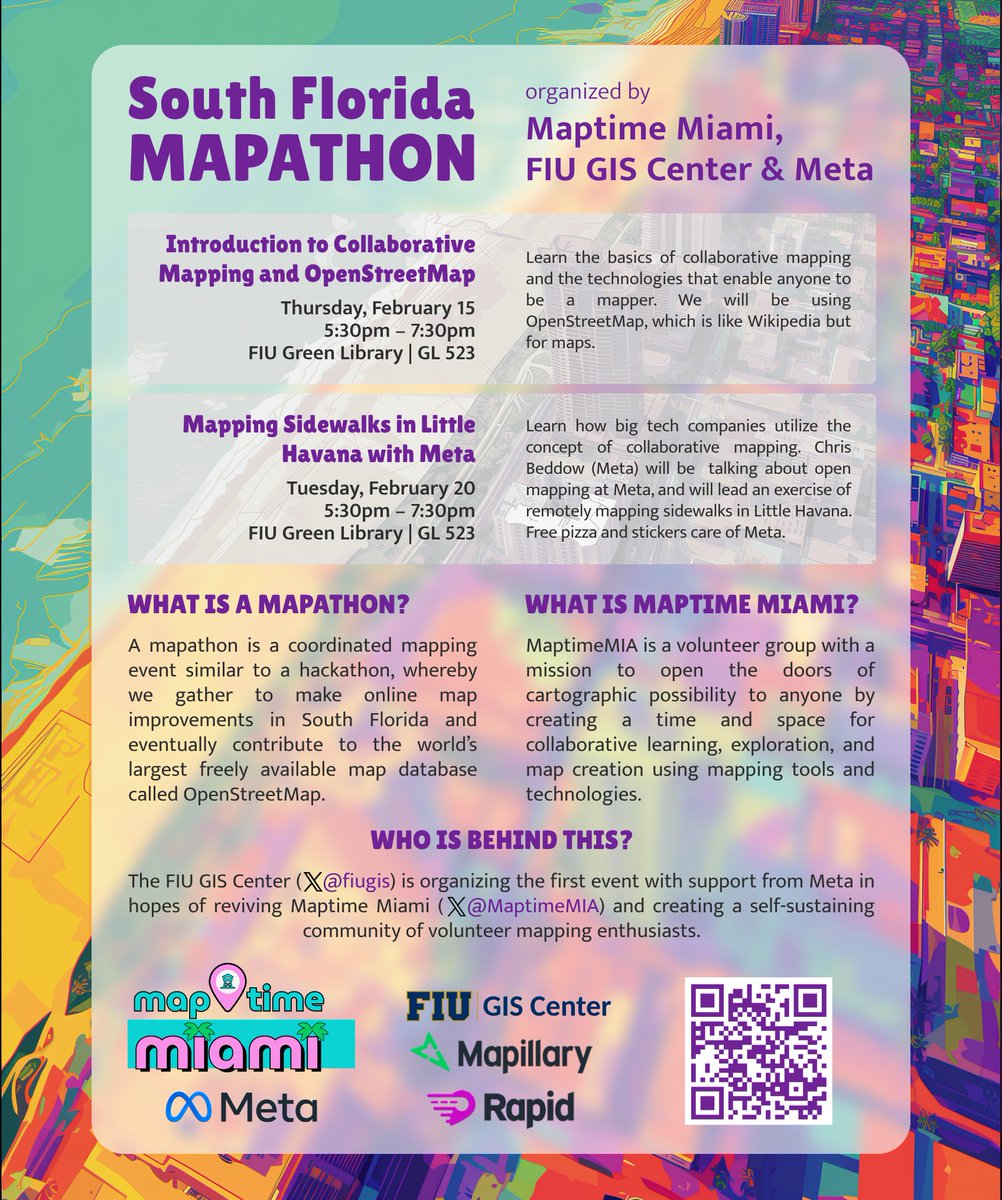
Save the date(s)! Learn about open mapping through this 2-part Mapathon organized in collaboration with @Meta. These events are part of our effort revive @MaptimeMIA and therefore it is open to anyone regardless of affiliation, background, skills.
Psst, did you hear about the upcoming Mapathon in Miami? We're working to revive @MaptimeMIA with a mapping workshop co-organized with @Meta. When: mid-late February. Where: @fiugis. Stay tuned for details and Happy Mapping! @MaptimeHQ@cbed32@FIU
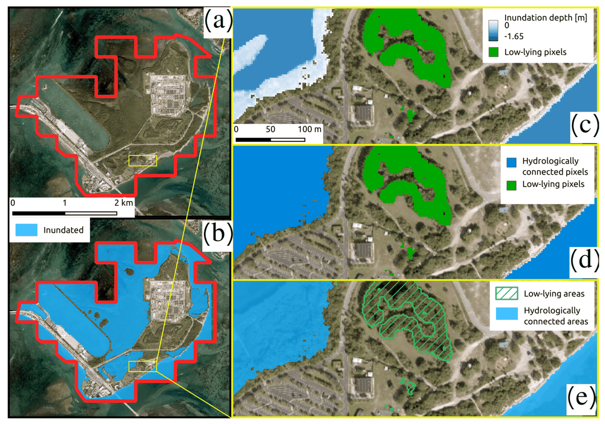
Our paper "Beyond the Tide: A Comprehensive Guide to #SeaLevelRise Inundation Mapping Using #FOSS4G" is the current cover of @Geomatics_MDPI! We present an alternative approach to propitiatory tools and software to map SLR. @fiugis@FIUEnvironment
https://t.co/T8PJ7DNgOR
Discover the role of GIS in public health!
Join us on January 26th at Wertheim Conservatory 130.
This course provides a perfect opportunity for public health professionals and researchers to learn how to utilize GIS effectively in their field.
We can't wait to see you there!
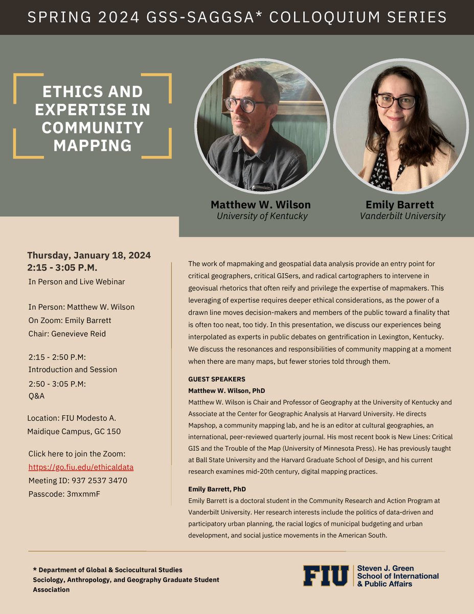
Join us for an upcoming colloquium on Jan 18th featuring guest speakers Dr. Matthew W. Wilson from the University of Kentucky and Dr. Emily Barrett from Vanderbilt University, hosted by FIU Department of Global & Sociocultural Studies. Looking forward to everyone's participation!
New article published in #Geomatics describes sea level rise inundation mapping in detail and provides and open-source alternative to proprietary software. "Beyond the Tide: A Comprehensive Guide to Sea-Level-Rise Inundation Mapping Using FOSS4G"
https://t.co/GaMK6zGTmF
New article published in #Geomatics describes sea level rise inundation mapping in detail and provides and open-source alternative to proprietary software. "Beyond the Tide: A Comprehensive Guide to Sea-Level-Rise Inundation Mapping Using FOSS4G"
https://t.co/GaMK6zGTmF https://t.co/FodfWs0Jk1
Friendly reminder that spatial data still goes to die on Null Island. We wrote a fun but serious article about it that explains why this is important.
Article: https://t.co/KyJljETm2b Clip: https://t.co/WhCMKpVF7d
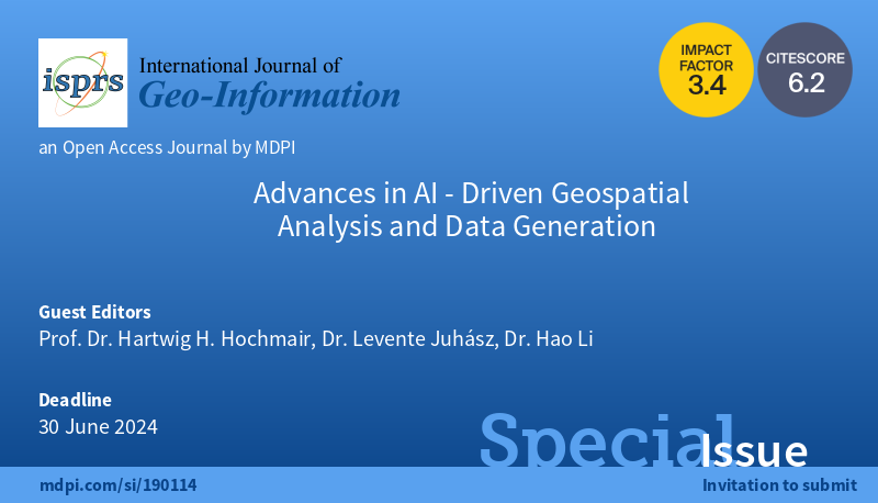
📢The #SpecialIssue "Advances in AI-Driven #Geospatial Analysis and Data Generation" is online and we welcome you to submit your research!
Edited by Prof. Dr. Hartwig H. Hochmair, @juhaszlevi and @bobleegogogo
🗓️Submissions deadline: 30 June 2024
👉https://t.co/xnMXHwN8A3
New special issue in @ISPRS_IJGI co-edited by our GIScience director @juhaszlevi aims to collect research centered around the use of #AI for mapping, extraction, generation, analysis, and communication of spatial data. Deadline: June 30, 2024. Read more at https://t.co/532OmX4s0l
📢 I am co-editing a new special issue titled "Advances in AI-Driven Geospatial Analysis and Data Generation" in @ISPRS_IJGI with @ufgeomatics and @bobleegogogo. Questions? Reach out! Submission deadline: June 30, 2024. https://t.co/FeytiResTh @fiugis @FIULibraries
New #preprint with our friends at @FIUEnvironment provides a comprehensive guide to coastal inundation mapping using only free & open-spurce geospatial tools. This can help break down barriers and make the process more accessible, even in resource-constrained environments.
Pls RT: Did we already mention excellent opportunity for personal and academic growth, supportive new colleagues @uzh_geo @UZH_dsi @UZH_Science, most livable urban environment, and…🔔Apply Now 🕛 👉🏼 https://t.co/FoF2JXiG9M ‼️😊