I am very excited to release GeoLibre v1.0 🌍
GeoLibre is a free and open-source, lightweight, cloud-native GIS platform for visualizing, exploring, and analyzing geospatial data. One application that runs everywhere: in your web browser, as a native desktop app, on your phone, and inside a Jupyter notebook. No account, no server, no cost. Everything runs locally and your data stays private.
In this video, I walk through GeoLibre 1.0 step by step: how to install and run it, load vector and raster data, stream gigabyte-scale cloud-native datasets without downloading them, edit attributes and geometry, work with PMTiles, 3D tiles, LiDAR point clouds, and DuckDB, and share your projects as static links.
GeoLibre is built on MapLibre GL JS, React + TypeScript, Tauri (Rust), DuckDB, and https://t.co/Iu3zs18MyS.
Try it: https://t.co/7VA2AQpaJK
GitHub: https://t.co/VXq8c1oACL
Full video tutorial: https://t.co/nmlHL8I80Y
If you have feature requests or run into bugs, leave a comment or open an issue on GitHub. And if you find GeoLibre useful, please give it a star.
#GIS #OpenSource #Geospatial #MapLibre #Python #DataVisualization #GeoLibre
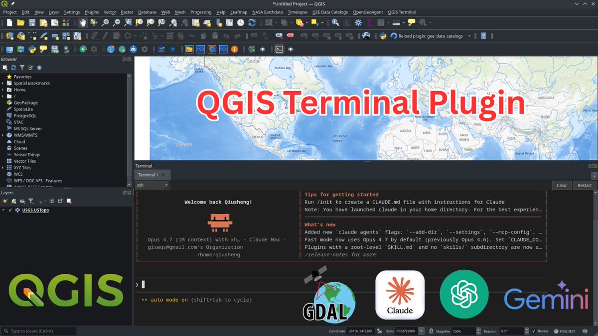
Introducing QGIS Terminal Plugin: An Integrated Terminal for QGIS
Discover the new QGIS Terminal Plugin that lets you run terminal commands directly inside QGIS , no more switching between your GIS desktop and external terminals. In this tutorial, you'll learn how to install the plugin, customize the integrated terminal, manage multiple tabs, and run tools like Claude Code, Codex, Conda environments, and standard Linux commands right inside QGIS.
GitHub: https://t.co/UVImjsM4BO
Video tutorial: https://t.co/DELpzzHbSq
#QGIS #geospatial #opensource
Geospatial traffic data is incredibly tough to find.
To make things easier for you, I've compiled a comprehensive list of traffic and mobility datasets:
GeoDeep is a Python package that can detect objects in satellite imagery. It's made up of 1,026 lines of Python and uses ONNX Runtime and Rasterio extensively
De acuerdo a esta infografía, desde 1851 hemos tenido en 🇻🇪 sólo 3 huracanes que han tocado tierra: dos en Falcón y uno en la península de Paria, siendo este último el más reciente (1933).
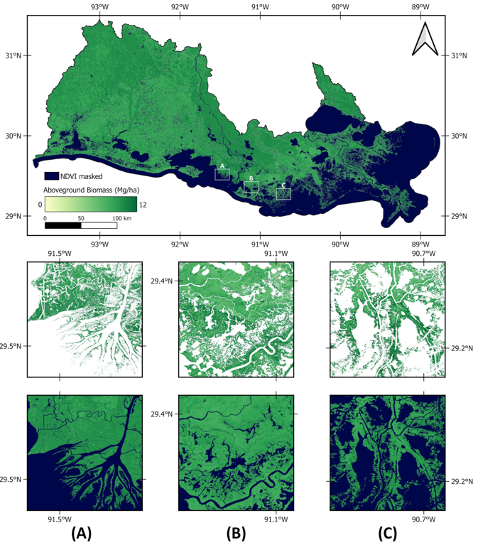
🌿🌳 Integrating #SAR and #Optical Data for Aboveground #Biomass Estimation of Coastal #Wetlands Using #MachineLearning: Multi-Scale Approach
✍️ Mohammadali Hemati et al.
🔗 https://t.co/eHYcd4O8Ph
Change Detection Method for Remote Sensing Images Based on Google Earth Engine
Tutorial Link: https://t.co/r01EAjRS3K
Registration open:
For more details visit our website:
https://t.co/i4EFoxX5HU
#gee#googleearthengine#gis#geospatial
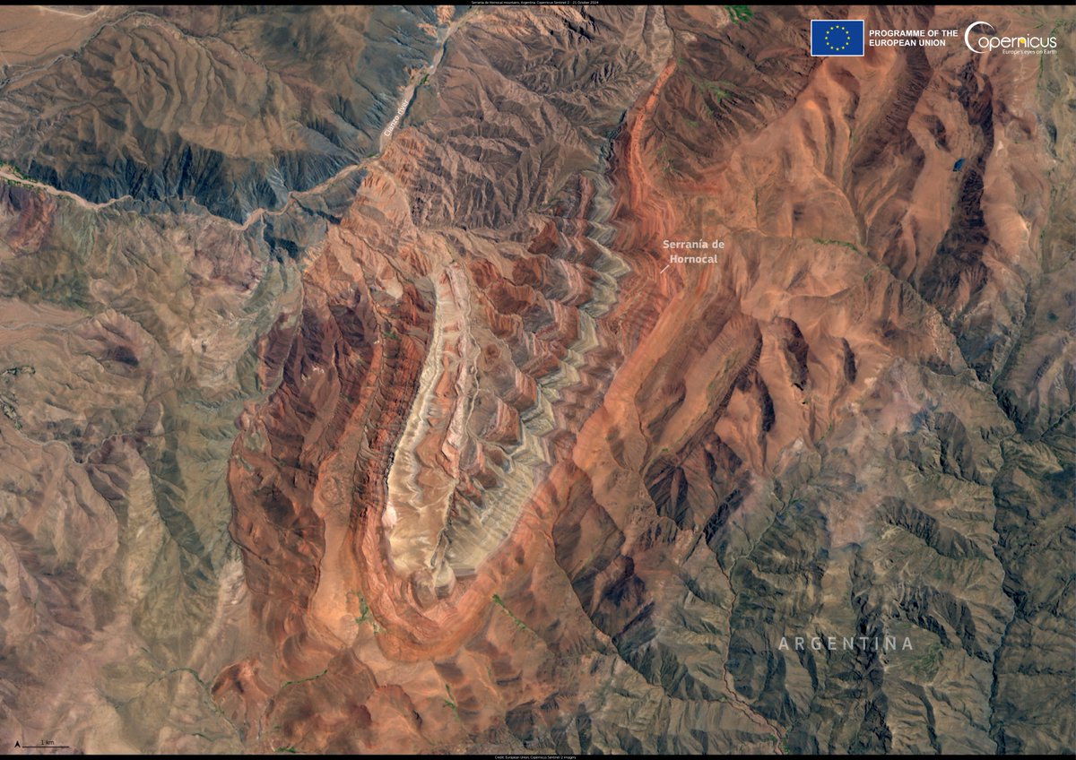
This #Sentinel2 image from 21 October 2024 shows the beautiful hues of Serranía de Hornocal mountain range.
Known as the ‘Mountain of 14 Colours’, it is one of the most stunning landscapes in the Andes.
Located in northern 🇦🇷, it is famous for its vibrant, multicolored slopes.
¿Conoces los principales índices de #vegetación en #teledetección? Desde el clásico #NDVI hasta el #EVI y #SAVI. Aprende a utilizarlos para mejorar tus análisis de ecosistemas. 🚀
🔗 https://t.co/CgWEoa0j34
👉 ¿Usas algún índice en particular? ¡Comparte en comentarios! 💬
Series temporales de #NDVI en cultivos de caña de azúcar en la provincia de Tucumán 🇦🇷
Poderosa herramienta de análisis que brinda más contexto cuando de clasificación de cultivos se trata. #RemoteSensing
Buscamos profesionales interesados en formar parte de la Comisión de Inteligencia Artificial del CIT 🙌
Si desea formar parte, envíe su CV al correo [email protected]
🗺️En el Grupo 11. #Patrimonio de los Datos Espaciales de Referencia de Andalucía se han actualizado las capas correspondientes a los #Espacios#naturales#protegidos
✅Figura de gestión
✅Figura de protección
✅Régimen de protección
https://t.co/P87XvDHGz0
#FEDER#DERA
🆕Nueva actualización de los Datos Espaciales de Referencia de Andalucía #DERA, repertorio de bases cartográficas en bloques temáticos: 🏔️#relieve, 🌊#hidrografía, #transportes y comunicaciones, divisiones administrativas…
https://t.co/P87XvDHGz0 #FEDER
🎓Posgrado en Catastro 100% On-line
👨🏫👩🏫70% docentes del Catastro
📚Programa modular
Dentro de esas titulaciones está el de 𝗘𝘀𝗽𝗲𝗰𝗶𝗮��𝗶𝘀𝘁𝗮 𝗲𝗻 𝗖𝗮𝘁𝗮𝘀𝘁𝗿𝗼, 𝗣𝗿𝗼𝗰𝗲𝗱𝗶𝗺𝗶𝗲𝗻𝘁𝗼𝘀 𝗖𝗮𝘁𝗮𝘀𝘁𝗿𝗮𝗹𝗲𝘀 𝘆 𝗖𝗮𝗿𝘁𝗼𝗴𝗿𝗮𝗳í𝗮
Sigue el hilo.. 🧵👇