“Penetration pricing” is the term used when a company burns through Venture Capital money selling a product under its cost to build market share.
Remember how cheap Uber and Lyft used to be? VCs subsidized the drivers and the riders for years. Then they went public and now it costs me $20 for a 3 minute ride down the road.
DoorDash, Uber Eats, Instacart.
MoviePass, Netflix, Hulu.
All of these companies sold below cost to get market share then massively raised their prices, added ads, diminished their products, etc.
AI today is no different. OpenAI and Anthropic are giving us all cheap rides. To do that, they’re selling $1.00 for 10 cents.
Get it while you can before a different kind of penetration begins.
🔥 Hot take: Geospatial Foundation Models (GFMs) are brittle.
So, we built EarthShift 🌍 — the first public testbed for benchmarking the robustness of GFMs across realistic distribution shifts in remote sensing!
📄 Paper: https://t.co/4z6qWPwgi1
(Thread)
CEOs are quietly realizing the AI replacement plan has a problem.
Two problems, actually.
One: the token costs for running AI agents are now exceeding what they were paying the employees they fired.
Two: when the tokens run out, the AI stops. Just stops. No continuity. No workaround. Just a spinning wheel where your workforce used to be.
You fired humans to save money and bought a subscription that bills you into a corner.
The employees you let go knew what to do when things broke.
The AI just invoices you for the outage.
And then there’s the permission problem nobody wants to talk about.
To do its job, the AI agent needs access. Full access. Your systems, your patents, your contracts, your future plans. Everything you spent years building, handed over to a process that has no loyalty, no discretion, and no skin in the game.
You didn’t hire a replacement.
You gave a stranger with no soul the keys to everything you own.
Enjoy.
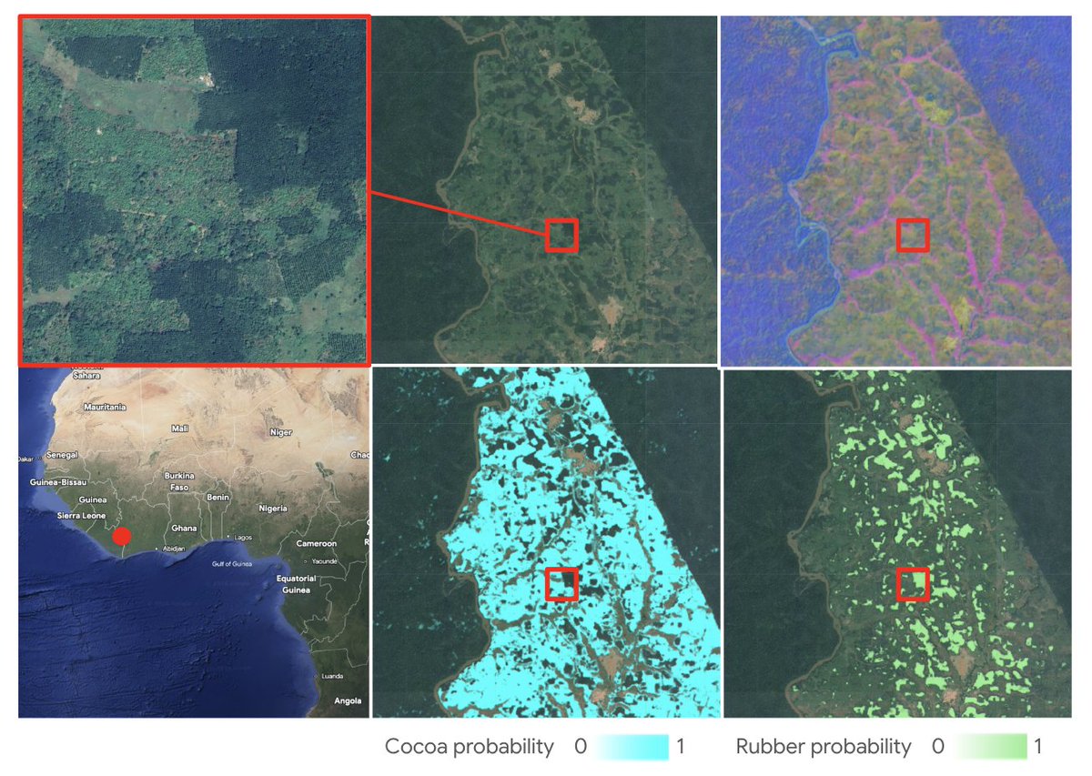
Today, we're excited to announce a major milestone in spatial transparency: the launch of annual, global commodity tree crop maps (coffee, cocoa, oil palm and rubber) built with Google’s Satellite Embedding dataset, part of Google Earth AI. https://t.co/CO5Hjvn9yK
This dataset represents the first pan-tropical, open source, 10-meter resolution map for cocoa, coffee, and rubber, key commodity tree crops associated with deforestation.
These maps are a core output of the Forest Data Partnership (FDaP), a global consortium dedicated to halting forest loss by collaboratively improving monitoring and supply chain tracking. By scaling our coverage from individual countries to the entire tropical belt, we’re closing a critical data gap that has hindered conservation efforts for decades.
Excited to share FOTBCD a new building change detection dataset (0.2m, 512x512).
• Binary: ~28k pairs (change,no-change) — on 🤗 HF
https://t.co/LibRuxJPWA
• Instances: 4k pairs with building polygons labeled
UNCHANGED / DEMOLISHED / NEW
Code & more:
https://t.co/USN2ChjQI1
What happens when you can monitor global cropland daily in near real time?
On the latest #AgTechTalk podcast by @AgBusinessMedia, Andrew Pylypchuk breaks down how next-gen satellite data is reshaping #agriculture and the ag value chain.
🎧Listen now: https://t.co/O2IZjwyLLA
Can AlphaEarth Foundations embeddings preserve interpretable structure after aggregation from pixels to field polygons? We used RasterFlow to build the mosaic and vectorized predictions, then an experimental zonal-stats step computed field-level means. https://t.co/0eNl5mwBpj
LabelMe v6.2 is out.
- Oriented rectangle shape: a rotated bounding box that hugs off-angle objects (parking lots from above, ships, scanned text).
- More AI-assisted shapes: oriented rectangle, rectangle, and circle, fitted from a SAM mask.
Cars in a parking lot don’t line up with the X axis. Their bounding boxes shouldn’t either.
Oriented rectangles, landing in the next @LabelMeAI release.
With seven satellites now in orbit, @EarthDailyA is moving into the next phase of constellation deployment and commercial readiness.
Our new blog looks at what comes next.
👉Read more: https://t.co/auFZLLHARA
#EarthObservation#SatelliteLaunch#SpaceTech