When someone asks me how mature an Earth observation (EO) solution is, I often have two very different answers: "Technically advanced? Very much. Successfully adopted by users? Hard to say"
That’s mainly because our go-to measure of maturity in EO has been NASA’s Technology Readiness Level (TRL), a scale that was originally developed to judge whether a technology was ready for space missions.
But, technical readiness is not adoption readiness.
Currently we don't have one globally accepted scale to measure the adoption of an EO solution that can be used by all parties:
EO and EO-related companies to show where their solutions stand, EO users to judge what they are buying, government agencies to decide what to fund, and investors to evaluate an EO company’s traction.
The scale should also be built for the age of AI when creating a geospatial solution has become so much faster and easier that every EO solution now has to beat what customers could build with AI themselves.
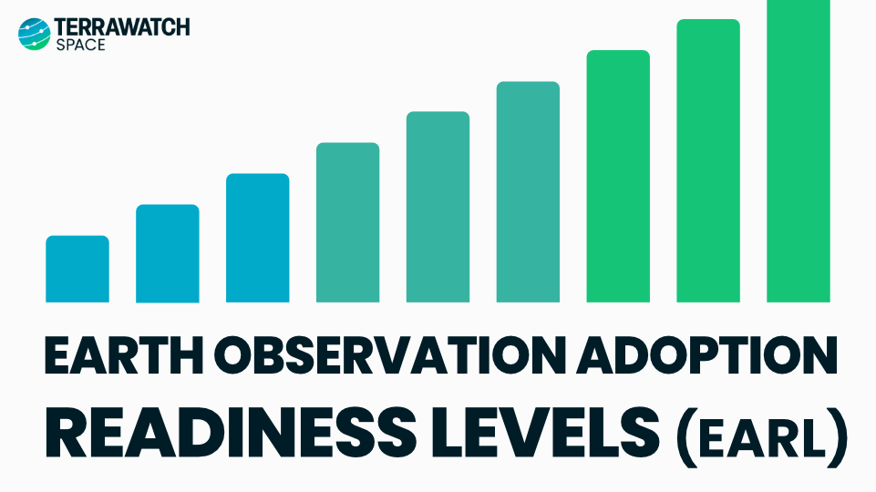
So with all that in mind, I created the EO Adoption Readiness Level, or EARL, a nine-level scale to test an EO solution from the problem it could solve to the point where using EO becomes the norm to solve that problem.
In the latest deep-dive I explain what the 9 levels of EARL are (with examples), how they work, how EARL accounts for AI, takeaways from applying EARL to real EO solutions and companies + how each party above can use it.
Free preview for all, full piece for Premium subscribers of @terrawatchspace
Imagine investing millions of $$$ in a new Earth observation satellite constellation, but only to discover that existing satellite data combined with AI could deliver what the customers actually need
Or the opposite: investing millions in better AI models when the application requires data that existing satellites simply do not provide.
Both the scenarios above are entirely plausible (and is already quite real).
As AI continues to advance, I am becoming more and more fascinated about the question of what EO satellites we need to build and why. Could AI make some EO satellites commercially unnecessary, while making others more valuable?
I explore three different approaches to developing EO future capabilities, and their commercial implications, in this week's Pro edition of the @terrawatchspace newsletter.
NOAA’s revised GeoXO weather satellite program is a good example of the public-private roles in Earth observation that I have written about before.
Three instruments were cut from the program: the Lightning Mapper, Ocean Color sensor and Atmospheric Composition sensor.
It is true that the private weather satellite sector is growing - NOAA is already buying commercial weather data from microwave sounding, radio occultation, reflectometry and imagery from companies such as Tomorrow io, Spire, PlanetiQ, Muon Space, Weather Stream etc. through its new 10-year $2.35B initiative.
The catch? There are no equivalent replacements today available in private sector for continuous geostationary lightning mapping, hourly atmospheric composition monitoring or high-frequency ocean colour observations -- and there may never be!
Yes, theoretically, some startups could work on those problems and make the data available for NOAA to purchase. But honestly I cannot think of a business case for building a dedicated satellite constellation for hourly measurement of air quality pollutants or highly radiometrically-calibrated ocean monitoring.
Some stopgaps exist, but they are insufficient for the 2030s - TEMPO and PACE are research missions Sentinel-4 covers Europe and there is nothing lined up to replace the GOES lightning mapper when it retires in the 2030s (like Europe's Meteosat-12).
So, the impact is there will be genuine data gaps affecting extreme weather warnings, wildfire smoke & air quality monitoring (which is becoming common), and coastal/ocean hazards.
Takeaway: The private sector can fill any EO data gap but only if the government commits to being a long-term customer, the way defence does - if not, it remains a public sector responsibility. Cutting instruments simply means losing capabilities that the commercial market rationally has no incentive to replace
As awareness and adoption of Earth observation increases, it is starting to be increasingly used for more than just monitoring - it is actually now being used in actual decision making across enterprise and government levels, with real financial, regulatory and operational consequences.
As the industry starts using "decision-ready intelligence", we need to look more closely at what this actually means, particularly when the information is incomplete, uncertain or disputed.
But, who decides how much uncertainty is acceptable, and who bears the consequences when that judgement is wrong?
The most important thing we may need to figure out is the difference between when EO evidence is sufficient to trigger an action automatically and when it may not be sufficient on its own to justify a final decision.
In the latest edition of the @terrawatchspace Pro newsletter, I dig deeper into what decision-ready intelligence means, how AI is actually making things harder (not easier) and what it means for companies offering offering EO-based products.
I have been in Earth observation for the past decade and for most of that time the traditional model for EO has always been "technology-led": build and demonstrate a new sensor/satellite, try to identify applications and users.
Then once in orbit, push the technology into the market and wait for adoption, before starting the cycle again with the next generation of sensors.
No wonder EO adoption was slow because the process began with what satellites can do and not what (and in which form) the users needed the information.
However, since the last few years we are slowly moving towards a "problem-driven" EO strategy, which reorders that logic slightly: start with the problem, verify if it is actually a problem worth solving, whether EO is really needed and whether we need more satellites.
Only after these questions are answered does the original 4 questions come in.
TL;DR: I think the overall goal is to move from pushing data outwards and hoping it finds traction to pulling technology inwards and aligning it with defined needs.
“Sovereignty” is probably the most overused term in the Earth observation sector today. According to TerraWatch analysis, we track at least 76 governments that have either announced or have ongoing activities related to deploying their sovereign EO solutions.
But how sovereign is sovereign?
Some countries are buying dedicated satellites from companies that deliver them in less than a year, some countries are reserving exclusive capacity on commercial EO satellites and others are commissioning fully nationally built and owned constellations. But all of these are called "sovereign."
A better way to think about sovereignty is perhaps as a stack of control points across the EO value chain. So, I recently came up with 10 layers of sovereignty that go all the way from one end to the other.
1. Industrial sovereignty
2. Deployment sovereignty
3. Asset sovereignty
4. Operations sovereignty
5. Collection sovereignty
6. Access sovereignty
7. Data sovereignty
8. Processing sovereignty
9. AI model sovereignty
10. Application sovereignty
In the latest edition of the @terrawatchspace Pro newsletter, I detailed the 10 layers of EO sovereignty, analysed whether any EO system can be fully sovereign, discussed the differences between sovereignty and autarky and what the future of EO sovereignty would look like.
In addition news and insights on Earth observation and applications, the latest edition of the TerraWatch Pro newsletter includes an in-depth analysis of the latest EO budget request from Japan.
Japan's FY2027 budget proposal is a good representation of how the three segments of EO development are evolving at the same time:
i) government is continuing to build strategic observing infrastructure,
ii) becoming a much larger customer for commercial EO data, and
iii) embedding satellite-derived information into downstream public services.
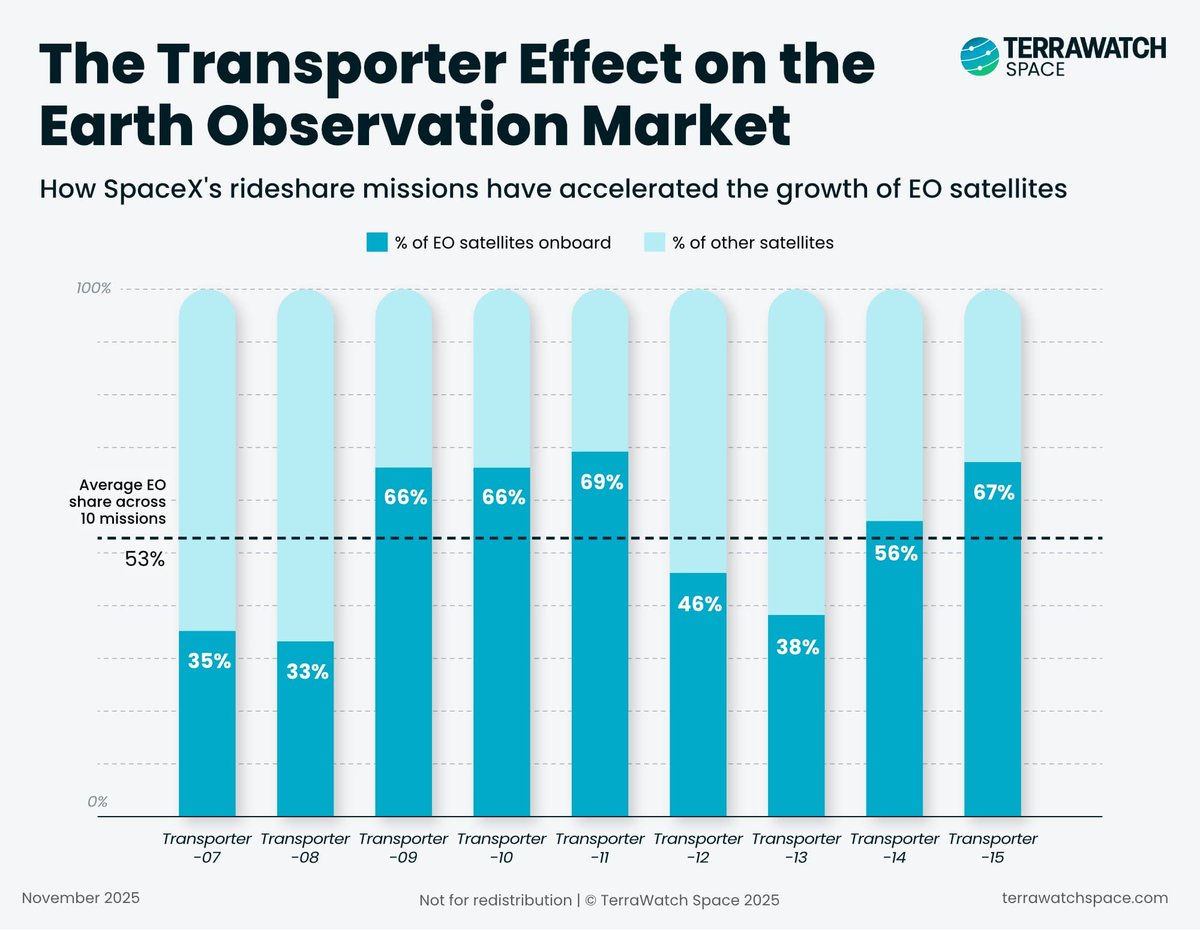
Just had a look at the manifest for Transporter-18 and as has always been the case, Earth observation satellites lead the pack.
Out of the 130 satellites launching later today, at least 65 (~50%) are EO satellites across optical, SAR, RF, AIS, hyperspectral, sounder, thermal...
According to @terrawatchspace analysis, on average about 53 % of all payloads launched on SpaceX Transporter rideshare missions are EO satellites.
So, if you were wondering which segment of the space industry is going to be affected the most with the Falcon 9 phasing out 👇
Sovereignty is perhaps of the one of the more paradoxical ideas in Earth observation today:
One, because it is an industry that basically runs on an open-source software stack - most EO products or EO-derived solutions uses/runs on Python, R, GDAL, Xarray, PyTorch, Zarr, GeoPandas, Leaflet, QGIS, Pangeo, STAC etc.
These libraries and tools are built and maintained by a truly global community - one can 'sovereignize' where the infrastructure runs, but not the community that is building and continuously improving the technology underneath it.
Two, because a truly global EO solution requires global cooperation and collaboration among public, private and research community to advance across the value chain - from standards for data acquisition, management and processing to calibration/validation and training data collected across geographies and shared through common global frameworks.
I know that we are going through an unprecedented time geopolitically and it requires every government, company and organisation to look inward. But the mistake, from an EO perspective, is to confuse sovereignty (control) with autarky (self-sufficiency).
EO is global by nature, and some of the infrastructure that makes sovereign EO capabilities possible is itself built through planetary-scale systems and communities that are transcend national boundaries.
Google’s WeatherNext 3 is currently the best-performing global AI weather model, according to independent evaluation from Brightband. But why is Google investing so heavily in weather?
I think there are two reasons:
1. Making existing Google products more valuable
The first reason is quite straightforward - more accurate global weather forecasts make Google’s existing products more valuable and differentiated: improve the Search and Gemini experience, make Maps more useful and improve services that companies already pay Google to use in their own applications.
So, unlike traditional weather companies that monetise weather by developing separate products, Google is unlikely to make money from the forecast itself. Weather can simply make the products and services it already owns more useful.
2. Platformization of weather
The second reason is more interesting for me: making weather part of the cloud infrastructure itself (which I call platformization).
WeatherNext forecasts are already available through BigQuery, Earth Engine and Cloud Storage, which means developers and enterprises can increasingly treat weather like another programmable dataset rather than a separate product.
If forecasts are available on demand, customisable and embedded into the same infrastructure companies already use, users can start building around them: alerts, simulations, pricing, optimisation and planning (think energy, insurance, agriculture, logistics etc.).
So, Google is not necessarily trying to become a weather company. It is trying to make weather not just a product user buys but a sticky service layer they build on top of, integrate with and ultimately depend on for their business.
---
TL;DR: Google's strategy is to make weather intelligence valuable by improving its own products while also making weather as an infrastructure that others can build on.
The latest edition of the @terrawatchspace Pro newsletter contains news, analysis and insights of Earth observation and applications, along with a spotlight piece on HawkEye 360, its growth, moat and overall strategy.
Become a Pro subscriber to receive weekly briefings.
https://t.co/xERE3Ws6J9
So I have been thinking about a simplified way to describe what @terrawatchspace is and what we actually do - here's what I have come up with:
TerraWatch helps you think better about Earth observation and we do so in 3 ways:
1. Newsletter = one-to-many thinking: Publish independent analysis and insights on EO markets, applications, policy and adoption
2. Advisory = one-to-one thinking: Work directly with governments, EO companies, startups, enterprises and investors on specific strategic, market and policy questions related to EO
3. Events (like EO Summit) = many-to-many thinking: Bring together the EO ecosystem and users across industries to exchange perspectives on EO market evolution, applications and adoption
Three different but connected activities, but ultimately the same goal: helping people make sense of EO and what EO means for them 🛰️ 🌍
The thermal Earth observation market is entering a new phase as companies invest in scaling their capabilities.
Recent moves from Hydrosat, constellr and SatVu point to very different strategies, with each company making different bets around resolution, coverage and revisit.
This week’s TerraWatch Pro compares the three approaches and what they reveal about how the commercial thermal EO market is evolving.
Become a paid subscriber to get weekly market briefings with insights and analysis on EO market and its applications.
https://t.co/g8Ej31L9WF