

Top Tweets for #93C

#Tropical #Pacific_Central #93C GFS and HFSA 11/0001UTC accumulated precipitation animation (https://t.co/TjRNezW40A)
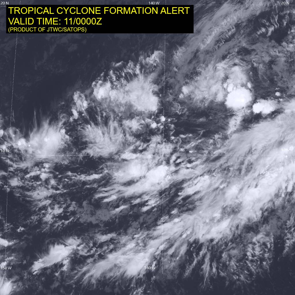
#Tropical #Pacific_Central #93C Area image 11/0300UTC, 24 hour rain estimate to 11/06UTC, 11/0001UTC tracks and GEFS 11/0001UTC 5+8 development probs.
11/06UTC image, 11/0001UTC tracks with GEFS and ECMWF 10/1800UTC ensemble.


#93C TCFA(HIGH)

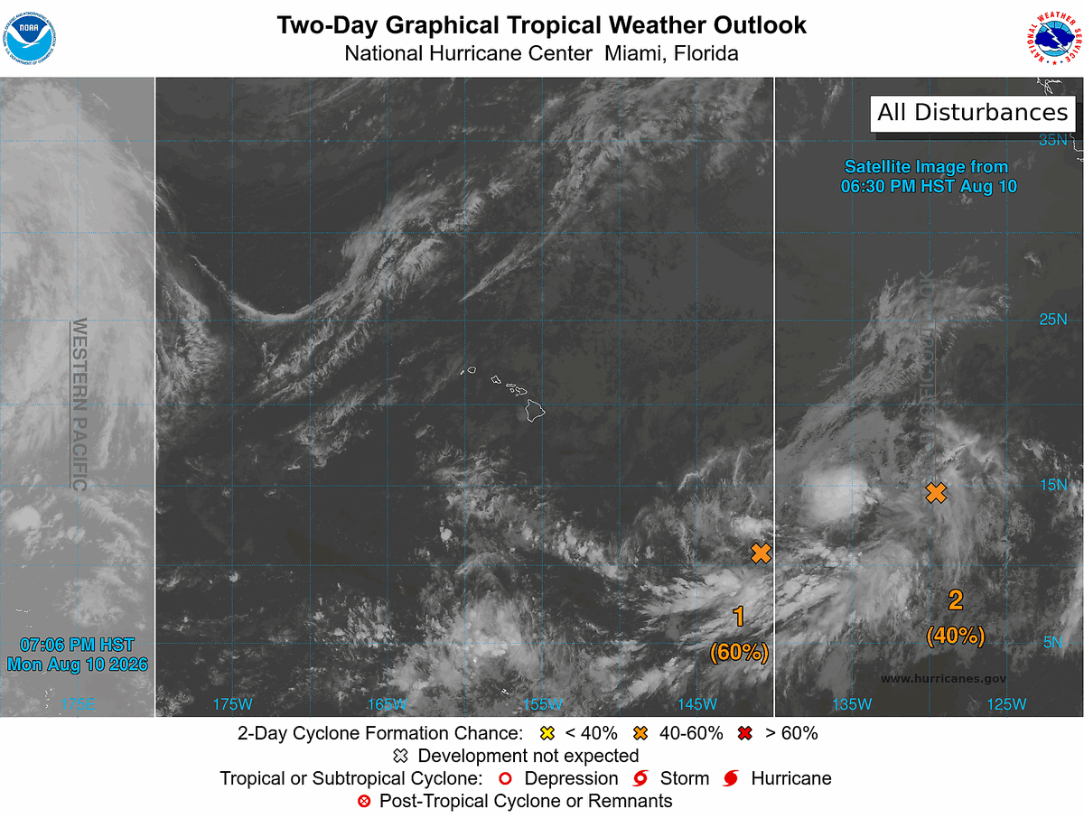
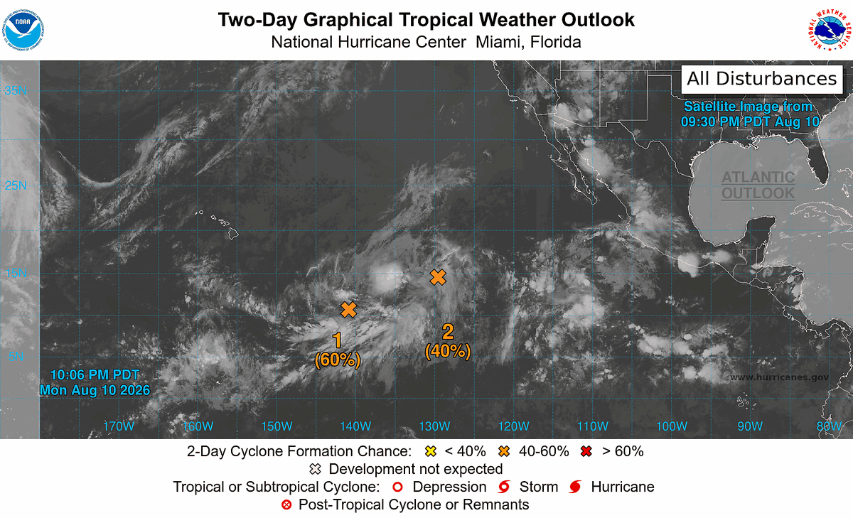

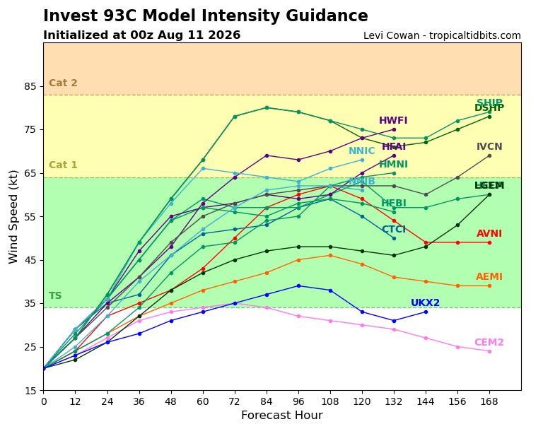
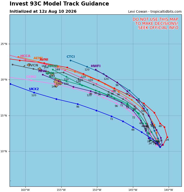
#Invest93C Model Track and Intensity Guidance Forecasts via @TropicalTidbits as of Monday 8/10/26 2PM HST #Storm #93C #Hawaii #HIwx


Invest #93C in the central Pacific Ocean has a 60% chance to develop into a Tropical Depression or Tropical Storm in the next 2 days and a 90% chance in the next 7 days as it produces light to moderate to heavy rainfall and gusty to damaging winds #tropicalupdate #wxtwitter #tropicswx #rainfall #severewx #wind #BREAKING


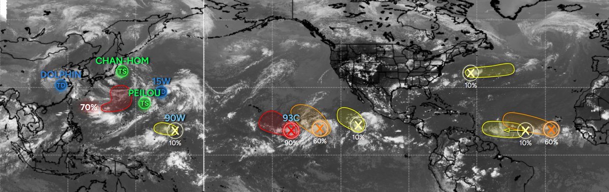
- System could develop behind Peilou within the next few days
- System next to #93C could become a depression this week
- System in the Main Development Region could become a depression late this week
- Various low pressures with low chances in the ATL and EPAC
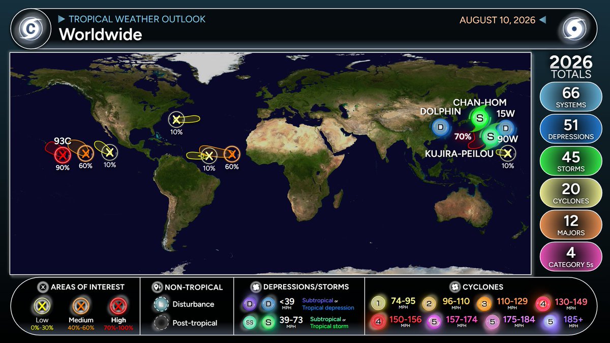

🌀 INVEST #93C / #LaLa
— #HAWAII TROPICAL THREAT
As of Monday, August 10, 2026
Invest 93C is a broad, increasingly organized area of low pressure approximately 1,100 miles east-southeast of the Hawaiian Islands. It is currently producing disorganized showers and thunderstorms, with conditions favorable for further development.
The latest information indicates that 93C is expected to become a TROPICAL DEPRESSION or TROPICAL STORM during the middle of this week as it begins moving generally west-northwestward to northwestward toward Hawaii.
🗓️ WHEN COULD HAWAII BE AFFECTED?
The most important period is now looking like:
Friday, August 14, 2026 → Sunday, August 16, 2026
Current forecast guidance suggests the system could begin producing significant effects around the Hawaiian Islands Friday August 14, 2026, with the potential for the most widespread impacts Friday night through the entire weekend, August 15-16, 2026.
Important: There is not yet a reliable LANDFALL zone. Some guidance keeps the strongest part of the circulation south of the islands, while other model solutions bring the system considerably closer to or across the island chain.
🌬️ WIND THREAT
The strongest winds would be concentrated near the eventual center and its strongest rainbands. A south-of-the-islands track could substantially reduce direct wind impacts while still producing dangerous surf, heavy rain and strong gusts.
🌊 SURF / STORM SURGE
Bery large swells could reach Hawaii, with estimates of approximately 16–20 feet of deep-water swell possible as the system approaches.
Dangerous surf is likely to arrive before the center of the tropical system reaches its closest point to Hawaii.
The greatest coastal concerns will include:
Dangerous breaking waves
Powerful rip currents
Coastal overwash
Beach erosion
Dangerous conditions for small boats
Possible coastal flooding in vulnerable locations
🌧️ RAINFALL / FLOODING
Heavy rainfall is another potentially significant threat.
Because 93C is currently a large and broad disturbance, rainfall impacts could extend well away from the center. If the circulation passes close to the islands, tropical moisture could produce:
Torrential rainfall
Flash flooding
Rapid rises in streams and normally dry channels
Mudslides and landslides
Road closures
Reduced visibility
Localized power outages
The mountainous terrain of the Hawaiian Islands makes flash flooding and landslides particularly important concerns, even if the strongest winds remain offshore.
🏝️ ISLAND-BY-ISLAND CONCERN
Island/Area Current concern
Hawaii Island 🟠 Potentially first significant impacts Friday; heavy rain, strong winds and dangerous surf possible
Maui / Molokai / Lanai 🟠 Increasing concern Friday night–Saturday; rainfall, surf and wind dependent on track
Oahu 🟠 Potential Saturday impacts; Honolulu could experience strong winds, heavy rain and dangerous surf if track shifts north
Kauai 🟡 Potential Saturday–Sunday impacts; highly dependent on track
Niihau 🟡 Potential Saturday–Sunday impacts depending on westward/northward track
Statewide 🟠 Everyone should monitor forecasts now
⚠️ WHAT PEOPLE IN HAWAII SHOULD DO NOW
This is the preparation stage — not necessarily an evacuation stage.
Residents should begin making sure they can respond quickly if watches or warnings are eventually issued.
NOW:.
Know your evacuation zone, particularly if you live in a coastal or flood-prone area.
Check emergency supplies.
Have several days of drinking water and nonperishable food.
Charge phones, battery packs and other essential electronics.
Check flashlights, batteries and emergency radios.
Secure outdoor furniture, loose objects and other items that could become airborne.
Review your household emergency plan.
Make arrangements for pets.
Check medications and other essential supplies.
Avoid unnecessary exposure to the ocean as surf begins increasing.
--------
Respectfully,
Roshin
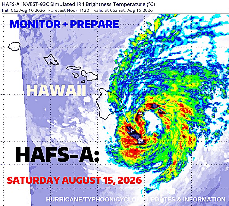

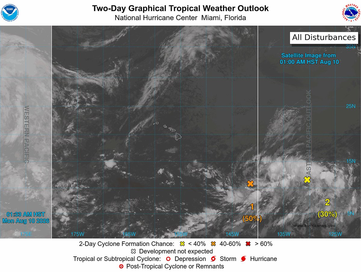
#93C (50/90); A TD is expected to form in the next few days. Interests in Hawaii should monitor the storm's progression.
EPAC AOI 2 (10/10); Development is unlikely to occur.
EPAC AOI 3 (30/60); A tropical depression could form over the next few days.
#wxtwitter


Some concerning trends in the latest AI model guidance, which now brings Invest #93C closer to Hawaii. The latest forecasts are now in better agreement with traditional numerical weather prediction models which bring the system dangerously close to the islands.


Key Messages have been released by the NHC on Invest #93C as the potential for a direct impact to Hawaii is looking more possible. There is still a lot of uncertainty with exactly will happen, but all of the major model guidance is showing a general track in the direction of...

Here is the forecast into early next week for the central Pacific Ocean according to the 12z US GFS model run and it is showing Invest #93C developing into a high end Tropical Storm/low end Hurricane and impacting Hawaii with moderate to heavy rainfall/gusty to damaging winds/large waves #tropicswx #tropicalupdate #BREAKING #severewx #wxtwitter #wind #flooding #rainfall #hawaii

Over in the Pacific, we're keeping a close eye on Invest #93C to the southeast of #Hawaii. There is high confidence in storm formation this week, but significant uncertainty in how it may impact the islands.
93C is embedded in a long trough axis, which is a major driver of uncertainty. Models are having some trouble narrowing down where along this axis the storm will eventually consolidate, and its future track will depend strongly on this. A general turn westward toward the Hawaiian islands is anticipated as a steering ridge becomes entrenched to the north, but how close the storm tracks to the islands remains uncertain.
While it's too early to know the details of how 93C may impact the region, it's smart to have a hurricane plan ready to go just in case and keep an eye on the forecast. I'll be monitoring closely from O'ahu.


Invest #93C now has a 50% chance to develop into a Tropical Depression or Tropical Storm in the next 2 days and a 90% chance in the next 7 days as it moves west and produces moderate to heavy rainfall and gusty to damaging winds #tropicalupdate #tropicswx #wind #rainfall #BREAKING #severewx #wxtwitter


#tropicalupdate august 10 2026 #Dolphin is gone, TD #Peilou spinning out in the ocean, same as #15W, Tropical Storm #ChanHom nearing #Japan, #90W well who knows why it is there, and #93c has a medium chance to develop in the next few days #tropics #tropicswx

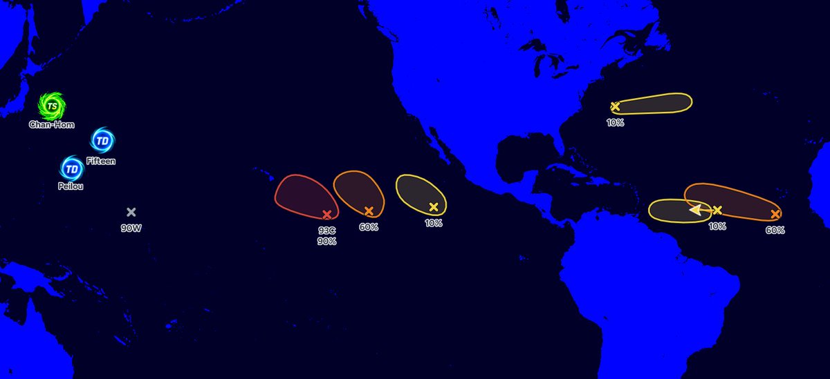

We also have lots of tropical waves/disturbances moving across the central Pacific Ocean capable of producing or have been producing or are currently producing light to moderate to heavy rainfall and gusty to damaging winds. Invest #93C has a 50% chance to develop into a Tropical Depression or Tropical Storm in the next 2 days and a 90% chance in the next 7 days #tropicalupdate #tropicswx #severewx #wxtwitter #wind #rainfall #BREAKING


🌀 #HAWAII #TropicalUpdate / #93C
— #Invest93C #Tropics
🕐 HAWAII TIME: 5:02 PM HST
📅 DATE: Sunday, August 9, 2026
━━━━━━━━━━━━━━━━━━━━
🌀 INVEST 93C — CENTRAL PACIFIC OCEAN
⚠️ CURRENT STATUS: Tropical disturbance / Invest 93C
📈 FORMATION CHANCE: 90% — HIGH
⏱️ FORMATION PERIOD: Next 7 days
🏷️ POTENTIAL NAME: TROPICAL STORM LALA
━━━━━━━━━━━━━━━━━━━━
🌀 CURRENT SITUATION
Invest 93C is a tropical disturbance located over the Central Pacific Ocean and is being closely monitored for possible tropical-cyclone development.
The disturbance currently has a 90% chance of developing into a tropical cyclone during the next seven days, placing it in the HIGH category for formation.
93C remains an invest/disturbance and has not yet been classified as a tropical depression or tropical storm.
━━━━━━━━━━━━━━━━━━━━
📊 CURRENT STATUS
🌀 Designation: Invest 93C
📈 Formation Probability: 90% — HIGH
💨 Maximum Sustained Winds: Not verified in the latest available official information
📉 Minimum Pressure: Not verified
🧭 Movement: Not verified
📍 Exact Coordinates: Not verified
━━━━━━━━━━━━━━━━━━━━
🌀 POTENTIAL DEVELOPMENT
Conditions will be closely monitored for additional organization of the disturbance.
Should Invest 93C develop into a tropical depression and subsequently reach tropical-storm strength, the next available Central Pacific name is:
🌀 LALA
Pronunciation: LAH-lah
━━━━━━━━━━━━━━━━━━━━
🌺 HAWAII THREAT ASSESSMENT
⚠️ CURRENT THREAT TO HAWAII: NOT DETERMINED
There is currently no indication that Hawaii is under a tropical-cyclone watch or warning because of Invest 93C.
The 90% formation probability refers to the likelihood that the disturbance will become a tropical cyclone — it does not mean there is a 90% chance of a Hawaii landfall or direct impact.
The eventual threat to the Hawaiian Islands will depend on:
• Development and organization of the system
• Steering currents across the Central Pacific
• Forward movement and track
• Wind shear
• Ocean temperatures
• The system's eventual intensity
━━━━━━━━━━━━━━━━━━━━
🚨 PREPAREDNESS
Residents and visitors across the Hawaiian Islands should remain weather-aware and continue monitoring official information as Invest 93C develops.
No emergency preparations for a direct Hawaii impact are warranted solely from the current information.
However, because tropical systems can chĺange in organization, intensity, and track, residents should remain prepared to act if future forecasts indicate an increasing threat.
━━━━━━━━━━━━━━━━━━━━
🌀 BOTTOM LINE
INVEST 93C IS A SIGNIFICANT TROPICAL DISTURBANCE IN THE CENTRAL PACIFIC WITH A 90% CHANCE OF TROPICAL-CYCLONE FORMATION DURING THE NEXT 7 DAYS.
If the system develops and reaches tropical-storm strength, it would be named LALA.
HAWAII IS NOT CURRENTLY UNDER A TROPICAL-CYCLONE WATCH OR WARNING FOR INVEST 93C.
Respectfully,
Roshin
Residents should continue monitoring the Central Pacific Hurricane Center + National Hurricane Center-Miami + Hurricane/Typhoon/Cyclone Updates & Information for subsequent advisories.
━━━━━━━━━━━━━━━━━━━━
🌀

Last Seen Hashtags on Sotwe
bbc mature
Seen from Algeria
bleached
Seen from Chile
nolimits((*)) +filter:native_video
Seen from Germany
momsonn
Seen from United States
qos
Seen from United States
omegle
Seen from Mexico
野生のイルカ
Seen from Pakistan
เงี่ยนหีแม่
Seen from Thailand
ordugay
Seen from Turkey
noelkampton
Seen from Thailand
Trends for you
Most Popular Users

Elon Musk 
@elonmusk
241.2M followers

Barack Obama
@barackobama
119.1M followers

Cristiano Ronaldo
@cristiano
112.9M followers

Donald J. Trump
@realdonaldtrump
111.8M followers

Narendra Modi
@narendramodi
107.1M followers

Rihanna
@rihanna
98.3M followers

NASA
@nasa
92.3M followers

Justin Bieber
@justinbieber
91.5M followers

KATY PERRY
@katyperry
89.1M followers

Taylor Swift
@taylorswift13
83M followers

Lady Gaga
@ladygaga
74.5M followers

Virat Kohli
@imvkohli
72M followers

Kim Kardashian
@kimkardashian
70.5M followers

YouTube
@youtube
68.8M followers

Neymar Jr
@neymarjr
64.9M followers

Bill Gates
@billgates
64.6M followers

The Ellen Show
@theellenshow
62.4M followers

Selena Gomez
@selenagomez
62.1M followers

CNN
@cnn
61.8M followers

X
@x
60.8M followers