

Top Tweets for #93c

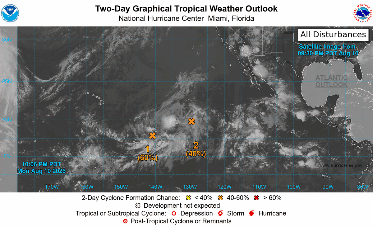
#93C (70/90); A depression is expected to form over the next few days. Interests in #Hawaii should closely monitor the storm's progression.
#99E (70/70); JUST IN- A special update issued by the NHC boosts it to 70/70, noting a depression is likely to form by tomorrow.
#wxtwitter
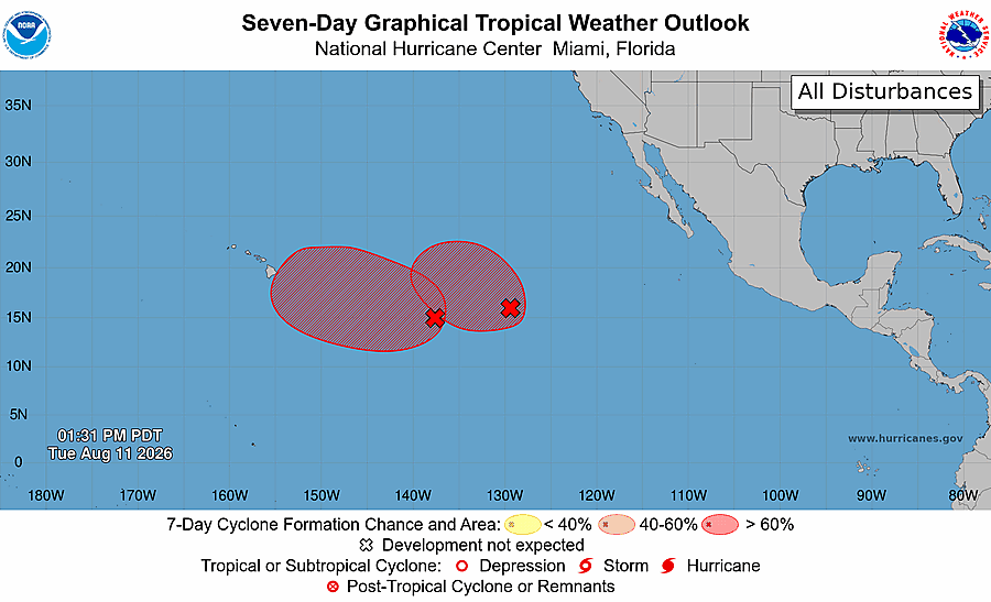


Today's tropical weather outlook video is now out on Youtube, going over our eastern Atlantic tropical wave AND Invest #93C which is becoming a likely threat to Hawaii. Don't miss it! -
https://t.co/i8dtreDtCv

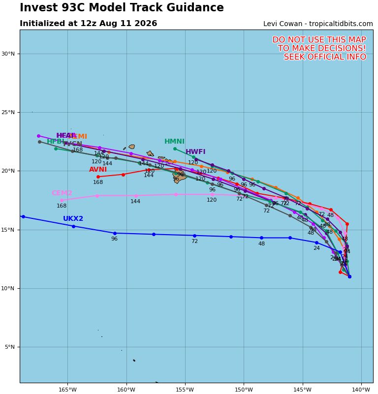
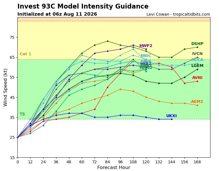
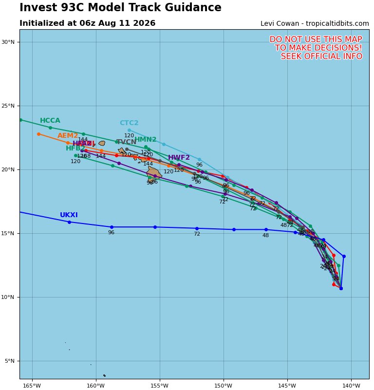
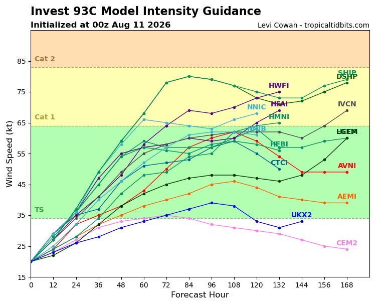
#Invest93C Model Track and Intensity Guidance Forecasts via @TropicalTidbits as of Tuesday 8/11/26 2AM HST #Storm #93C #Hawaii #HIwx


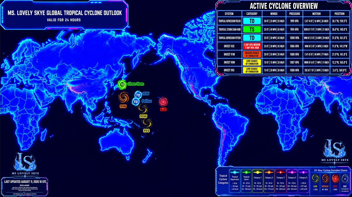

Invest #93C remains a large and disorganized system, consisting of an elongated SW-NE trough segment with an area of stronger rotation and convection at its northeastern cusp. Models remain in good agreement that this area will ultimately coalesce into a tropical storm over the next couple of days and move towards #Hawaii, but the exact track remains uncertain. In this type of scenario, models tend to struggle with the details of where and when such a broad/unstable trough will consolidate. Once a storm does form, that "launching point" will mostly determine where the storm tracks relative to #Hawaii. The majority of models today do show impacts to the state.
Environmental conditions will likely favor some intensification once 93C becomes a tropical cyclone, with the ultimate peak intensity depending on the time of formation, its track relative to the Hawaiian Islands and their tall topography, and the storm's interaction with an upper-level trough pinching off north of Hawaii. These details will begin to come into focus once a vortex consolidates. For now, it's best to prepare for a potential storm event throughout Hawaii, likely occurring during this weekend.


Invest #93C remains broad and stretched out, as it is imbedded along within the monsoon trough in the Pacific. Models however, have consolidated on a track that ends up taking this storm directly towards Hawaii. Where exactly the LLC ends up consolidating will impact the track...


🌀 #HAWAII TROPICAL ALERT
— INVEST #93C / #TropicaUpdate
⚠️ INCREASING THREAT OF A STRONG TROPICAL STORM OR CATEGORY 1 HURRICANE
📅 Potential Impact Period: Friday, August 14 – Monday, August 17, 2026
🌀 Potential Storm Name: LALA
There is growing concern that 93C could strengthen into a Strong TROPICAL STORM or Category 1 HURRICANE, with 65–80 MPH sustained winds and higher gusts over exposed coastal areas and higher elevations.
The exact track, intensity and timing remain uncertain. However, the potential for significant impacts across Hawaii is increasing, and residents should begin preparing now.
🌬️ WIND IMPACTS
Potential sustained winds: 65–80 MPH
Strong TROPICAL STORM-force to HURRICANE-force winds could produce:
• Downed trees and power lines
• Power outages
• Roof and structural damage
• Damage to signs, utility poles and outdoor structures
• Dangerous driving conditions
• Disruptions to airports, harbors and inter-island transportation
Higher elevations and exposed coastal areas could experience stronger wind gusts.
🌊 STORM SURGE
A preliminary scenario could produce approximately 1–3 feet of STORM SURGE.
🌊 LARGE SWELLS & DANGEROUS SURF
Offshore wave heights could potentially reach 15–20+ feet across exposed waters.
🌧️ HEAVY RAINFALL
A preliminary rainfall scenario could produce 2–6 inches of rain across portions of the islands, with locally higher totals of 6–10+ inches possible.
• Flash flooding
• Rapid rises of streams and rivers
• Urban flooding
• Mudslides and landslides
• Road closures
• Debris flows
⛰️ LANDSLIDES
A significant threat of landslides, falling trees and infrastructure damage in mointainous terrain.
🏝️ ISLAND-BY-ISLAND CONCERN
🌋 HAWAIʻI ISLAND 🟠
Potential impacts: Friday, August 14 – Saturday, August 15
Potentially among the first islands to experience deteriorating conditions. Heavy rain, strong winds, dangerous surf, large swells and localized flooding could develop first across exposed areas.
🌺 MAUI / MOLOKAI / LANAI 🟠
Potential impacts: Friday night, August 14 – Saturday, August 15
Increasing concern for heavy rainfall, strong winds, dangerous surf and large swells. Flash flooding and landslides could become significant concerns depending on the eventual track.
🏙️ OʻAHU 🟠
Potential impacts: Saturday, August 15 – Sunday, August 16
Strong winds, heavy rainfall, dangerous surf and large swells could affect Oʻahu. Honolulu and surrounding communities could experience stronger conditions if 93C/Lala tracks farther north.
🌴 KAUAʻI 🟡
Potential impacts: Saturday, August 15 – Sunday, August 16
Potential for increasing rainfall, strong winds, dangerous surf and large swells. Impacts remain highly dependent on the eventual track.
🏝️ NIʻIHAU 🟡
Potential impacts: Saturday, August 15 – Sunday, August 16
Potential for strong winds, dangerous surf, large swells and periods of heavy rainfall, particularly with a more westward or northward track.
🌀 STATEWIDE HAWAII 🟠
Potential impact window: Friday, August 14 – Monday, August 17
All Hawaiian Islands should closely monitor Invest 93C. A shift in the track could significantly change which islands experience the strongest winds, heaviest rainfall, highest surf and greatest coastal impacts.
⚠️ WHAT PEOPLE IN HAWAII SHOULD DO
✅ Review your emergency plan
✅ Check emergency food and water supplies
✅ Have flashlights, batteries and backup power available
✅ Secure outdoor furniture and loose objects
✅ Prepare for possible power outages
✅ Know your evacuation routes and shelter options
✅ Monitor official forecasts and emergency-management information
✅ Avoid dangerous coastal waters as swells increase
✅ Be prepared for flooding, landslides and transportation disruptions
🚨 IMPORTANT FORECAST DISCLAIMER
Blog subject to change.
Follow the Central Pacific Hurricane Center and Hurricane/Typhoon/Cyclone Updates & Information for updates 24/7.
Respectfully,
Roshin


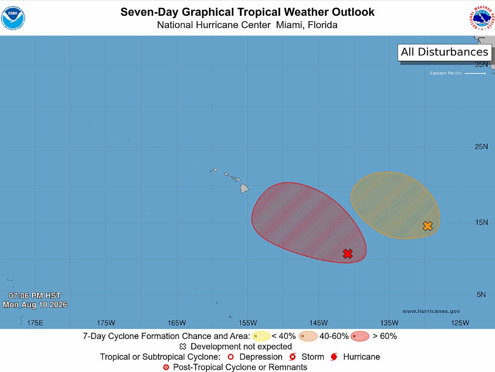
All eyes on invest #93C southeast of the Hawaiian Islands as most guidance produces a weekend threat. There is a large cluster to the east of 93C also being watched development that will be interesting if it hinders or aides 93C.
There is a high altitude surveillance mission scheduled for later today that should put new data into these models runs starting tonight so that could give us a little more confidence into what is already a clustered model suite over the Hawaiian Island chain. Intensity guidance still suggests high end TS or low end hurricane possible.
@weatherbell @TropicalTidbits

#Invest93C Model Track and Intensity Guidance Forecasts via @TropicalTidbits as of Monday 8/10/26 8PM HST #Storm #93C #Hawaii #HIwx

#Tropical #Pacific_Central #93C GFS and HFSA 11/0001UTC accumulated precipitation animation (https://t.co/TjRNezW40A)
#Tropical #Pacific_Central #93C Area image 11/0300UTC, 24 hour rain estimate to 11/06UTC, 11/0001UTC tracks and GEFS 11/0001UTC 5+8 development probs.
11/06UTC image, 11/0001UTC tracks with GEFS and ECMWF 10/1800UTC ensemble.


#93C TCFA(HIGH)

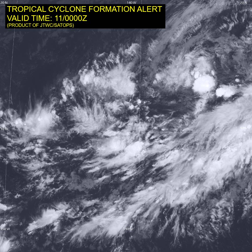
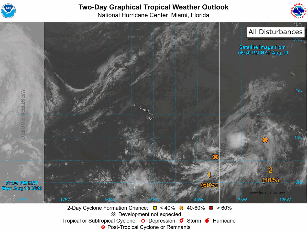
#Invest93C Model Track and Intensity Guidance Forecasts via @TropicalTidbits as of Monday 8/10/26 2PM HST #Storm #93C #Hawaii #HIwx


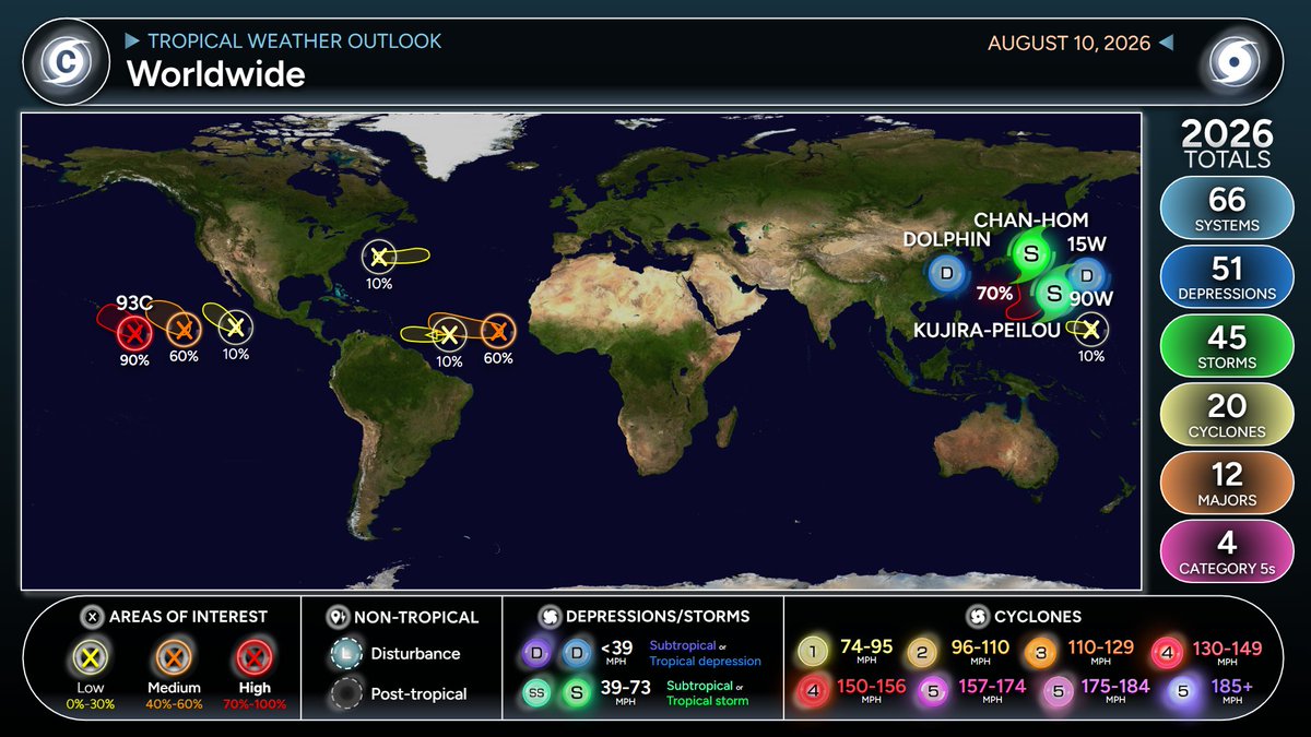
Invest #93C in the central Pacific Ocean has a 60% chance to develop into a Tropical Depression or Tropical Storm in the next 2 days and a 90% chance in the next 7 days as it produces light to moderate to heavy rainfall and gusty to damaging winds #tropicalupdate #wxtwitter #tropicswx #rainfall #severewx #wind #BREAKING


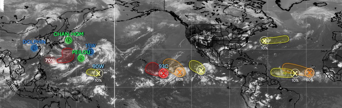
- System could develop behind Peilou within the next few days
- System next to #93C could become a depression this week
- System in the Main Development Region could become a depression late this week
- Various low pressures with low chances in the ATL and EPAC
Last Seen Hashtags on Sotwe
BREEDING
Seen from Netherlands
ฝาก3รับ50
Seen from Thailand
girlcock tnwo filter:native_video
Seen from United States
鵠沼蘭
Seen from Korea
porn
Seen from Mexico
ifşa izle
Seen from Turkey
ankaratraveſti
Seen from Turkey
gaziantep
Seen from India
Teenage() +filter:native_video
Seen from Turkey
manavgatgay
Seen from Turkey
Most Popular Users

Elon Musk 
@elonmusk
241.3M followers

Barack Obama
@barackobama
119.1M followers

Cristiano Ronaldo
@cristiano
113M followers

Donald J. Trump
@realdonaldtrump
111.8M followers

Narendra Modi
@narendramodi
107.1M followers

Rihanna
@rihanna
98.3M followers

NASA
@nasa
92.3M followers

Justin Bieber
@justinbieber
91.5M followers

KATY PERRY
@katyperry
89.1M followers

Taylor Swift
@taylorswift13
83M followers

Lady Gaga
@ladygaga
74.5M followers

Virat Kohli
@imvkohli
72M followers

Kim Kardashian
@kimkardashian
70.5M followers

YouTube
@youtube
68.8M followers

Neymar Jr
@neymarjr
65M followers

Bill Gates
@billgates
64.6M followers

The Ellen Show
@theellenshow
62.4M followers

Selena Gomez
@selenagomez
62.2M followers

CNN
@cnn
61.8M followers

X
@x
60.8M followers