Top Tweets for #Dronemapping

Think you know GIS, Drone Mapping, and Photogrammetry? Discover the essential terms every geospatial professional should know. Which one do you use most? #GIS #DroneMapping


📲 Contact GeoStore today for expert recommendations and pricing.
#DroneMapping #GISNigeria #Surveying #RTK #LeicaBLK360 #GarminGPS #DJIMatrice400 #GeoStore

Choosing the Right RGB Sensors for Your #Surveying Needs!
https://t.co/yBDsopiZzm
#PLI #Wingtra #Geospatial #SurveyLife #Surveying #LandSurveying #Drone #Drones #DroneLife #DroneSurvey #DroneSurveying #DroneMapping #DroneLiDAR #UAVLiDAR #UAVSurvey #UAVMapping #UAS #NSPS #PLS


Vuna Wharf, Nukuʻalofa-Tonga’s main gateway for cruise ships and cargo, now mapped in stunning high-res detail. Data like this supports coastal monitoring and smarter infrastructure planning
Tongatapu, Tonga|@ThisIsPLACE
#Tonga #Nukualofa #DroneMapping #OpenData #PacificIslands


📊The ROI of Drones Isn't the Flight—It's the Decision. 🏗️https://t.co/UsNlktFmrd
#CommercialConstruction
#DroneMapping
#ConstructionTech
#ProjectManagement
#ConstructionInnovation


🚀 Take your surveying skills to the next level with our co-funded Drone Mapping Course! Fly the DJI Mini, see enterprise drones in action, and get CAA-accredited with Iprosurv.
📩 [email protected]
| 📞 0114 4055 007
#DroneMapping #CoFundedLearning #STEM #Iprosurv @DJIGlobal

Dense palm canopy. No ground visibility. No problem. 🌴
DJI Zenmuse L3 cuts through what cameras can't, mapping every drainage channel and contour from a single pass.
This is LiDAR, the way it should work.
#djienterprise #zenmusel3 #lidar #dronemapping #aerialsurvey

YOLOv8-Based Object Detection from UAV Aerial Imagery | Computer Vision & Artificial Intelligence. Tutorial Link: https://t.co/1MCMnkT7iN
#YOLOv8 #ComputerVision #ArtificialIntelligence #DeepLearning #UAV
#DroneMapping #RemoteSensing #GeospatialAI #ObjectDetection


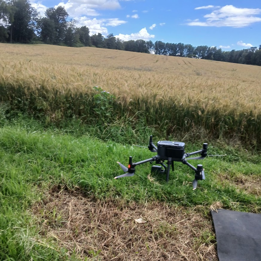
Drone mapping over wheat fields using UAVs enables precision agriculture through high-resolution geospatial data for better farming decisions.
#DroneMapping #GIS #PrecisionAg #UAV #Surveying

Mapped an entire solar farm in a day 🚁
Now the team can see exactly where grass needs reseeding—no boots on the ground needed.
Overlay + zoom = zero guesswork.
Learn more: https://t.co/0xKXLT7fu0
#solar #dronemapping #solarenergy #dronedata #drones

StockpileStudio with PixElement auto-detects stockpiles from terrain, lets you refine boundaries fast, and generates volume reports. Assign material, density, and cost to convert volumes into mass and value.
#DroneMapping #Photogrammetry #Surveying #Mining #StockpileMeasurement

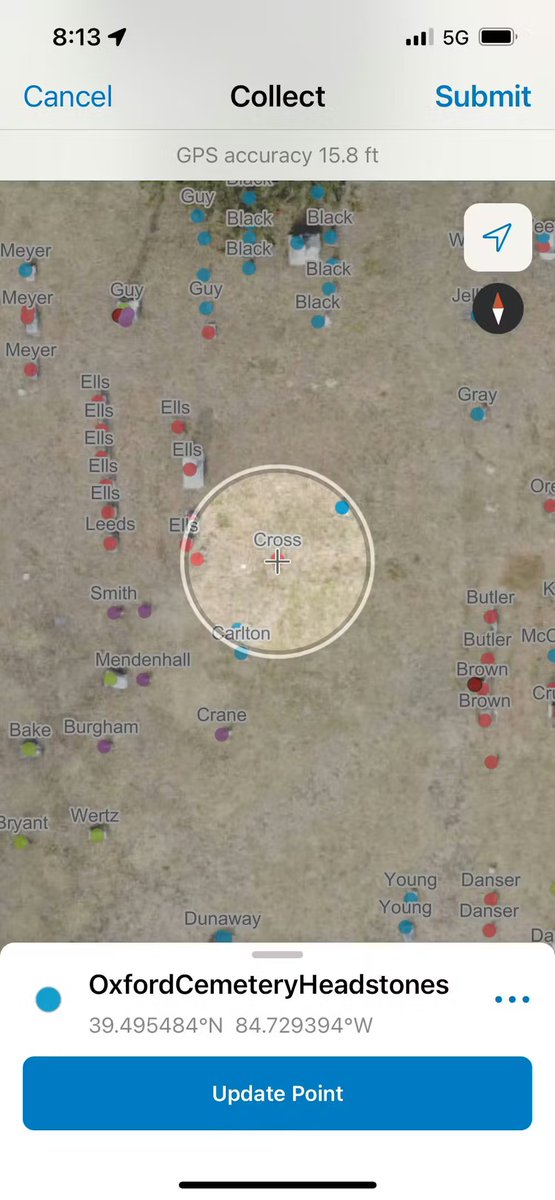
Students mapped 6,000+ headstones using phones and drones — in half the usual time 📱🚁
Learn more:
https://t.co/52XGMctc3O
#Geoawesome #GIS #DroneMapping #Cartography

Expose Now Exclusive: सीकर में माफिया का 'पत्थर' वाला खेल; सरकार को 132 करोड़ की चपत, ड्रोन ने खोली पोल!...
#SikarNews #MiningScam #RajasthanMafia #BreakingNews #ExposeNow #DroneMapping


🚧 Are you getting the most value from your drone program?
👉 Discover how leading infrastructure teams are scaling their drone programs.
🔗 https://t.co/wjKhPPwXpR
#ConstructionTechnology #DroneMapping #DigitalConstruction
🔹 Pix4D = The Industry Standard for surveying
Whether you're mapping in Lagos, Abuja, or Port Harcourt, we’ve got you covered. Get your official licenses today.
🔗 https://t.co/h81Y7qEz4T
#DroneMapping #GeospatialNigeria #SurveyingLagos #GeoStore #Abuja #GIS #SB19 Elenga
How to Process Drone Imagery Data for Free – Step-by-Step Guide?
Tutorial link: https://t.co/Q7DvPiz24W
Registration link: https://t.co/O4AcVIerFn
#dronemapping
#UAV
#dronedata
#photogrammetry
#gis
#remotesensing
#Geospatial
#dronesurvey
#DroneProcessing
#EarthObservation

Accurate land use mapping helps farmers and developers understand the full potential of their land and plan more effectively.
#dronemapping #agriculture
🚧 Are you getting the most value from your drone program?
👉 Discover how leading infrastructure teams are scaling their drone programs.
🔗 https://t.co/tTuNROL0Au
#ConstructionTechnology #DroneMapping #DigitalConstruction

Learn more about drone property surveys and how the ZenaDrone 1000 can make your inspections accurate, reliable, and cost-effective.
Book a demo now: https://t.co/imbNwdlwMV 🔗
#ZenaDrone #PropertySurvey #DroneMapping #AerialSurvey #RealEstateTech

📦 Real-World Application
A drone fleet in the Philippines now uses GeoPulse to map landslide-prone zones.
On-chain GPS = faster response, verifiable evidence.
#GeoPulse #DisasterTech #DroneMapping

Most Popular Users

Elon Musk 
@elonmusk
240.6M followers

Barack Obama
@barackobama
119.3M followers

Donald J. Trump
@realdonaldtrump
111.7M followers

Cristiano Ronaldo
@cristiano
110.4M followers

Narendra Modi
@narendramodi
107M followers

Rihanna
@rihanna
97.6M followers

NASA
@nasa
92.2M followers

Justin Bieber
@justinbieber
90.9M followers

KATY PERRY
@katyperry
87.6M followers

Taylor Swift
@taylorswift13
81.4M followers

Lady Gaga
@ladygaga
72.9M followers

Kim Kardashian
@kimkardashian
69.7M followers

Virat Kohli
@imvkohli
69.7M followers

YouTube
@youtube
68.7M followers

Bill Gates
@billgates
63.8M followers

Neymar Jr
@neymarjr
62.5M followers

The Ellen Show
@theellenshow
62.5M followers

CNN
@cnn
61.9M followers

X
@x
60.8M followers

Selena Gomez
@selenagomez
60.7M followers