

Top Tweets for #GeophysicalEvent

@BladeoftheS um...maybe not. Data centers don't need fresh water but underground bases and cities...will. #geophysicalevent #micronova #polereversal
https://t.co/1AfzMe5iKL

China has 400?
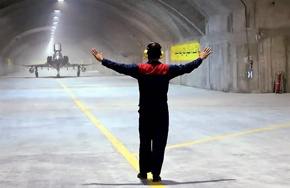
Irans new underground Air base?
Underground US Bases?
Can this list be true?
Not sure where I aquired this, but it was either a post or sent to me via Email, as I have it as a text file. I never really checked it out. I would love some feedback on whether this is real or not?
ARIZONA
1. Fort Huachuca. 31°50′ N 1100 19'48" W, saucer base below, intelligence training above, mind control included.
2. Gates Pass Base
3. Gila Mountain Area, south of Interstate 8 and approximately 30 east of Yuma, AZ. 290N 116ºW. DUM base.
4 . Grand Wash Cliffs, on the western edge of the cliffs at the head of Grapevine Wash. Must be accessed via Highway 93 and then dirt roads. DUM base. Page 303…
5 . Green valley
6. Hualapai Mountains, east side of the range, about 35 miles (56 km). SE of Kingman, AZ
7. Rincon Mtn., north side of Rincon Mtn
8. Mt Lemon
10. Safford, near Safford
11. Santa Catalina Mountains – Base
ARKANSAS
12. Near Hardy and Cherokee Village. 360 19′ N 9°29'W W. Installation purpose unknown.
13. Pine Bluff, Arkansas area. 34° 13.4′N 92° 01.0'W to 34° 30′N 92° 30'W. Saucer base.
CALIFORNIA
14. 29 Palms Marine Base, identified on the military map as airspace area R-2501 N. Saucer base southeast of Ludlow. This is a US alien research/diagnostic facility and UFO base.
15. China Lake, mind control and weapons research
16. Darwin, California, 4 miles west of Darwin
17. Deep Springs, CA, 37°22′ N 117º 59.3′ W. Saucer base
18. Fort Irwin, CA, 35°20'N 116°8'W. Saucer base
19. Edwards Air Force Base, in the area where Diamond Cr. & that so. There are three underground UFO bases at the Yuba meeting junction. 34°8′N 117°48′W
20. George Air Force Base, California – Saucer Base
21 . Helendale, Lockhead Underground Facility, 34º44.7′ N 1170 18.5′ W. Technology for secret projects. There are 3 saucer bases here.
22. Los Angeles: Take Hwy 14 toward Edwards AFB to Palmdale, and after taking several blocks to 170th Street, go north on 170th Street to the Rosamond-1 and 70th intersection takes the second, lower and better maintained dirt road you go west and if you turn right at the power lines north and go up the hill you will see the top of an underground NORTHOP facility; Technology for the elite's secret projects. This area was very active in the 1970s. Northrop's facility is near the Tehachapi Mountains. The value has been reported to drop by 42 levels. It is heavily involved in electronics and high-tech aerospace research.
23 . Mt Shasta
24. Kern River, California, the hollowed out mountain adjacent to the hydroelectric facility at the Kern River Project near Bakersfield - reported saucer base
25. Napa Valley – Located in Oakville Grade north of Napa, California. Tunnels also connect the wineries north of Napa and are used for white slavery and mind control. Has a saucer base.
26. Norton Air Force Base – Saucer Base
27 . Quincy, CA, 39° 56.2′ N 120° 56.5′ W. Saucer base
28 . Near Palmdale (if you take Palmdale Blvd. to 240th St. and go to Ave. R-8. On the eastern border of Ave. R-8 is the McDonnell-Douglas facility called the Uano Facility. From You can see them better from the Three Sisters. To the south of the complex, strangely shaped disks protrude from the ground that glow and change color.
29. Presidio, California - A FEMA/DOD site for the Region IX regional office
30. San Bernardino, CO, 34° 50′ N to 34° 16′ N
31. Santa Barbara County – lies in the thick diatomaceous earth layers
32. Santa Rosa, 38º 26.4′ N 122º 42.9′ W, FEMA, West Coast Regional Center What FEMA does is largely kept secret. This is listed as a communications antenna array, but it does much more than that.
33 . Sierra Nevada Mountains, California – very deep military base
34. Tehachapi Ranch - 4 saucer bases, Tecachapi Canyon features a new underground base completed in September 1995. This is the Orion Unholy 6 base. 35° 20′ 118° 40′
35. Trona, California, 35° 45.5′ N 1 77º22.6′ W - several miles northwest of Trona, just below Argus Peak. This DUM is located on China Lake NWC land and may have been built in the 1960s.
COLORADO
36 . Alamosa, 37° 28.1′ N 105° 52.2′ W – reported saucer base
37. Book Cliffs, CO, 39° 40′ N 108º 0′ W near Rifle, CO
38. Boulder, CO - The headquarters of EMC, a form of electromagnetic mind control broadcast to alter the minds of Americans and control slaves.
39 . COLORADO SPRINGS, NORAD - Canada and USA, and FEMA, hundreds of personnel, cover at least 4.5 cubic miles of underground caverns and 45 underground steel buildings. Many underground chambers are up to 50 x 100 feet in size. This complex tracks thousands of satellites, missiles, submarines and UFOs. NORAD also controls many Monarch slaves that have ALEX, JANUS and ALEXUS end-time callback programming. The NORAD facility has 1,278 miles of underground road.
40 . Fort Collins – base for gray aliens41 . Grand Mesa – Orion Saucer Base
42. Montrore Co. – north of Paradox, in Paradox Valley. The Paradox Valley location is accessible via highway. 90 about Nucla. Page 304…
CONNECTICUT
43. Northwest Connecticut
FLORIDA
44. Solid Base – specified saucer base
45. Eglin AFB, 30° 40′ N 86° 50′ W – Orion saucer base since 1978
GEORGIA
46. Atlanta, GA – FEMA Regional Center, appropriately placed as Atlanta is set to become a capital city as part of the NWO's redrawing of boundaries. Atlanta is believed to have several underground facilities in its area, one north at Kennesaw Mtn., Marietta, GA, connected to Dobbins AFB, and one south of Atlanta in Forest Park.
47. Thomasville, 30° 50.2′ N 83° 58.9′ W, FEMA regional center, training groups in search and destroy missions in the event martial law is declared. This is southwest Georgia in the area of the tunnels.
IDAHO
48. Lower Goose Lake area in the general area of Oakley, ID. – Wackenhut of the Illuminati operates a “model prison” for the NWO. The worst federal prisoners are housed in this underground prison, which has 7,100 cells filled with approximately 2,700 federal inmates. A track runs right through the middle of the eerie underground complex. Food and showers are available on the tracks, and the men are allowed to shower once a week. Minimal lighting is used and the men are knocked unconscious if they speak at all. It lies 500 feet underground.
49. South-central Idaho – beneath the lava flows of the Snake River between Twin Falls and Idaho Falls.
INDIANA
50. Bedford & Lawrence Co. Area - continued activity in large old mines suggests possible government use of the large old quarries.
KANSAS
51. Atchison, KS - the underground DIPEF facility that the Govt. would run in an emergency. AT&T maintains an underground facility in Fairview, Kansas.
52. Kinsley – an underground UFO base
MARYLAND
53. Camp David – just north of the camp is an underground facility that is important to the secret services.
54th at Ft. Meade of the National Security Agency, 10 acres of the most advanced supercomputers that can be built, very large complex, massive surveillance of all worldwide communications, including all U.S. and world transmissions of telephones, telegraphs, telexes, faxes and radios, TV and microwave broadcasts.
55. Olney, actually the facility is between Olney and Laytonsville, on Riggs Road. away from RT. 108. There could also be another underground facility in the area, FEMA and possibly NSA, the facility could be 10 stories deep, purpose unknown.
56. Suitland, MD – US Government Secret Archives. stored here in underground levels. Vaults contain large amounts of documents that are not indexed. Restricted access with a coded security card. High-level intelligence groups also operate in the area.
MASSACHUSETTS
57. Maynard, 42° 26.0′ N 71° 27.0′ W FEMA, regional center, Wackenhut is also here.
MICHIGAN
58. Battle Creek, 42° 19.3′ N 85° 10.9′ W FEMA, Regional Center, Activity Secret (not validated)59. Gwinn, Ml, 46° 16.8′ N 87° 26.5′ W, there is a large underground base near Gwinn that is an important base for sending signals. An AFB is also nearby. There is an alien base beneath Lake Superior with roads 5,000 feet deep.
MISSOURI
60 . 12 miles south of Lebanon, 36° 02.8′ N 115° 24.3′ W, near the newly founded town of Twin Bridges, a saucer base61. In the Bat/Dry/Dead Man/Howell cave group - reported saucer base62. St. Francis Mountains, MO (between St. Louis and New Madrid)
NEBRASKA
63. North Central Nebraska64 . Red Willow Co. near McCook, NE
NEVADA
65. Blue Diamond, 36°02.8'N 115°24.3W - reported saucer base
66-68. Groom Lake, also known as Dreamland, Area 51, The Area, The Spot, Red Square, Sally Corridor, Watertown Strip. 1150 50'N 37°20W. Led by the NWO along with demonic beings, the CIA is there and Wackenhut Security. Two major underground facilities near Groom Lake, but separate from it but controlled by the demonic entities, are the Papoose Range and Cockeyed Ridge underground bases (S-4). The purpose is to test various UFOs and other secret aircraft such as Aurora and Stealth.Biological work is also carried out, including the organic rearing of small gray horses. Many levels were built for these three complexes, and a 7-mile running track (actually 39 miles) was built over Groom Lake, a dry lake. There are an S-2, an S-4, an S-6 and an S-66 underground facilities. S-66 is the most secret cave with 29 levels and a depth of 11,300 feet.
69 . Quartzite Mountain southeast of Tonopah, 37° 31′ N 116° 20′ W – reported saucer base
70. Tonopah, Air Force, CIA? & ??, deals with secret aircraft
NEW HAMPSHIRE
71-73. There could reportedly be as many as three underground facilities in the hills of New Hampshire.
NEW JERSEY
74. Picatinny Arsenal, 4o° 38′ N 74° 32′ W – Saucer base, 1/4 cubic mile in size and very deep underground.
NEW MEXICO
The states of New Mexico and Colorado were used to build a series of underground bases. (All other states have this too.) The primary underground facilities in New Mexico consist of: 3 huge underground bases in:The Dulce, NM area (an area I surveyed for several days in 1993). The White Sands-Alamogordo area with three underground bases. Datil and Pie Town, which have two other underground bases. (Carlsbad Cavern, which had underground activity that has reportedly been discontinued, and another base east of Carlsbad.) The underground facility in the Los Alamos area. the underground facility in the Taos area There are basically four subway systems in the New Mexico region. Go to the Four Corners area and then to Groom Lake (Area 51). Head north towards Delta, Colorado and Colorado Springs. The Taos facility runs roughly north along Interstate 25 and eventually flows into NORAD. The southern bases connect Texas and Mexico.
The Los Alamos facility dates back to at least 1940. One can only imagine what half a century of work was built in this underground system. Visitors to the deeper levels report people being held in glass cylinders and many other strange things. I had the opportunity to interview some people who had been in the lower levels of some of these facilities. There are special badges, special uniforms, subway elevators, etc. which I won't describe in detail due to time constraints. .
75. Angel Peak – reported saucer base. Carlsbad Cavern area (now destroyed), 32° 25.0'N 1040 14.0W -old saucer base relics remain.
78. Dulce, NM, 36º 56.0'N 106°59.8'W, – South of Dulce, in the area of the Jicarilla Indian Reservation, is another facility several miles east of the Dulce facility. This is run directly by the Illuminati with the help of the Army and Air Force, the CIA also conducts experiments at the center; The size of the facility is huge and requires small shuttle trains. According to witness statements, it has seven levels. Serves as a UFO base, biological experiments, production center for small gray drones. Wackenhut ensures some of the security on site.
79. Kirtland AFB, NM, Sandia National Lab
80. Manzano Mtn, near Albuquerque, known as Kirtland Munitions Storage Complex, Airforce, 3,000 acre base within Kirtland AFB/Sandia National Labs complex, guarded by 4 deadly fences, uses unknown, suspected UFO base. A new 285,000 square foot building. ft. bunker is being built near the Manzano base.
81. Pie Town, 34° 17.9′ N 1 108° 08.7′ W, near Pie Town, UFO base.
82. Sandia Mountains northeast of Albuquerque - alleged saucer base
83. North of Taos Pueblo
84 . White Sands, 32°22.8'N 106°28.8'W, major research hub associated with Dulce & NORAD, HO for NASA/military shuttle flights, Radiation Research Center. and mind control.
NEW YORK
85. Adirondack Mountains (near Elizabethtown)86. New York metropolitan area87. Plattsburgh (near Canada and St. Albans) AFB, 49°40'N 73°33W - two saucer bases in this area.
OKLAHOMA
88. Ada, 34°46.4′N 96°40.7WW, Underground Saucer Base, this base conducts human cloning and is FEMA's most sensitive base.89. Ashland Naval Ammunition Depot, 34°45.9'N 96°04.3'W, - reported saucer base
OREGON
90. Bull Run, north side of the Bull Run Reservoir area near Mt. Hood and very close to Larch Mtn. and south of Benson St. Park of the Columbia Gorge.91. Three separate but coordinated underground facilities for UFOs were built in the Coos Bay area. The easternmost facility, about 20 miles inland in the wilderness near Highway 42, was closed. Today it is an old, abandoned facility that is well camouflaged. The coastal facility is probably still in use.92. Klamath Falls, OR - Since September 1995, this has been a base for a number of NWO groups, including the Air National Guard, FEMA, CIA, FBI, Spetznaz and Page 306...MOSAP training base. There is an underground concentration camp here.
PENNSYLVANIA
93. Blue Ridge Summit, near Ft. Ritchie, known as "Raven Rock" or "Site R", Army, major electronic nerve center, 650 feet below the surface with approximately 350 personnel and covering a 716-acre area. possibly connected to Camp David via a tunnel.The NOD installation deals with psychic (demonic) and satellite control over slaves. This underground complex is designed to allow the United States government to avoid a nuclear attack. The massive complex radiates beneath Washington DC and is connected to many other locations. The tunnel system is used to transport some of the mind-controlled sex slaves. The walls and ceilings of the tunnels are made of ceramic tiles, and fluorescent lamps are embedded in the ceilings.
TEXAS
94. Ft. Hood, TX, 31° 15'N 97° 48′ W, home to some mind-controlled Delta soldiers and alleged saucer base.95. Denton, TX, 33° 13.2'N 97° 08.2'W - FEMA Regional Center, Activity Secret96. Red River Arsenal, TX – reported saucer base
VIRGINIA
97. Bluemont, Mount Weather Base, Federal Preparedness Agency and FEMA, small town underground, top secret, several hundred employees, does secret work for FEMA and has a full secret government with the various agencies and high-ranking Cabinet level administrators retain their positions for several governments and help run the United States.98. Culpepper, 380 28.5N 77°59.8'W, about 2 miles east of Culpepper off RT. 3, called Mount Pony, Illuminati–Fed. The 13,000 m² reservation has a body storage facility and monitors all major financial transactions in the United States using “Fed Wire,” a modern electronic system.99th Pentagon, Arlington, VA – 100th Warrington Training Ctr. –two locations: one on RT. 802 and the other on Bear Wallow Road, at Viewtree Mountain. One of them is Station A, the other Station B. Army & ??, purpose unknown.
WASHINGTON
101. Bothell, 47°45.7'N 122°12.2w W, FEMA regional center, activity unknown
WASHINGTON, D.C
102. WHITE HOUSE, 38°53.5'N 77°02.0'W - NOD's secret underground installation, linked to intelligence groups such as the NSA and CIA, as well as many other nefarious groups, lies beneath the White House and is connected by tunnels to this NOD installation with the house of the temple. The Supreme Council of the 33rd Degree of the House of the Temple of the Scottish Rite has a 14 x 25 foot room with 13 chairs in which the Grand Druid Council of the Illuminati meets. The NOD Deep Underground installation consists of several levels. An eyewitness went to Level 17 (via an elevator) and stated that he believes deeper levels exist.
WEST VIRGINIA
103. Sugar Grove, Navy Strategic Intelligence Services Microwave Communications. There is a base here.104. White Sulfur Springs, beneath the Greenbriar Hotel, a mini-town big enough for 800 people and with its own crematorium. This author does not know whether there are other purposes than intercepting U.S. microwave communications.
UTAH
In Utah, the Kennecott Copper Company is linked to the Illuminati and the KKK. These connections have been revealed in other writings by this author. Kennecott's mine (reportedly owned by the World Bank) in the Salt Lake City area is operated by Union Pacific, which is reportedly affiliated with the Mormon Church.After 11 p.m. the mine is approached by a large volume of large trucks. On a normal night, for example, over six dozen large trucks, each with two trailers, roll into the mine. In other words, it appears that the heavy activity of trains and semi-trucks indicates something other than mining.
WYOMING
Riverton, Wyoming Function unknown Tunnel to: Salt Lake, Utah Denver, Colorado.
#Q #Patriots #AmericaFirst #THEGREATAWAKENING #MAGA #wwg1wga #thecabal #truth #illuminati #controllers #TwitterFiles #disclosure #NWO #OWO #MKultra #WakeUp #censorship #disclosure #UFOS
#extraterrestrials #ConspiracyTheory #DUMBS #undergroundbases #secretspaceforce



@emilmoller4 @CelovskyDanny @arealmermaid2 @KllN349312 @SarcasmISwit @BernieSanders @marwilliamson @RonPaul Organizing locally is still good, though; can help those communities better weather the speculated/prophesied #EngineeredApocalypse #GeophysicalEvent @OMApproach, even if not "saving the world". @CelovskyDanny, issue seems to be upcoming transhumanist and depopulation agendas.

#masscasualtyevent #geophysicalevent #phoenixevent #shift #inspired #Truthseeker Is the Government Preparing for a Catastrophe? What You Need to Know - WITHOUT FEAR!. https://t.co/mAX12Twi4q


According to Ethical Skeptic, the great cycle that caused the ancient floods is occurring once more, and it began in 1973.
His research led him to the conclusion that climate change is mainly driven by this natural event, which will cause the Earth's crust to spin like a gyroscope.
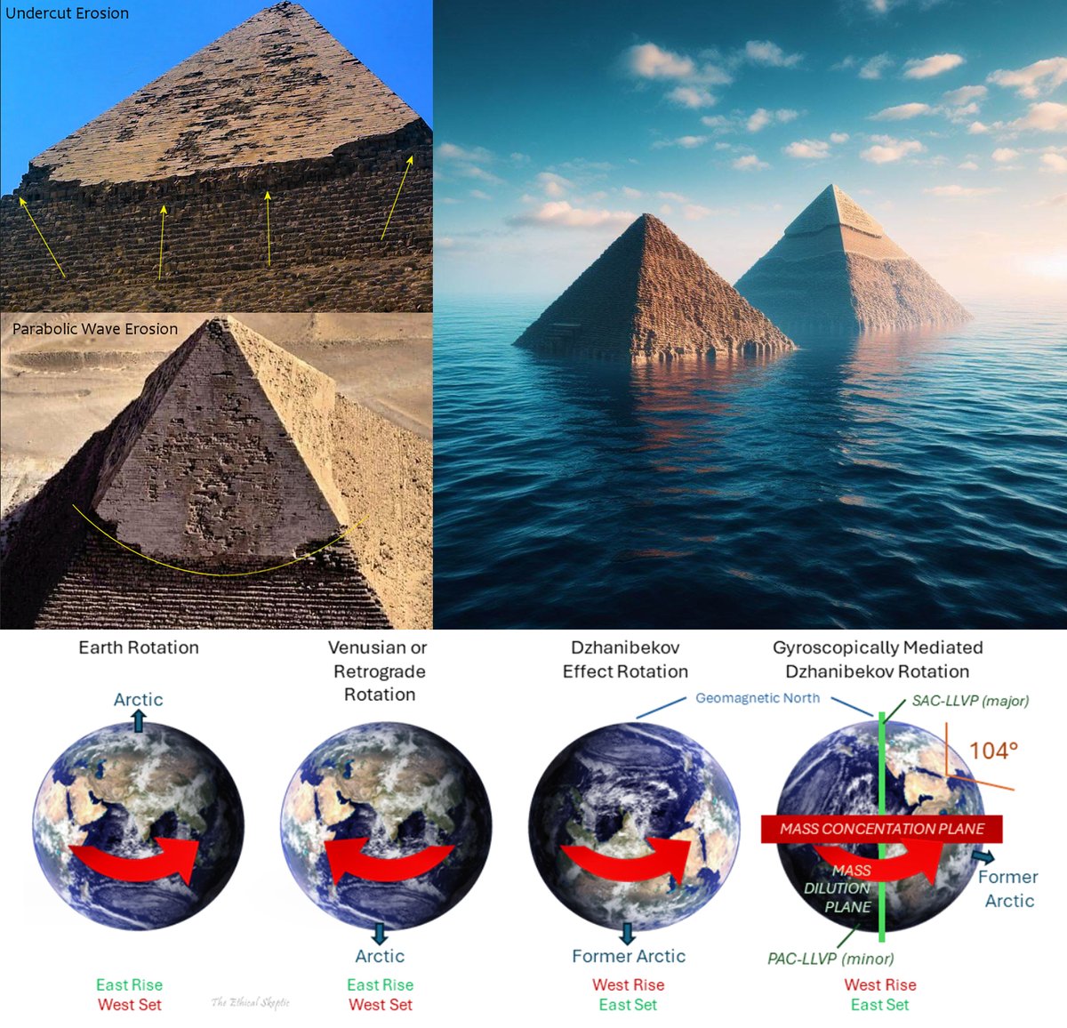
His main evidence, which left him stunned, came after he visited the pyramids in Giza and uncovered strong evidence of them being underwater. He suggests that the Tura limestone casing stones were damaged by water erosion, specifically by seawater, rather than being stolen or scavenged for reuse. The erosion patterns observed on the Tura limestone casing stones are consistent with the effects of seawater.
The Earth's core undergoes a weakening of its magnetic moment, reducing the magnetic coupling between the core and mantle. This weakening influences the position of the geographic North Pole.
The Earth’s core undergoes extreme exothermic changes, releasing kinetic energy. This heat then flows upwards to the asthenosphere (the semi-fluid layer beneath the Earth's crust) and into the depths of the ocean.
This is observed particularly in the South African Cusp, which is becoming less dense and more dynamic due to the influx of heat. Isn't this where the South Atlantic Magnetic Anomaly is spreading? Is this also connected to the anomaly of the black appearance on the Ventusky systems in the same area?
This additional heat contributes to the melting of Arctic and Antarctic polar ice sheets from the bottom up, especially in winter.
The ocean heats the atmosphere more efficiently than the atmosphere heats the ocean. This shift in heat dynamics disrupts the previous equilibrium, causing more pronounced warming effects.
This heat could also contribute to increased volcanic and seismic activity, as well as the appearance of wildfires earlier than expected, like the ones in Canada last year.
Because of the weakening of the core's magnetic field, over decades, Earth's rotation speeds up due to the loss in magnetic coupling between the outer core and the mantle.
The Earth's geomagnetic north pole has drifted significantly over the past few decades, with its rate of drift accelerating to an average speed of 55 kilometers (34 miles) per year. This wandering is accompanied by a pronounced weakening of the Earth's magnetic moment.
These mantle regions, especially the South Africa Cusp, could become less dense compared to the surrounding mantle, altering the Earth's mass distribution.
This change in mass distribution, combined with reduced geomagnetic coupling, could lead to a gyroscopically mediated reorientation of the Earth's rotational axis.
The hypothesis suggests a shift of the Earth's rotational axis by 104 degrees along the 31° East Meridian.
A shift of this magnitude would fundamentally alter the Earth's rotation, potentially changing the length of days and affecting the planet's overall stability leading to the floods of the ancient mtyhs.
He compares the Epic of Gilgamesh and the flood of Utanapishtim as more accurate descriptions of this cyclical phenomenon than the Biblical flood of Noah, which is a more simplified version.
This is his original theory, and I strongly recommend that you read his work, which I'll leave in the comments. It's different from Suspicious Observers', but these two theories don't cancel each other out; they can both occur, because Suspicious Observers' main theory is the Solar Micro Nova.
Like I said, his theory about the magnetic decoupling and the release of kinetic heat gave me a chilling feeling about the third secret of Fatima and this excerpt from her diary, written in her own handwriting:
"The tip of the spear, like a flame (kinetic heat), unlatches and touches the axis (gyroscope rotation) of the Earth. It shatters mountains, cities, towns, and villages, burying their inhabitants. The seas, rivers, and clouds burst from their limits, overflowing and engulfing houses and people in numbers too vast to count."
Also, Edgar Cayce the famous prophet, predicted the pole shift before the actual pole shift was even measured and confirmed. The first expedition to find the magnetic north, in 1831, pinpointed it in the Canadian Arctic. By the time the US Army went looking for the pole in the late 1940s, it had shifted 250 miles (400 kilometers) to the northwest. Cayce was aware of this through his trance-like prophecies in the early 1920s.
Cayce predicted that these major changes would begin between 1958 and 1998, reaching a point of no return. Ethical Skeptic's theory suggests that they began in 1973.
Let me know if you want more posts about this.
Last Seen Hashtags on Sotwe
Most Popular Users

Elon Musk 
@elonmusk
241.6M followers

Barack Obama
@barackobama
118.9M followers

Cristiano Ronaldo
@cristiano
114.6M followers

Donald J. Trump
@realdonaldtrump
111.8M followers

Narendra Modi
@narendramodi
107.1M followers

Rihanna
@rihanna
98.7M followers

NASA
@nasa
92.3M followers

Justin Bieber
@justinbieber
91.8M followers

KATY PERRY
@katyperry
90.1M followers

Taylor Swift
@taylorswift13
84M followers

Lady Gaga
@ladygaga
75.5M followers

Virat Kohli
@imvkohli
73.5M followers

Kim Kardashian
@kimkardashian
70.9M followers

YouTube
@youtube
68.8M followers

Neymar Jr
@neymarjr
66.5M followers

Bill Gates
@billgates
65.2M followers

Selena Gomez
@selenagomez
63.1M followers

The Ellen Show
@theellenshow
62.2M followers

CNN
@cnn
61.8M followers

X
@x
60.7M followers