Top Tweets for #MapViewer

Cape Town IS&T Department launches redesigned MapViewer
@CityofCT
#NewsInvasion24 #Africa #SouthAfrica #CapeTown #ISandTDepartment #MapViewer #Redesigned #CorporateServices #AldermanTheresaUys
https://t.co/YdEAoV2nYx

Novedades de @ArcGISOnline con Pilar Bravo: nueva consola de administración de créditos, animaciones en #MapViewer... ¡Y gaussiam splats soportadas en #3D, entre otras! 😍 #EsriTechDay 🌍 @Esri_Spain #ArcGIS


What’s New in Map Viewer: new tools for exploration, editing, and collaboration—plus the retirement of Map Viewer Classic. See what’s new! 📖 https://t.co/7XW4CVaE20 🗺 https://t.co/EDHuC7ZRGP #ArcGIS #MapViewer #WhatsNewWednesday #GISUpdates

🆕 Новата версия на #ArcGISOnline вече е налична.
Анимации в #MapViewer, по-прецизно изчертаване на криви, времева видимост на слоеве, нови #AI асистенти и още възможности за анализ и визуализация.
Вижте новостите ➡️ https://t.co/yl1FHoBt1q

Upgrade your mapping in #MapViewer! With this latest #ArcGISOnline release you can define visible time ranges, animate any vector symbol, draw and edit curved features, and more. Read the blog to learn about these new features. Read here ➡️ https://t.co/mZvD8Wj3fy

🗺️ Explore the new features in #MapViewer recently released in #ArcGISEnterprise 12.0! These new features will transform workflows to make data visualization faster and more intuitive.
Read to learn more ➡️ https://t.co/7HKyW8pGug


🗺️ Explore the new features in #MapViewer recently released in #ArcGISEnterprise 12.0! These new features will transform workflows to make data visualization faster and more intuitive.
Read to learn more ➡️ https://t.co/w26xBiWYXy


📣 Join our 45-min webinar Fri, 21 Nov! See how MetroMap aerial imagery helps SMBs plan smarter, make informed decisions & streamline workflows.
🎥 Demo of MapViewer + real-world examples.
👉 Register: https://t.co/8R4MA7lgni
#AerialImagery #SMB #MapViewer #BusinessInsights
We’re thrilled to introduce the latest evolution of our intuitive web-based mapping interface, MetroMap MapViewer!
Not a MetroMap user yet?
Start a Free Trial Today: https://t.co/2tcVsmBwZO
#MetroMap #MapViewer #AerialImagery #GIS #Geospatial #Innovation


🌐💻➡️ En esta entrada se va a mostrar cómo incluir imágenes en datos de tipo punto en un visor de 𝗔𝗿𝗰𝗚𝗜𝗦 𝗼𝗻𝗹𝗶𝗻𝗲.
Enlace: https://t.co/spc2ZHM3ib
#ArcGISOnline #mapviewer #ArcGIS

Join us for a free webinar this Thursday: Say Hello to AI Assistants in ArcGIS
AI is becoming a familiar part of the #ArcGIS system, offering new ways to support your everyday tasks. #Survey123 #Arcade #MapViewer @EsriUK
➡️Register now: https://t.co/zX3Ns5oE3F


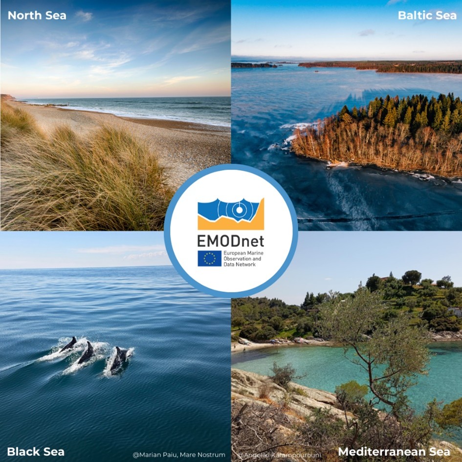
#DYK EMODnet offers #MarineData and #DataProducts for Europe's diverse regional sea-basins? 🌊 With the EMODnet #MapViewer you can browse, visualise and select the area(s) you need, or simply download the fully harmonised European scale maps!
Take your maps to the next level with #MapViewer! Join our sessions at #EsriUC2025 to learn how to create stunning, informative maps and enhance decision-making. Check out more details on Map Viewer and our sessions below 🗺️💫
Learn more ➡️ https://t.co/IuJqEsolBp


🚀𝗔𝗿𝗰𝗚𝗜𝗦 𝗢𝗻𝗹𝗶𝗻𝗲-𝘂𝗽𝗱𝗮𝘁𝗲 𝗷𝘂𝗻𝗶 𝟮𝟬𝟮𝟱 𝗯𝗲𝘀𝗰𝗵𝗶𝗸𝗯𝗮𝗮𝗿
De update brengt krachtige verbeteringen die uw ArcGIS-ervaring naar een hoger niveau tillen. Ontdek hier de nieuwste mogelijkheden: https://t.co/OFKsyOQX3z
#ArcGISOnline #MapViewer #release
🌐💻➡️ En esta entrada se va a mostrar cómo incluir imágenes en datos de tipo punto en un visor de 𝗔𝗿𝗰𝗚𝗜𝗦 𝗼𝗻𝗹𝗶𝗻𝗲.
Enlace: https://t.co/spc2ZHLvsD
#ArcGISOnline #mapviewer #ArcGIS
Разбрахте ли за всички полезни и вълнуващи новости, които вече са налични в Map Viewer, част от #ArcGISOnline?
От по-лесно редактиране и анимирани символи до подобрени маршрути и разширени анализи, сега #MapViewer е по-мощен и интуитивен от всякога 👉
https://t.co/WyGvcBkLqL
🌐💻➡️ En esta entrada se va a mostrar cómo incluir imágenes en datos de tipo punto en un visor de 𝗔𝗿𝗰𝗚𝗜𝗦 𝗼𝗻𝗹𝗶𝗻𝗲.
Enlace: https://t.co/spc2ZHLvsD
#ArcGISOnline #mapviewer #ArcGIS

Great news! #ModelBuilder (Beta) is now available in #MapViewer! Build #models that connect #analysistools and #data together. Read more about the update in the #ArcGIS blog post. Happy Modelling!
#GIS #ArcGISOnline #STEAM #GISSkills #mapping
https://t.co/Br6R9EeXSc

Check out the latest #ArcGISOnline updates! Including new #analysistools and #viewshed in #SceneViewer and #Modelbuilder in beta in #MapViewer! #ArcGIS #mapping #GIS #STEAM #K12
https://t.co/edeiVyHWgf

🌐💻➡️ En esta entrada se va a mostrar cómo incluir imágenes en datos de tipo punto en un visor de 𝗔𝗿𝗰𝗚𝗜𝗦 𝗼𝗻𝗹𝗶𝗻𝗲.
Enlace: https://t.co/baVMMWKyaR
#ArcGISOnline #mapviewer #ArcGIS
Last Seen Hashtags on Sotwe
Most Popular Users

Elon Musk 
@elonmusk
240.1M followers

Barack Obama
@barackobama
119.3M followers

Donald J. Trump
@realdonaldtrump
111.6M followers

Cristiano Ronaldo
@cristiano
108.8M followers

Narendra Modi
@narendramodi
106.9M followers

Rihanna
@rihanna
97.2M followers

NASA
@nasa
92.1M followers

Justin Bieber
@justinbieber
90.5M followers

KATY PERRY
@katyperry
86.7M followers

Taylor Swift
@taylorswift13
80.5M followers

Lady Gaga
@ladygaga
72.1M followers

Kim Kardashian
@kimkardashian
69.4M followers

YouTube
@youtube
68.6M followers

Virat Kohli
@imvkohli
68.4M followers

Bill Gates
@billgates
63.4M followers

The Ellen Show
@theellenshow
62.5M followers

CNN
@cnn
61.9M followers

Neymar Jr
@neymarjr
61M followers

X
@x
60.9M followers

CNN Breaking News
@cnnbrk
59.9M followers