Top Tweets for #Mapillary

Faster, Smarter, Better: Mapillary Uploader 5.1.1 is here! 💻
We’ve optimized the upload process to save power users critical time. Plus, enjoy enhanced camera compatibility with mapillary_tools v0.14.6 and bug fixes.
#Mapillary #GIS #Geospatial

🌍 Mapillary Blog: Giving AI a Sense of Place with @zephrxyz 📍
Using @mapillary imagery + @OvertureMaps data to cut POI position error by 67% and ground AI in a real sense of place.
Read here: https://t.co/MTlyuOJXWz
#SpatialAI #Mapillary #OvertureMaps

Putting my district on the map 🗺️
#mapillary

Abdul-Nayar Rabiatu will be presenting “Using Mobile Mapping Tools to Document and Improve Community Visibility in the Damongo District, Ghana." Her session will highlight how mobile mapping empowers...
#SotMAfrica2026 #SotMAfrica
Read more: https://t.co/VQ750GdHh3


For integrating Mapillary with Openlayers, check below blog.
https://t.co/Ko9NngqPvu
#Mapillary #GIS #OpenSource #Geospatial
Introducing the Mapillary API Demo! 🌐
An interactive web app to test our API’s capabilities. Source code included.
Blog: https://t.co/stAdLw0arv
GitHub: https://t.co/8pQug07XMj
#Mapillary #GIS #OpenSource #Geospatial

Introducing the Mapillary API Demo! 🌐
An interactive web app to test our API’s capabilities. Source code included.
Blog: https://t.co/stAdLw0arv
GitHub: https://t.co/8pQug07XMj
#Mapillary #GIS #OpenSource #Geospatial
Mapillary Update - MUTCD Codes are Live on the Mapillary API
We're excited to share that you can now extract traffic sign data from Mapillary’s street-level imagery using official MUTCD through our API.
Get started : https://t.co/K3Soxlv3Cg
#Mapillary #GIS #DOT #MUTCD


Milestone: Four million 360-degree #StreetView images created and published under a license suitable for #OpenStreetMap purposes.
https://t.co/4WhKKiaCT0 #AT #DE #CH #Mapillary #GSV #DJI #OSMO360
Meilenstein, vier Millionen 360 Grad #StreetView Aufnahmen erstellt und in einer für #OpenStreetMap Zwecke geeigneter Lizenz publiziert.
https://t.co/4WhKKiaCT0 #AT #DE #CH #Mapillary #GSV #DJI #OSMO360

📢🌴🌴📌🗺️ Dos nuevos registros #Jubaea chilensis (Palma chilena) en #OpenStreetMap natural=tree, en total 5450. Juvenil en Laffrey-Francia 🇫🇷 y adulta en #Santiago 🇨🇱. El visor de @MapComplete integra las imágenes #Mapillary (360°) y #Panoramax #AUPV https://t.co/dnoT9gxtwy


#Meta:
- #Zuckerberg
- #Facebook
- #Instagram
- #WhatsApp
- #Mapillary
- #MetaQuest
- #Threads
@CNIL

🔴 Un ex-employé de Meta est accusé d’avoir téléchargé 30 000 photos privées Facebook en contournant la sécurité interne. Une affaire explosive qui relance la peur d’un espionnage massif.
https://t.co/nLoS5v8ZgP

Reposted from prithvignya.jntuh Instagram:
Our inaugural event PRITHVIGNYA was successfully completed.
Heartfelt thanks to Mr. Pawan Muddu and #UNMappers for their support and inspiration.
#UNMaps #UNMappers #openstreetmap #everydoor #mapillary #techfest #jntuh #mapping #gis
🌍 Mapillary March: Top Mappers 🏅
Congrats to this month's top contributors!
From veterans to newcomers, your imagery supports maps around the world.
Amazing work to our community!
Happy Mapping! 📸
#GIS #Mapillary #Geospatial #OSM #Maps


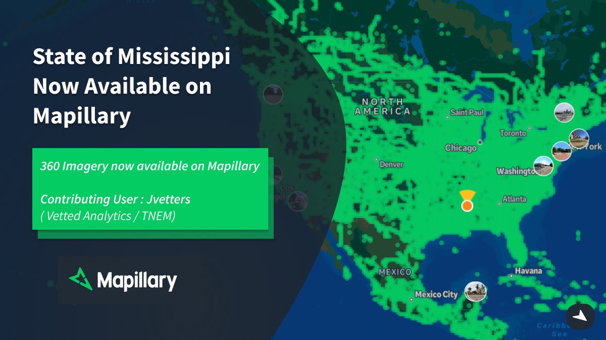
1.5M images. 4 vehicles. 1 mission. 🛣️
Check out our latest Spotlight: Josh Vetters & Vetted Analytics - @mapillary + @GoPro to secure FEMA funding for MS & TN DOTs.
Providing a "driver’s eye view" for disaster recovery.
Watch: https://t.co/s4H7dui0gc
#GIS #Mapillary #FEMA
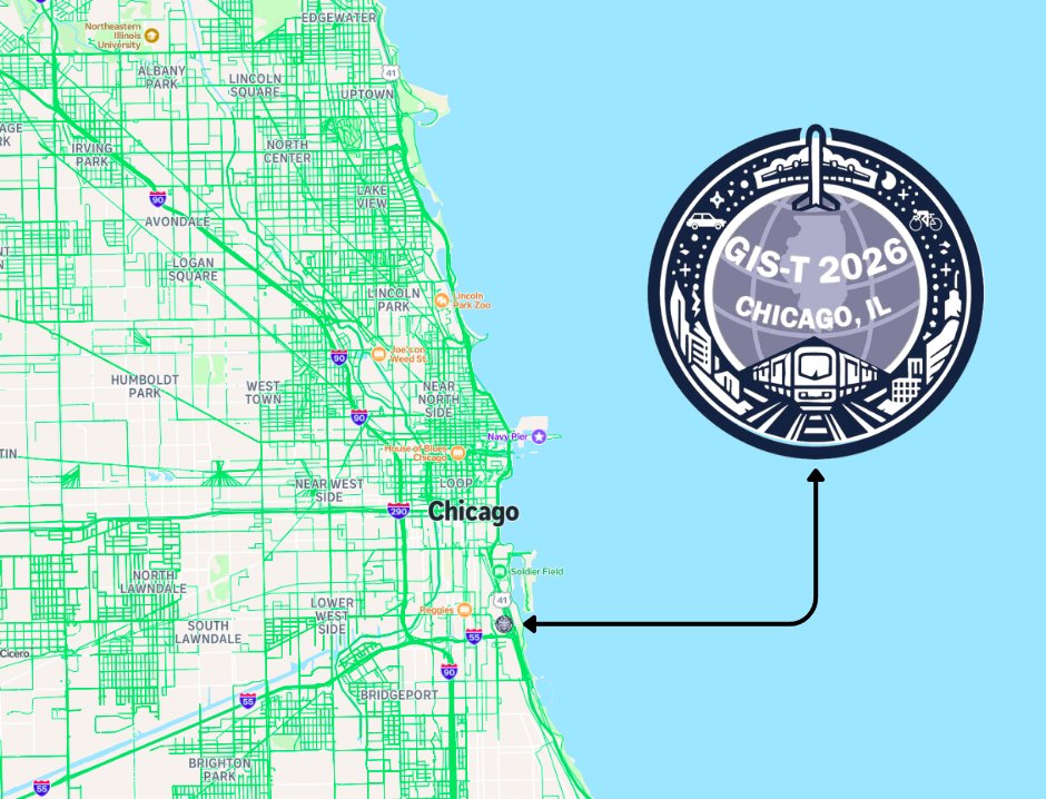
Next stop: Chicago!
The Mapillary team is headed to #GIST2026.
We’re ready to talk all things street-level imagery and transport innovation. Stop by our booth to see how we’re scaling GIS workflows with the community.
See you there! 🌎
#GIST2026 #Mapillary #GIS #Chicago

@KyleClark @MarcSallinger @nexton9news Wondering if crowdsourced #OpenStreetMap users promptly updating Denver 13th/14th street changes in #OSM data, maybe even with street-level images (e.g. #Mapillary, #Mapilio, #KartaView) for ground truth. Many apps, services use OSM ecosystem for maps, routing
Get the Street Level View : Capture with Mapillary 🌍
While Satellite data sets the stage, for ground-truth data, you need immersive high-resolution street level imagery.
Get started with Mapillary : https://t.co/RVHwXMDBTg
#Mapillary #GIS #Transportation #Surveying

Mapillary is coming to #FedGIS2026 🌎
Come and say hello to the team in Washington DC at the largest event for federal GIS professionals!!
If you’re attending and want to discuss all things Mapillary, reach out!
#Mapillary #GIS #GEOINT #AI #FederalIT


Last Seen Hashtags on Sotwe
Trends for you
Most Popular Users

Elon Musk 
@elonmusk
240.1M followers

Barack Obama
@barackobama
119.3M followers

Donald J. Trump
@realdonaldtrump
111.6M followers

Cristiano Ronaldo
@cristiano
108.8M followers

Narendra Modi
@narendramodi
106.9M followers

Rihanna
@rihanna
97.2M followers

NASA
@nasa
92.1M followers

Justin Bieber
@justinbieber
90.5M followers

KATY PERRY
@katyperry
86.7M followers

Taylor Swift
@taylorswift13
80.5M followers

Lady Gaga
@ladygaga
72.1M followers

Kim Kardashian
@kimkardashian
69.3M followers

YouTube
@youtube
68.6M followers

Virat Kohli
@imvkohli
68.4M followers

Bill Gates
@billgates
63.4M followers

The Ellen Show
@theellenshow
62.5M followers

CNN
@cnn
61.9M followers

Neymar Jr
@neymarjr
61M followers

X
@x
60.9M followers

CNN Breaking News
@cnnbrk
59.9M followers