Top Tweets for #MapsandMapping

Day 16 of the #30DayMapChallenge - Minimal. All roads lead to Rome. This map is visualises the famous roads built by the Roman empire. I never get bored of looking at this map!
#Python #Data #DataScience #Geopython #mapsandmapping #Rome #DataVisualization #EU


Todos los caminos llevan a Roma. Este mapa visualiza las famosas carreteras construidas por el imperio romano. ¡Nunca me aburro de mirar este mapa!
#Python #Datos #DataScience #Geopython #mapsandmapping #Roma #DataVisualization #EU @PythonMaps
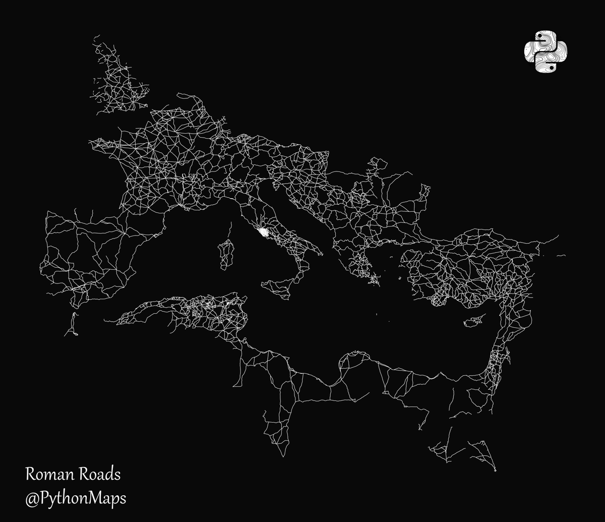
All roads lead to Rome. This map is visualises the famous roads built by the Roman empire. I never get bored of looking at this map!
#Python #Data #DataScience #Geopython #mapsandmapping #Rome #DataVisualization #EU

All roads lead to Rome. This map is visualises the famous roads built by the Roman empire. I have removed the land to highlight how far this empire spread its infrastructure.
#Python #Data #DataScience #Geopython #mapsandmapping #Rome #DataVisualization #EU

All roads lead to Rome. This map is visualises the famous roads built by the Roman empire. Day 24 of the #30DayMapChallenge - Historical
#Python #Data #DataScience #Geopython #mapsandmapping #Rome #DataVisualization #EU


We end the Surveying of Empire panel in Ireland, with a discussion of the Bodley maps of Ulster from @CatSPorter. They are fascinating in terms of what little we know of the survey & how beautiful they are (& full of things to study!) @seaa1718 #mapsandmapping @HakluytSociety

Baijayanti Chatterjee spoke of misconceptions of Indian cartography in the pre-colonial and colonial eras. Unsurprisingly, the imperial gaze has affected how we understand the history of and Indian contribution to #mapsandmapping in British India. @seaa1718 @HakluytSociety
Relieved to be done with my plenary for @seaa1718 #mapsandmapping.
Inspired by the stirring discussion that followed.
Mortified that 'Duke of York' somehow came out as 'dork'. #oops
@HakluytSociety
More discussion of indigenous knowledge and #mapsandmapping, this time in the context of the Great Lakes borderlands from @MikeBorsk. Builds on previous papers for larger argument about the elision of indigenous contributions and perspectives.
@seaa1718 @HakluytSociety
A stirring call for decolonization of American history and history of #mapsandmapping from Kristopher Ray (@HistoryatHull ) using intriguing examples of indigenous mapping. Great start to panel on Surveyors of Empire @seaa1718 @HakluytSociety
All roads lead to Rome. This map is visualises the famous roads built by the Roman empire. I have removed the land to highlight how far this empire spread its infrastructure.
#Python #Data #DataScience #Geopython #mapsandmapping #Rome #DataVisualization #EU

Got out the popcorn for this one! @maxedelson on imagining the interior of southeastern North America, 1500-1725–the keynote to finish the day of @seaa1718 #mapsandmapping @HakluytSociety

. @SilkDamask will close out this session on maps and narratives with a focus on maps of Boston made by the young ladies of Mrs. Rowson’s Academy. Love to see some mapping samplers and embroidered globes! @seaa1718 #mapsandmapping @HakluytSociety
No PowerPoint needed! Bertie Mandelblatt using the document viewer @JCBLibrary to discuss social lives of Adlum’s 1792 Pennsylvania Map, a recent acquisition for the JCB. #libraries #likeaboss @seaa1718 #mapsandmapping @HakluytSociety
The afternoon has started with #mapmonsters from Manon Turban and Herman Moll maps from Alex Zukas. They both discuss the narrative quality of maps. @seaa1718 #mapsandmapping @HakluytSociety
Just chaired wonderful panel on circulation & production of #maps. Papers on military mapping, pilot guides & protection strategies before copyright. Thanks @MiyamotoBen, Djoeke Van Netten, & @ijalexander2002 (in the middle of the night!) @seaa1718 @HakluytSociety #mapsandmapping

Great start to the #MapsandMapping conference today @HakluytSociety kicked off by @fairban_c Louise McCarthy, Julien Negre and @ameliederome
Some sweet #Photoshop to show us where Gulliver’s fanciful lands were located from Amelie Derome, who is examining the maps (and their censorship) in the French translation of #GulliversTravels. @seaa1718 #mapsandmapping @HakluytSociety
Julien Negre explains how the folding map of the Virginia-Carolina dividing line became “hairy” when read with William Byrd’s text. Maps can have texture! @seaa1718 #mapsandmapping @HakluytSociety
Continuing a discussion of maps in texts (and texts in maps) with Ladan Niayesh and Louise McCarthy on maps and masques as propaganda for the Virginia Company @seaa1718 #mapsandmapping @HakluytSociety
Trends for you
Most Popular Users

Elon Musk 
@elonmusk
240.6M followers

Barack Obama
@barackobama
119.3M followers

Donald J. Trump
@realdonaldtrump
111.7M followers

Cristiano Ronaldo
@cristiano
110.4M followers

Narendra Modi
@narendramodi
107M followers

Rihanna
@rihanna
97.6M followers

NASA
@nasa
92.2M followers

Justin Bieber
@justinbieber
90.9M followers

KATY PERRY
@katyperry
87.6M followers

Taylor Swift
@taylorswift13
81.4M followers

Lady Gaga
@ladygaga
72.9M followers

Kim Kardashian
@kimkardashian
69.7M followers

Virat Kohli
@imvkohli
69.7M followers

YouTube
@youtube
68.7M followers

Bill Gates
@billgates
63.8M followers

The Ellen Show
@theellenshow
62.5M followers

Neymar Jr
@neymarjr
62.5M followers

CNN
@cnn
61.9M followers

X
@x
60.8M followers

Selena Gomez
@selenagomez
60.6M followers