Top Tweets for #mapsandmapping

Day 16 of the #30DayMapChallenge - Minimal. All roads lead to Rome. This map is visualises the famous roads built by the Roman empire. I never get bored of looking at this map!
#Python #Data #DataScience #Geopython #mapsandmapping #Rome #DataVisualization #EU


Todos los caminos llevan a Roma. Este mapa visualiza las famosas carreteras construidas por el imperio romano. ¡Nunca me aburro de mirar este mapa!
#Python #Datos #DataScience #Geopython #mapsandmapping #Roma #DataVisualization #EU @PythonMaps
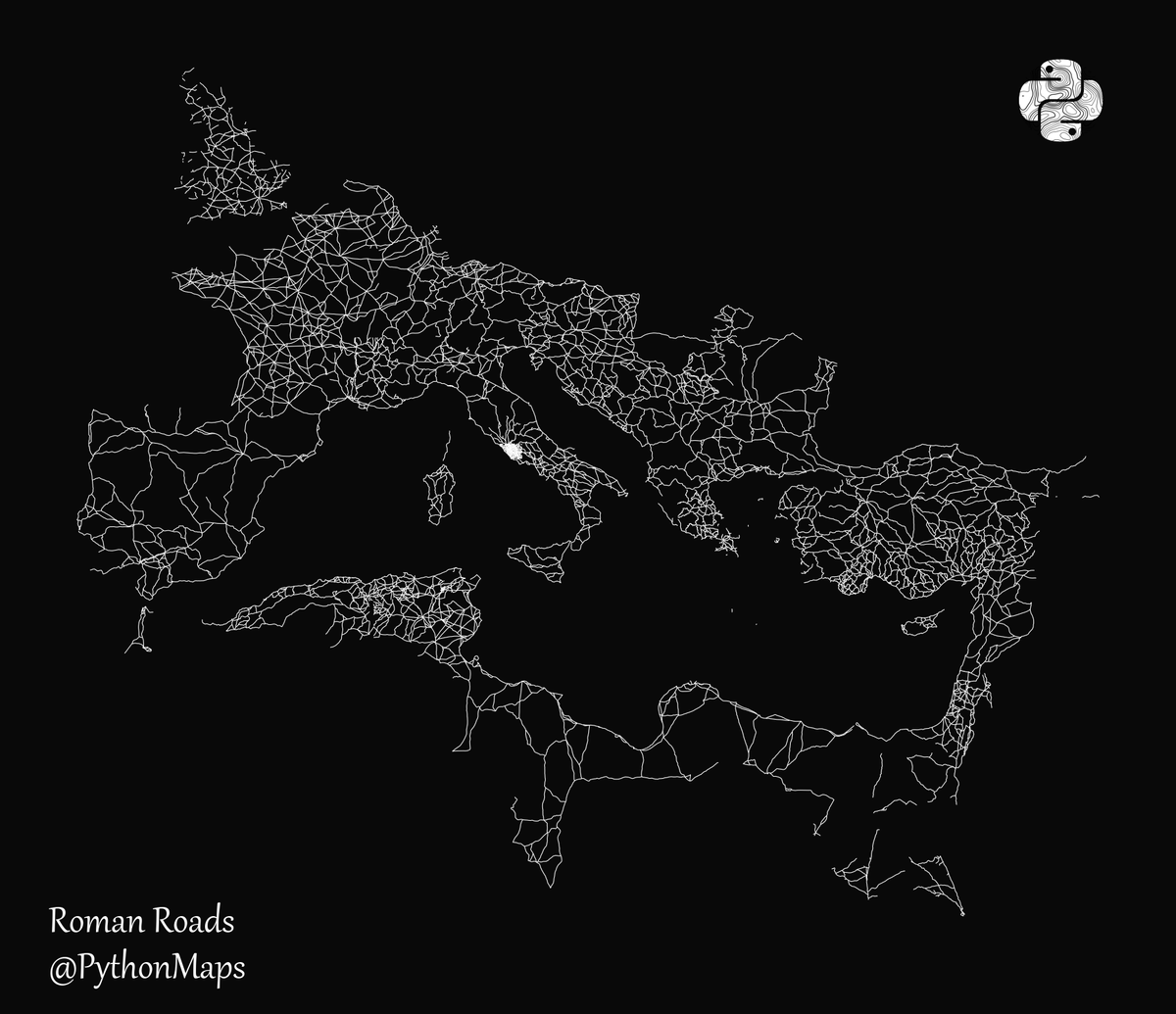
All roads lead to Rome. This map is visualises the famous roads built by the Roman empire. I never get bored of looking at this map!
#Python #Data #DataScience #Geopython #mapsandmapping #Rome #DataVisualization #EU

All roads lead to Rome. This map is visualises the famous roads built by the Roman empire. I have removed the land to highlight how far this empire spread its infrastructure.
#Python #Data #DataScience #Geopython #mapsandmapping #Rome #DataVisualization #EU

All roads lead to Rome. This map is visualises the famous roads built by the Roman empire. Day 24 of the #30DayMapChallenge - Historical
#Python #Data #DataScience #Geopython #mapsandmapping #Rome #DataVisualization #EU


We end the Surveying of Empire panel in Ireland, with a discussion of the Bodley maps of Ulster from @CatSPorter. They are fascinating in terms of what little we know of the survey & how beautiful they are (& full of things to study!) @seaa1718 #mapsandmapping @HakluytSociety

Baijayanti Chatterjee spoke of misconceptions of Indian cartography in the pre-colonial and colonial eras. Unsurprisingly, the imperial gaze has affected how we understand the history of and Indian contribution to #mapsandmapping in British India. @seaa1718 @HakluytSociety
Relieved to be done with my plenary for @seaa1718 #mapsandmapping.
Inspired by the stirring discussion that followed.
Mortified that 'Duke of York' somehow came out as 'dork'. #oops
@HakluytSociety
More discussion of indigenous knowledge and #mapsandmapping, this time in the context of the Great Lakes borderlands from @MikeBorsk. Builds on previous papers for larger argument about the elision of indigenous contributions and perspectives.
@seaa1718 @HakluytSociety
A stirring call for decolonization of American history and history of #mapsandmapping from Kristopher Ray (@HistoryatHull ) using intriguing examples of indigenous mapping. Great start to panel on Surveyors of Empire @seaa1718 @HakluytSociety
All roads lead to Rome. This map is visualises the famous roads built by the Roman empire. I have removed the land to highlight how far this empire spread its infrastructure.
#Python #Data #DataScience #Geopython #mapsandmapping #Rome #DataVisualization #EU

Got out the popcorn for this one! @maxedelson on imagining the interior of southeastern North America, 1500-1725–the keynote to finish the day of @seaa1718 #mapsandmapping @HakluytSociety

. @SilkDamask will close out this session on maps and narratives with a focus on maps of Boston made by the young ladies of Mrs. Rowson’s Academy. Love to see some mapping samplers and embroidered globes! @seaa1718 #mapsandmapping @HakluytSociety
No PowerPoint needed! Bertie Mandelblatt using the document viewer @JCBLibrary to discuss social lives of Adlum’s 1792 Pennsylvania Map, a recent acquisition for the JCB. #libraries #likeaboss @seaa1718 #mapsandmapping @HakluytSociety
The afternoon has started with #mapmonsters from Manon Turban and Herman Moll maps from Alex Zukas. They both discuss the narrative quality of maps. @seaa1718 #mapsandmapping @HakluytSociety
Just chaired wonderful panel on circulation & production of #maps. Papers on military mapping, pilot guides & protection strategies before copyright. Thanks @MiyamotoBen, Djoeke Van Netten, & @ijalexander2002 (in the middle of the night!) @seaa1718 @HakluytSociety #mapsandmapping

Great start to the #MapsandMapping conference today @HakluytSociety kicked off by @fairban_c Louise McCarthy, Julien Negre and @ameliederome
Some sweet #Photoshop to show us where Gulliver’s fanciful lands were located from Amelie Derome, who is examining the maps (and their censorship) in the French translation of #GulliversTravels. @seaa1718 #mapsandmapping @HakluytSociety
Julien Negre explains how the folding map of the Virginia-Carolina dividing line became “hairy” when read with William Byrd’s text. Maps can have texture! @seaa1718 #mapsandmapping @HakluytSociety
Continuing a discussion of maps in texts (and texts in maps) with Ladan Niayesh and Louise McCarthy on maps and masques as propaganda for the Virginia Company @seaa1718 #mapsandmapping @HakluytSociety
Last Seen Hashtags on Sotwe
beautiful
Seen from United States
ChapinasDeCorte
Seen from Guatemala
cntr
Seen from Korea
MizuMikazuki
Seen from United Kingdom
エスパー・小林
Seen from Japan
alanyashemale
Seen from Turkey
ชายแท้กาฬสินธุ์
Seen from Thailand
bnwo #pmv
Seen from Spain
novinha boquete
Seen from Netherlands
besthandjob
Seen from Turkey
Trends for you
Most Popular Users

Elon Musk 
@elonmusk
240.6M followers

Barack Obama
@barackobama
119.3M followers

Donald J. Trump
@realdonaldtrump
111.7M followers

Cristiano Ronaldo
@cristiano
110.4M followers

Narendra Modi
@narendramodi
107M followers

Rihanna
@rihanna
97.6M followers

NASA
@nasa
92.2M followers

Justin Bieber
@justinbieber
90.9M followers

KATY PERRY
@katyperry
87.6M followers

Taylor Swift
@taylorswift13
81.4M followers

Lady Gaga
@ladygaga
72.9M followers

Kim Kardashian
@kimkardashian
69.7M followers

Virat Kohli
@imvkohli
69.7M followers

YouTube
@youtube
68.7M followers

Bill Gates
@billgates
63.8M followers

The Ellen Show
@theellenshow
62.5M followers

Neymar Jr
@neymarjr
62.4M followers

CNN
@cnn
61.9M followers

X
@x
60.8M followers

Selena Gomez
@selenagomez
60.6M followers