Top Tweets for #MasterMap

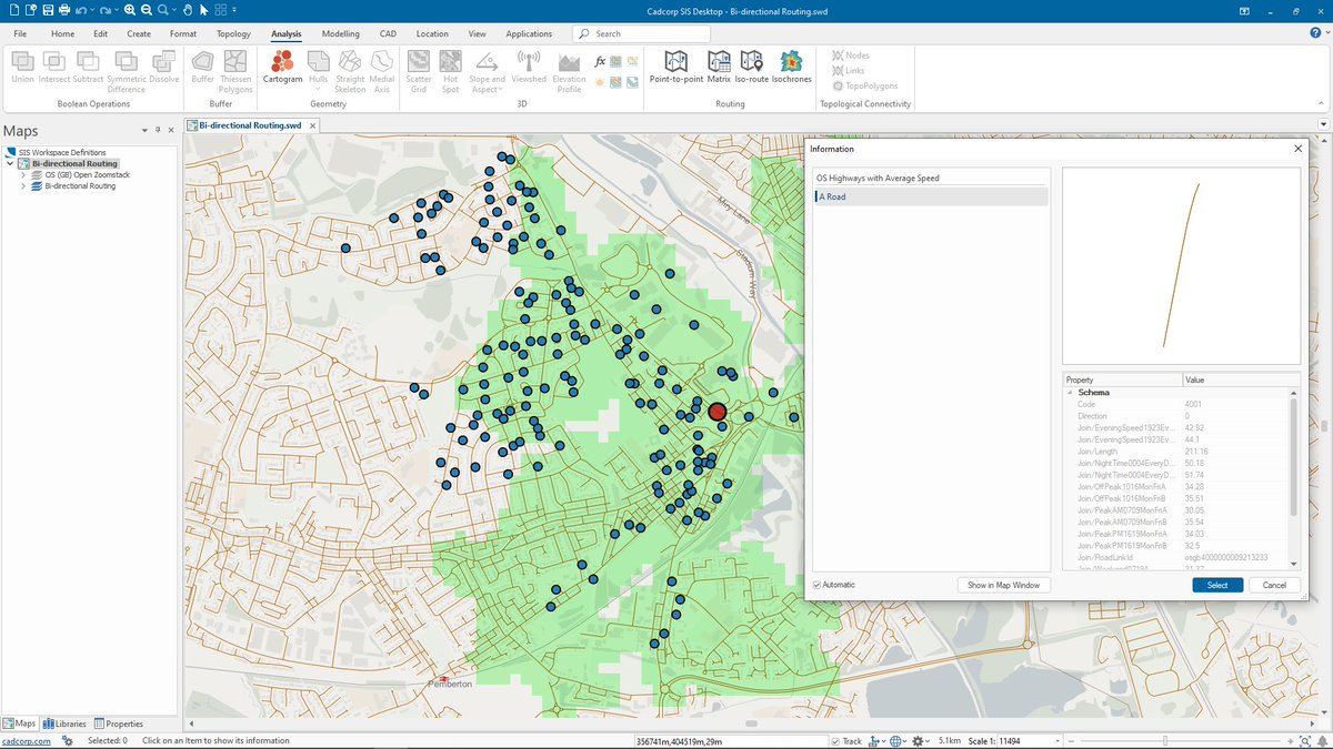
Cadcorp SIS 9.1 is here | #SISDesktop free route-finding tools now include bi-directional route costs and can be used with @ordnancesurvey #MasterMap Highways Network with speed data. What else is new? https://t.co/04Fscd5UCe #SIS9.1 #MakingSenseofPlace #spatialinsight #GIS

Thought I'd try moving my @OrdnanceSurvey #Mastermap upload to @PostGIS processes to @SafeSoftware....but it doesn't like the feature collection format of the changehistory field.
Surely there are #FME models for this somewhere?
Any ideas #gischat?
#gis #geo #geoautomation

We provide a vast range of digital mapping services. We work with a network of suppliers, including Ordnance Survey, to ensure we can offer a choice of content and formats: https://t.co/bKg6byc7mw
#digitalmapping #mappingservices #ordnancesurvey #mastermap #addressdata


🇪🇺 #MyEUSpace : +200 ideas submitted | 43 selected | 11 winner🏆 3 🇫🇷 awarded 👍 #MasterMap a solution of road status #SaNGENE an integrated GNSS-based radar for detection of obstacles #EO4ART an application for artistic products @France_CZ @EU4Space

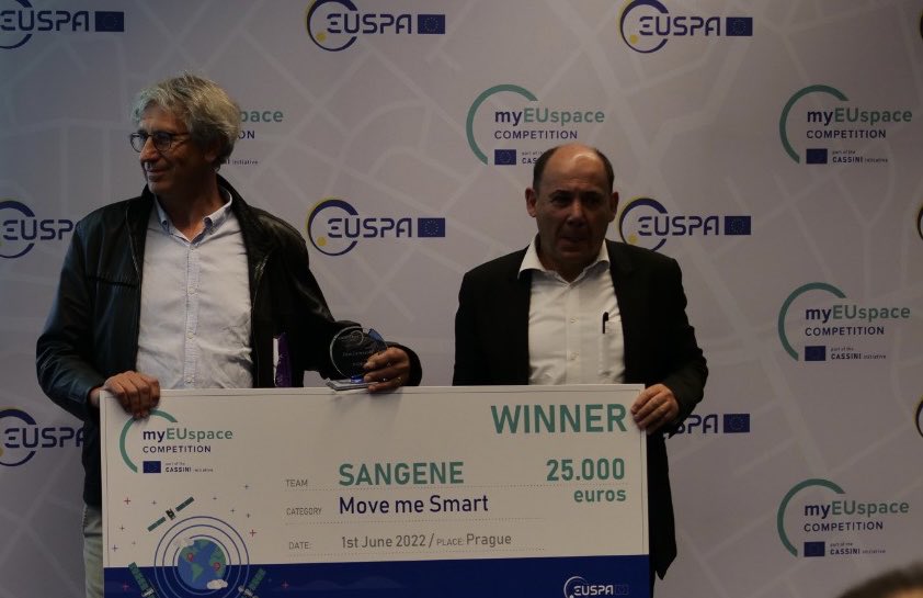


#MasterMap, a solution for automatic mapping of road status for maintenance optimization, is the winner of the "Surveying Solutions to shape the future of geomatics" area from #myEUspace Track 1!
Well done, congratulations!


Next week is going to be huge!! 🎮 Who's ready for the very 1st @Mastermind_MGT medium article release?! On top of that, the #MasterPlan could be out any moment! 😍 Oh, and I hear there's a #MasterMap and it leads to #TReaSuRe!!🏴☠️
@BubbleTea1110 @loopeyRV

When purchasing @OrdnanceSurvey MasterMap from emapsite, you have the flexibility to download multiple formats for use in different software at no additional cost
https://t.co/efRluHyeIM
#dwg #shp #cad #gis #mastermap #detailedmapping #planning #analysis

Did you know that you can view @OrdnanceSurvey MasterMap on our website for FREE? We don't charge our clients viewing fees, saving you time & money by ensuring you can select the exact data you need! https://t.co/iBG4bmBMto
#data #cad #gis #dataviz #mapping #location #mastermap


@OrdnanceSurvey launches OS #DataHub platform. Named the #OSDataHub, it will give users free access, up to a threshold, to #OS #MasterMap #data with access via multiple free #APIs via @UKAuthority #geospatial #mapping https://t.co/WqCAqtXuv7

We have integrated the new @OrdnanceSurvey Open Identifiers with our data! You can find out more in our June #newsletter - https://t.co/GS9YnciYru
Image below shows OS #MasterMap buildings coloured by building AGE.
#News #OpenData #UKBuildings #UKMap


Explore our wide range of #maps and use the ones most suitable to your project. Edozo can provide all the #mapping solutions you’ll need including #MasterMap, #City, #Street, #Town and #Aerial.
Find out more https://t.co/XtmjEGP3Ne
#commercialproperty #realestate #OSmaps


The full GB pavement width data service in @ArcGISOnline derived from @OrdnanceSurvey #mastermap is available to any PSGA customer and now also under the OS Mapping for emergencies program to any organisation responding to the #covid19 crisis in the UK https://t.co/yWuwTH9m1x

A great Media Map feature in the @guardian, looking at pavement widths and how local authorities can help prepare for social distancing https://t.co/nYxNb1X1UG


Interested in serving @OrdnanceSurvey #MasterMap in @GeoserverO ? Our team is preparing a read-to-use data dir plus other instructions which we will release shortly for free. Stay tuned!
@OSGeo @foss4g @planetosgeo #geoserver @GeoNode @mapstore2 @foss4guk #sld #mapping #maps
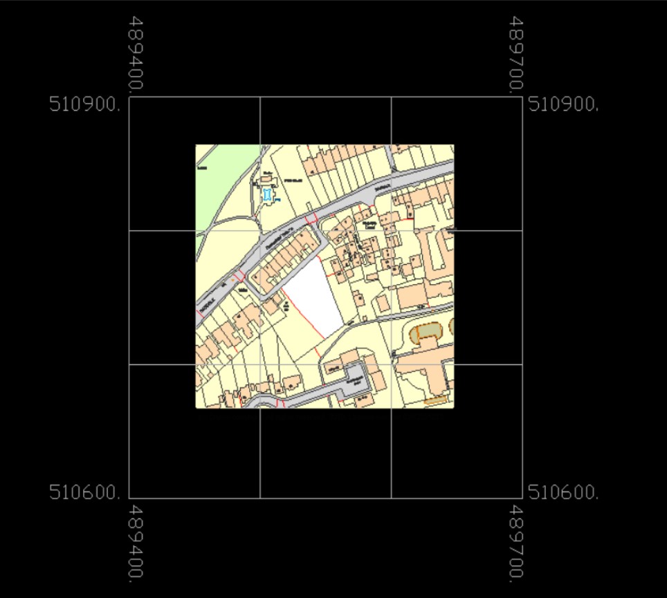
Have you tried our @OrdnanceSurvey MasterMap in DWG format plus Grid? The 100m grid gives a quick visual guide to location and scale when using Mastermap in CAD
Click here for more info and samples: https://t.co/x91bGtpV8L
#CAD #MasterMap #DataViz
With a full range of maps including #MasterMap, City, Street, Town and Aerial Edozo can provide all the #mapping solutions you’ll need.
#FridayQuiz - Can you guess where this is? Image shown is @OrdnanceSurvey #MasterMap in DWG format with Building Heights! #CAD #Location #FridayFeeling
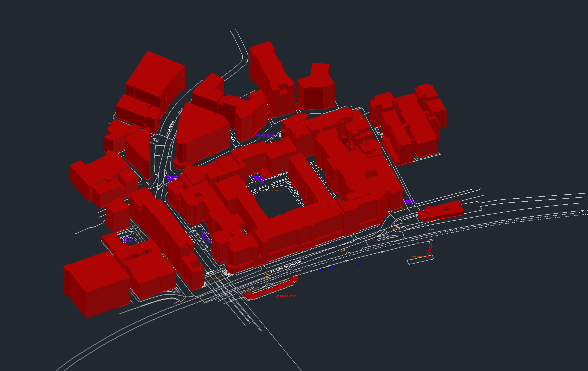
#FridayQuiz - Can you guess where this is? Image shown is @OrdnanceSurvey MasterMap in DWG Standard, including Building Heights #CAD #FridayFeeling #MasterMap


@OrdnanceSurvey on the stage talking #Maps and #MasterMap at the #RoSFutureFocus event in #Inverness. @RegistersOfScot

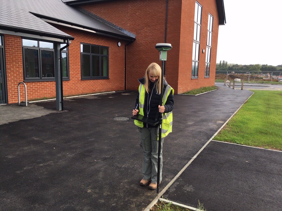
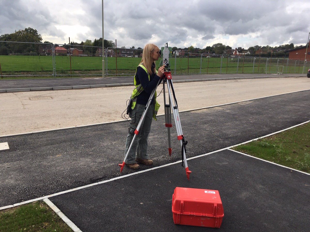
Brilliant day out with an @OrdnanceSurvey surveyor. Got to see the detailed work that goes into making our data and maps so detailed and trusted! Proud to contribute to #MasterMap
#FridayQuiz - Can you name this castle? Shown below on
@OrdnanceSurvey
#MasterMap #Imagery? To find out more about the Aerial Imagery we provide, please visit our website: https://t.co/gVEwZOVlOw #FridayFun #FridayFeeling #aerialphotography #CAD #GIS

Last Seen Hashtags on Sotwe
313links
Seen from United States
bimbo
Seen from United Kingdom
E2eLogisticsSolutions
Seen from India
นัดเย็ดนครนายก
Seen from Thailand
bimbolife
Seen from United States
DignidadDanza
Seen from Indonesia
อวดเมีย
Seen from Thailand
NTR #네토
Seen from Korea
RoseWednesday
Seen from Brazil
Bjputtarraigad
Seen from Germany
Most Popular Users

Elon Musk 
@elonmusk
240.1M followers

Barack Obama
@barackobama
119.3M followers

Donald J. Trump
@realdonaldtrump
111.6M followers

Cristiano Ronaldo
@cristiano
108.9M followers

Narendra Modi
@narendramodi
107M followers

Rihanna
@rihanna
97.3M followers

NASA
@nasa
92.1M followers

Justin Bieber
@justinbieber
90.6M followers

KATY PERRY
@katyperry
86.8M followers

Taylor Swift
@taylorswift13
80.6M followers

Lady Gaga
@ladygaga
72.2M followers

Kim Kardashian
@kimkardashian
69.4M followers

YouTube
@youtube
68.6M followers

Virat Kohli
@imvkohli
68.5M followers

Bill Gates
@billgates
63.4M followers

The Ellen Show
@theellenshow
62.5M followers

CNN
@cnn
61.9M followers

Neymar Jr
@neymarjr
61.1M followers

X
@x
60.9M followers

Selena Gomez
@selenagomez
59.9M followers