

Top Tweets for #NegativeIOD

SST Climate Driver Update 🌊
The strongest #NegativeIOD event in recorded history, has now come to an end with the latest Index now standing at +0.09°C which is 'Neutral'. It will take another 30-40 days for the atmosphere to respond and decouple.
Meanwhile, weak #LaNina continues in the central #Pacific with the value of - 0.91°C.
What this means for us, is that after the snow drought in first half of #Winter2025-26, we will now start seeing an increased frequency of #WesternDisturbances affecting north India January into February, but since La Nina persists, these will still mostly be of moderate intensity, with the odd intense WD. Low latitude /south dipping WDs are now more likely especially heading into Feb.
#ColdWave conditions will grip large parts of central, north & west Bharat from mid Jan onwards, interrupted briefly by passing WDs. Feb however, may be warmer than average as WD frequency increases.
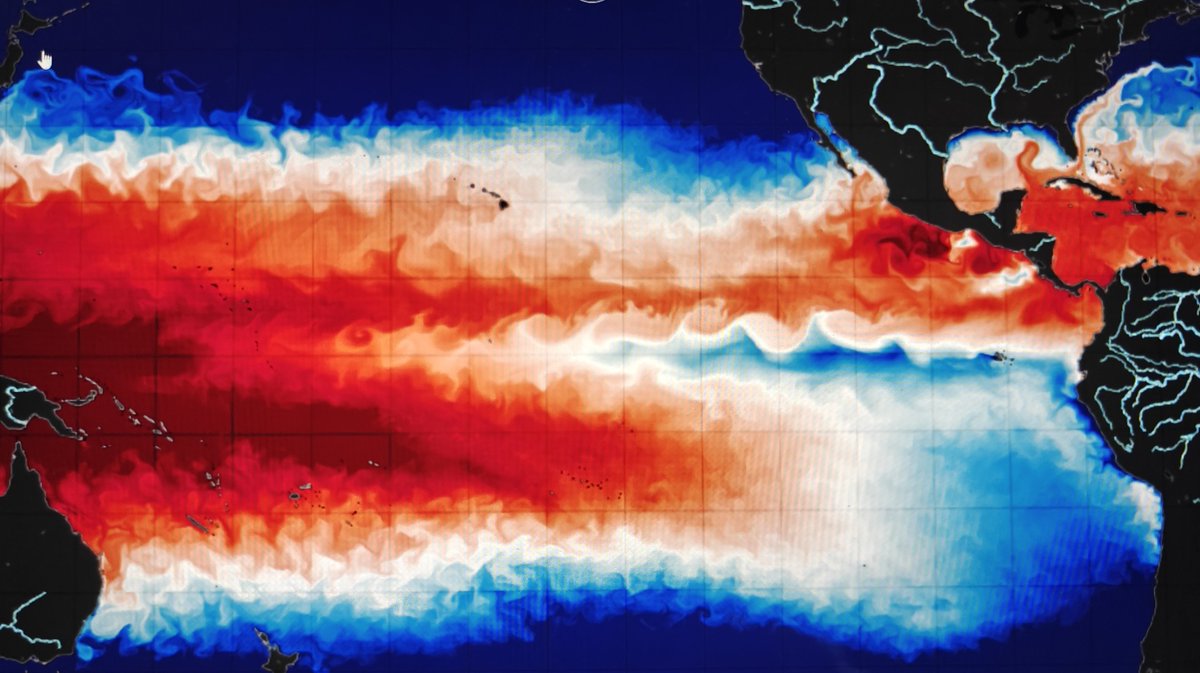
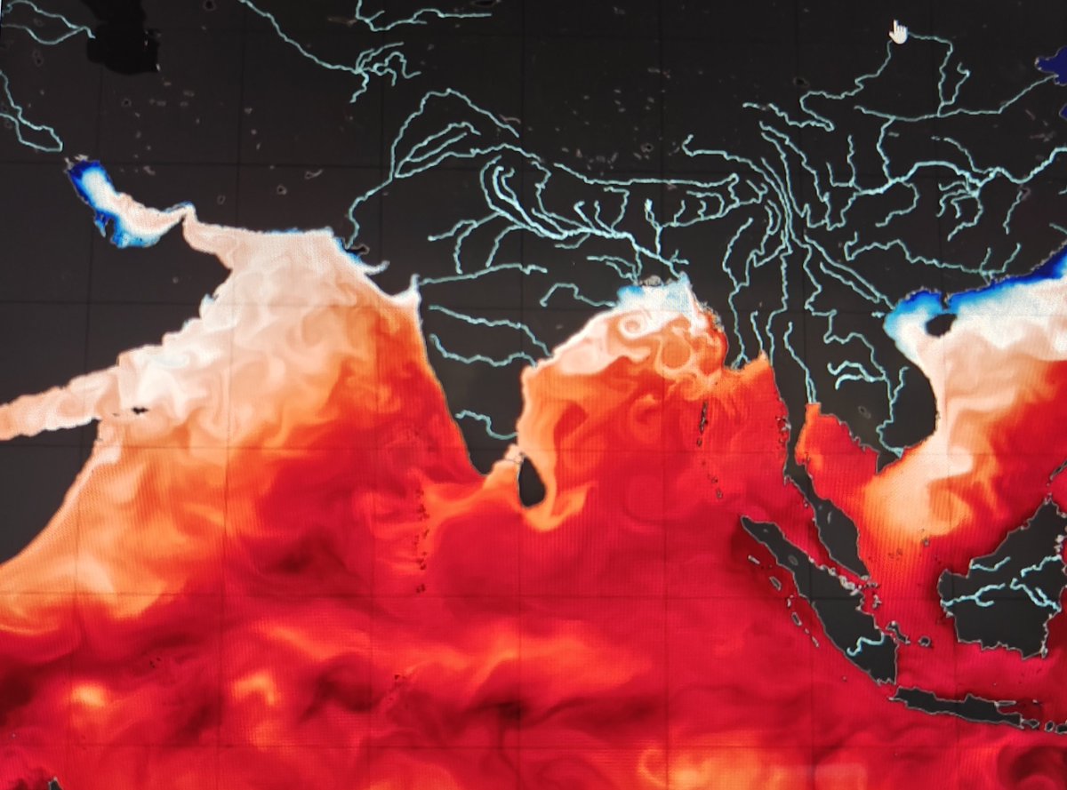
Why did #Mumbai see an early arrival of #Winter this season and the coldest November in the last 12 years?
I decode the role of global climate drivers on our winters in Navbharat Times
Many thanks to @SurajNBT for quoting
#LaNina #NegativeIOD

Strongest #NegativeIOD ON RECORD and #LaNina NOW UNDERWAY📉🌊 Watch evolution below!
On expected lines, ongoing -ve IOD event has peaked, reaching a value of -1.94°C, obliterating the negative IOD of 2022, emerging as the strongest event in recorded history!
Relative Nino 3.4 Index has been consistently at or below the La Nina threshold of -0.8°C since mid September, indicating that a La Nina event is now underway. Atmospheric circulation patterns are in sync with La Nina state.
So #Bharat heads into a Negative IOD and La Nina driven #Winter2526.
How will it affect us? Stay tuned to find out in my Winter Forecast coming in few weeks!
Latest update on #IOD and #LaNina 📉
Negative IOD has reached its strongest state yet, with an index of -1.49°C, overtaking the negative IOD event in 2022. To peak in coming weeks. Ocean-atmosphere coupling continues to be robust, resulting in a strong start to the #NEMonsoon of #Peninsular Bharat.
North East Monsoon to set in by 16 October, with multiple strong LPAs set to enhance rains in second half of October giving a rainy #Diwali over Maharashtra too 🌧️
The Relative Nino index has dropped below the La Nina threshold since last 2 weeks, with the latest value of -0.87°C. Atmospheric conditions starting to resemble weak La Nina state. Confirms La Nina conditions emerging in coming months, likely affecting our Winter season.
Both these conditions will also result in more south dipping #WesternDisturbances in early winter.


October.. What October?
#Bharat Flanked by two powerful rain bearing systems, power of #NegativeIOD 🌧️
#Monsoon 2.0 #TwinSystems #NEMonsoon
CMA Sat - 26 October 2025

The arrival of #Monsoon 2.0!
Scenes from #Koparkhairane Navi Mumbai.. Sooo dark and rainy 🌧️
When #MumbaiRains doesn't wish to leave ❤️🥹
#NegativeIOD magic

Very very interesting days ahead! Potentially an extremely rare event unfolding?!
A fresh LPA to form over SW Bay of Bengal on Tuesday 21st. To move NW towards #Chennai and south AP coast, while steadily consolidating into Depression. To cross peninsular India heading towards Maharashtra by 23rd October.
Simultaneously, a digging #WesternDisturbance trough will lead to collapse of the STR over north Bay. At the same time, an MJO+ER coupled Westerly wind burst will trigger strong southwesterlies. Additionally, a ridge will build over Maldives region.
All the above occurences will result in pulling the ITCZ very unusually northwards, followed by Monsoon like SW'lies bringing boatloads of moisture towards #Konkan and western Maharashtra. To add to this, remnants of Depression that will come from Chennai, across peninsular Bharat could also re-emerge off Raigad coast enhancing 🌧️⛈️
TL;DR
If this aligns as I'm expecting it to, then rounds of heavy #Monsoon like rainfall/thunderstorms likely across most of the region (including Mumbai) just after Diwali between 23-29 October 🌧️
Will update as we get closer 😃


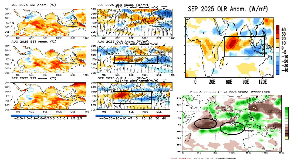
Wyrtki jet ,MJO induced westerly anomalies & NIOD induced westerly anomalies all 3 overlapping over Central-East EQ Indian ocean after mid October & this must be one great time for Bay of Bengal to host a big show.
#MJO #IOD #Negativeiod #Bayofbengal #NEM2025 #Northeastmonsoon

Amazing end September moisture push by the DD 😱
Pure #NegativeIOD magic!
Scattered thundershower activity can be expected in areas where monsoon hasn't withdrawn including Gujarat, eastern Rajasthan with scattered showers around Delhi and west MP, UP too next few days.
#Monsoon2025 will resume withdrawal from north Bharat around 5th Oct.

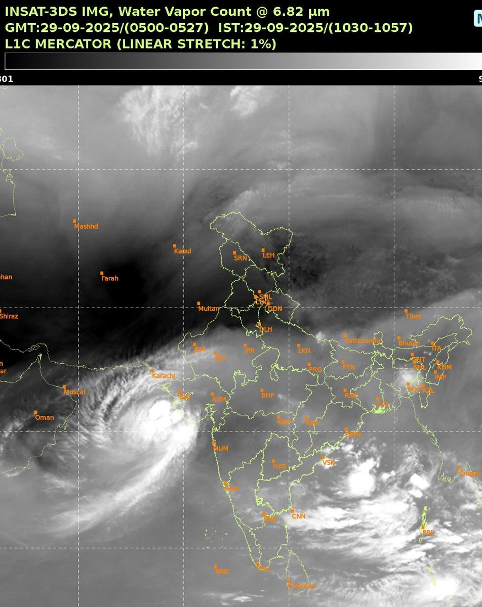
#Monsoon2025 has withdrawn from parts of western #Rajasthan, south #Punjab, west #Haryana, most of #JammuKashmir and #Ladakh.
Withdrawal line passes thru #Barmer, #Churu, #Bhiwani, #Amritsar, #Jammu and #Tangtse.
Conditions fulfilled -
Defined Anticyclone at 850 hPa ✅
Complete cessation of rainfall for more than 5 days ✅
Significant reduction of moisture in mid levels ✅
Monsoon WILL NOT withdraw further now until the first week of October, as the incoming Deep Bay system, post 24th will push in plenty of moisture & rains to remaining north and west India, Delhi NCR included.
Charts INSAT, NCMWRF


#NegativeIOD induced suppression extending into SE arb sea started affecting West coast for the last few weeks emerging as dominant signal in the sub seasonal scale & likely to be significant on a seasonal scale soon
#LaNina #NIOD #Indianocean #India #IOD #Keralarains
@NWSCPC

#IOD has remained negative for the fifth convective week & dropped to -1.2°C, which is it's lowest index since the negative IOD event in 2022.
A #NegativeIOD event is now considered underway. Negative anomalies in WIO however, are quite muted this season, but warming off Indonesia is very strong, that's likely skewed the index into negative.
Atmosphere should begin to respond within 2-3 weeks.
#LaNina continues to develop, will likely show its hand in few months time


#IOD has stayed negative with a value of - 0.91°C for the fourth consecutive week.
A Negative IOD event is very likely by September and can be considered underway if the value remains below threshold for a few more weeks.
This will imply a very wet end to September and indicate delayed #Monsoon withdrawal.
All set for a #NegativeIOD & #LaNina event in the coming weeks/months??
Data : @TropicalTidbits @GHRSST
#Monsoon #IOD #Monsoon2025 #SWM2025 #India #Monsoonupdate #ENSO #Asia


Guess, Who is arriving for our beloved monsoon? #NEM2025
The recent NOAA analysis predicts return of #LaNina & #NegativeIOD conditions by late September and early October. It's going to short lived La-Nina & Negative IOD during Oct 2025 - Jan 2026. Hence, our beloved Northeast monsoon going to driven by most successful pair of La-Nina & NIOD.
Here, we have to note that "it's going to be 5th La-Nina year in last 6 years". Frequent emergence & prolonged behavior of La-Nina conditions has to requires in-depth research.
#Chennairains #NEM2025 #lanina #NIOD #Cyclones #HurricaneSeason


Signals of a negative Indian Ocean Dipole (IOD) developing in the coming months could bring increased risk of heavy rainfall, severe thunderstorms, and tropical cyclones to northern Australia and Indonesia. https://t.co/cenYrXaBDY
#Climate #NegativeIOD #IndianOceanDipole

Large parts of Arabian sea is seen under extensive cooling trend!! will this pave way for Negative IOD event development or just temporary?? Lets see...
Interesting days ahead as we move into peak weeks of monsoon
#Monsoon #Monsoon2025 #SWM2025 #Negativeiod #LaNina #Cooling #Indianocean
DC @TropicalTidbits @GHRSST

These are the past Negative IOD/Negative EQUINOO events during monsoon ..
Open the image in a new tab for a better view..
Chart dc : @NOAA PSL , GPCP rainfall data
#Negativeiod #Monsoon2025 #SWM2025 #Southwestmonsoon #Negativeequinoo #NIOD
#Indianocean

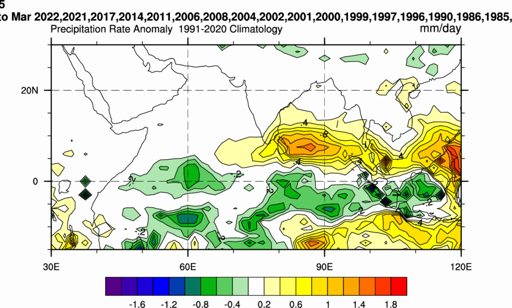
80% of the Jan-Feb-March systems over BOB seen occuring after Previous year #lanina #NegativeIOD events. Bcos of these disturbances, Rainfall also seen enhanced over SE-SW Bay indicating more than the climo mean numbers DC: @ECMWF ERA5 @NOAANCEI @noaaocean
Interesting set of Satellite images collaged to see how active the weather was in #indianocean on this particular day (Nov 16th) during the past #NegativeIOD years. Anomalous westerly wind burst & enhanced convection over EIO adj #sumatra is clearly evident in all those pics.


Thought we'd better get with the program.... 41mm for the day. 37mm since 3pm. Thankfully not widespread.
#lanina #negativeiod

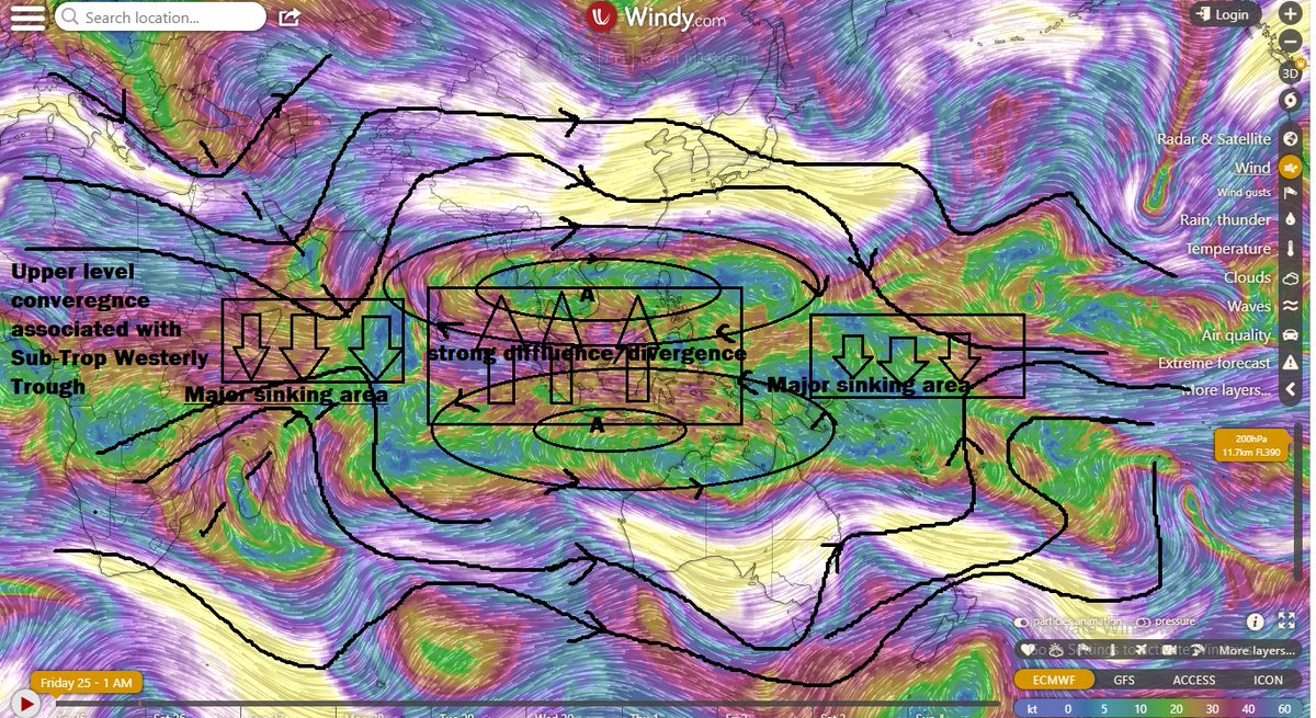
#NegativeIOD/Nina continues to dominate their territory despite #MJO suppression was seen concentrated over EIO/MTC over the last few days. Strong Eq westerly burst over EIO associated with - IOD/Nina state, alongside with ER wave seen counteracting the MJO induced suppression.

Most Popular Users

Elon Musk 
@elonmusk
240.8M followers

Barack Obama
@barackobama
119.2M followers

Donald J. Trump
@realdonaldtrump
111.7M followers

Cristiano Ronaldo
@cristiano
111.2M followers

Narendra Modi
@narendramodi
107M followers

Rihanna
@rihanna
97.8M followers

NASA
@nasa
92.2M followers

Justin Bieber
@justinbieber
91M followers

KATY PERRY
@katyperry
88M followers

Taylor Swift
@taylorswift13
81.8M followers

Lady Gaga
@ladygaga
73.4M followers

Virat Kohli
@imvkohli
70.4M followers

Kim Kardashian
@kimkardashian
69.9M followers

YouTube
@youtube
68.7M followers

Bill Gates
@billgates
64.1M followers

Neymar Jr
@neymarjr
63.2M followers

The Ellen Show
@theellenshow
62.4M followers

CNN
@cnn
61.9M followers

Selena Gomez
@selenagomez
61.1M followers

X
@x
60.8M followers