Top Tweets for #OpenRouteService

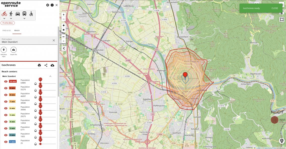
QGIS-Tipp: Plugin ORSTools v.2.0.1 https://t.co/q0rqvTEzcJ #qgis #plugin #switch2qgis #ors #openrouteservice #gistribe #gischat #fossgis #foss4g #OSGeo #spatial #geospatial #opensource #gis #geo #geoObserver pls RT


This is our last post on X. Our account will go dormant tomorrow.
We will keep posting about #openrouteservice, #OpenStreetMap ad other #geodata-related topics on our other social media channels:


With #Streamlit, building apps is easy and fast. On Day 24 of #PythonDatavizChallenge, you will build a Geocoder app that can take an address and display it on the map using #OpenRouteService API. https://t.co/bHmY0V3WTA

Buen lunes!
#30DayMapChallenge día 1: lines, día 2:polygons
"Isócronas a 10, 20, 30 y 40 minutos desde el Centro de la Ciudad de Pergamino por rutas y caminos"
Datos de #IDE #Pergamino y #OpenStreetMap mediante #OpenRouteService.


#30DayMapChallenge Day 4:
🏫Lessons in Traffic🏫
The map shows how rush hour travel times to Nairobi’s Central Business District (CBD) change during school term.
🗺️created with #openrouteservice & #UberMovement data for a study by @maze2punkt0 et al: https://t.co/NzNggC26Ev

#30DayMapChallenge Day 2:
🚗Urban Routing Networks🚗
Using #openrouteservice and #OSM data, @maze2punkt0 analyzed fastest vs shortest car routes in Birmingham & Copenhagen:
🔹Fewer, central roads dominate fastest routes.
🔹Shortest routes spread traffic across more streets.

🚨@ors_news: #openrouteservice update!
#ORS now has #export and #snap endpoints, changing the way users interact with and process routing data, making it easier to handle complex use cases or pre-process points for routing queries.
More info here:
https://t.co/zQfCppOTVR

Did you know❓
#Open #geospatial #data and tools like #openrouteservice are very useful in research and practical applications, as seen in the following case, where #ors was used to model #health and #wellbeing⚕️
🔎Read all about it here:
https://t.co/KBuqPcboO1

❗️Big News❗️
With the EU-Project "Gitterzellendatenbank", @BKG_Bund and partners have taken action to make #FreeOpenGeodata more accessible.
Based on #OSM and #openrouteservice, the project offers information on the reachability of various facilites across Germany.
⬇️More Info

🎉 Exciting news! 🎉 Introducing openrouteservice version 8.0 - "Wilfried"! 🚀 Dedicated to Wilfried Juling for his invaluable contributions. Experience a wave of enhancements and fixes.
Dive in now! https://t.co/Mwir9WYDwp
#openrouteservice #Innovation #HeiGIT #routing

➡️ Das Heidelberg Institute for Geoinformation Technology #HeiGIT und das BKG kooperieren beim Thema #Routing. Auf Basis von #openrouteservice stellt das BKG dem Bund #RoutingPlus bereit.
🗣️ J. Psotta und F. Micklich berichten auf der @FOSSGIS_Konf. ⤵️
https://t.co/yehfNeOjWY

We then learn how to compute the distance between 2 cities - first using the #Python Standard library, then #GeoPy, and eventually learning about Web APIs and calculating real-world driving distance using the #OpenRouteService API. https://t.co/fGo1wqPib7 (3/n)


@geoinquietosarg @idepergamino Pero que complemento lindo este de #OpenRouteService!
Resuelve problemas de ruteo en segundos con datos de #OpenStreetMap.


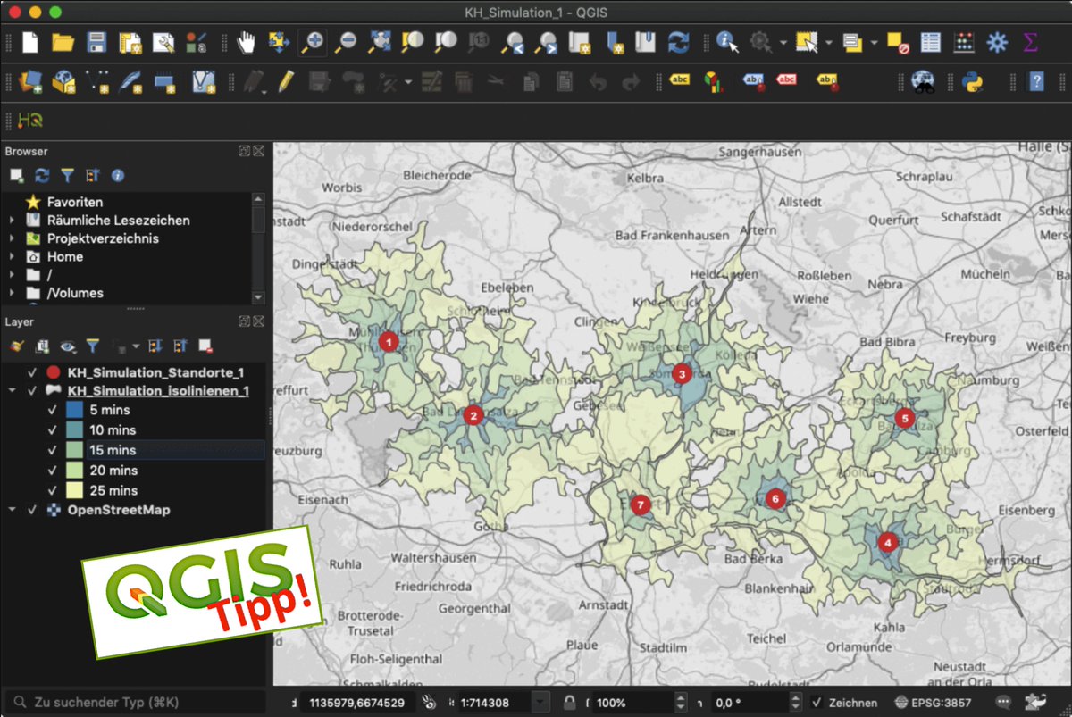
QGIS-Tipp: Krankenhaus-Erreichbarkeit mit ORS (Simulation) https://t.co/qxuOvL2kiH #qgis #switch2qgis #ors #openrouteservice #gistribe #gischat #fossgis #foss4g #OSGeo #spatial #geospatial #opensource #osm #openstreetmap #gis #geo #geoObserver pls RT
#30DayMapChallenge
Día 19: 5-minute map. Spend no more than 5 minutes to prepare this map
"Caminata en intervalos de a 5 minutos desde el centro de la Ciudad"
#OpenRouteService #OpenStreetMap #IDE #Pergamino


Exploring Bruges, Europe's most walkable city according to Motel One study: The Most Walkable Cities in Europe.
#30DayMapChallenge
Day 14 - #Europe | #rstats #Openrouteservice

#30DayMapChallenge
Día 7: Navigation, A map that helps you to navigate
"De una punta a la otra en #Pergamino"
#OpenRouteService es un servicio de ruteo basado en #OpenStreetMap, que puede ser consultado mediante su API.

(1/4) ⛑️ In times of disaster, every second counts. After the #earthquake in #Morocco and the #flood in #Libya affected people are in need of help.
HeiGIT’s #disaster #openrouteservice provides up-to-date routes for affected regions.
Learn how your organization can contribute⬇️


Créditos:
- Mapa de @qgis con mapa base de @openstreetmap e isocrona de #OpenRouteService @ors_news #QGIS
- Frecuencias calculadas con tidytransit en #R
- Info del Observatorio de Barrios Populares: 12 de Julio https://t.co/Y49XenmpV3 y Nueva Esperanza https://t.co/SBx1cVZOVU
We're excited for @foss4g from 26 June – 2 July! Join Christina and Marcel in their workshop on how to use @ors_news in #GIS, and don't miss Christina's presentation on traffic speed modeling with #openrouteservice. See you there! #FOSS4G2023
Read more➡️https://t.co/zR6EV6vQyp
Last Seen Hashtags on Sotwe
Most Popular Users

Elon Musk 
@elonmusk
240.2M followers

Barack Obama
@barackobama
119.3M followers

Donald J. Trump
@realdonaldtrump
111.6M followers

Cristiano Ronaldo
@cristiano
108.9M followers

Narendra Modi
@narendramodi
107M followers

Rihanna
@rihanna
97.3M followers

NASA
@nasa
92.1M followers

Justin Bieber
@justinbieber
90.6M followers

KATY PERRY
@katyperry
86.8M followers

Taylor Swift
@taylorswift13
80.6M followers

Lady Gaga
@ladygaga
72.2M followers

Kim Kardashian
@kimkardashian
69.4M followers

YouTube
@youtube
68.6M followers

Virat Kohli
@imvkohli
68.5M followers

Bill Gates
@billgates
63.4M followers

The Ellen Show
@theellenshow
62.5M followers

CNN
@cnn
61.9M followers

Neymar Jr
@neymarjr
61.1M followers

X
@x
60.9M followers

Selena Gomez
@selenagomez
59.9M followers