Top Tweets for #RSpatial

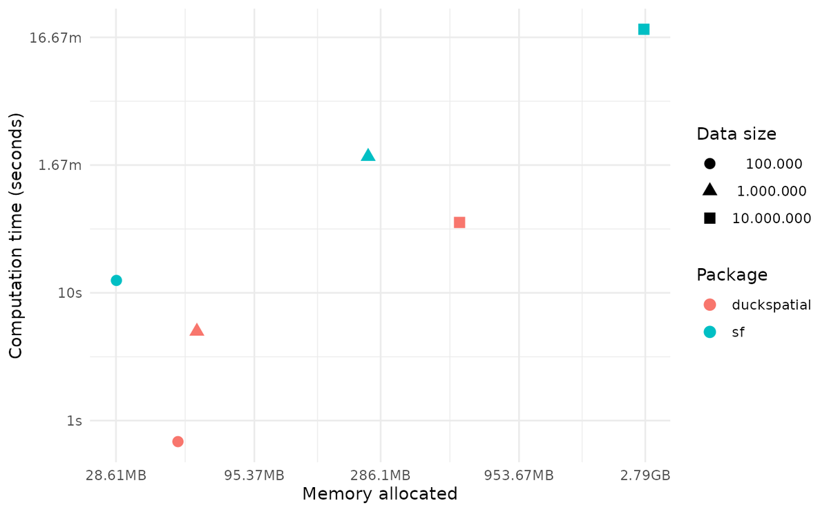
📢{duckspatial} v0.9.0 is now on CRAN !! 🚀 If you work with big spatial data in #rstats, duckspatial brings the power of @duckdb to spatial analysis in R. It is dozenz
- 📦website https://t.co/ezBOhP3LrY
- Blog post: https://t.co/fTl9Bw915x
#duckspatial #rspatial
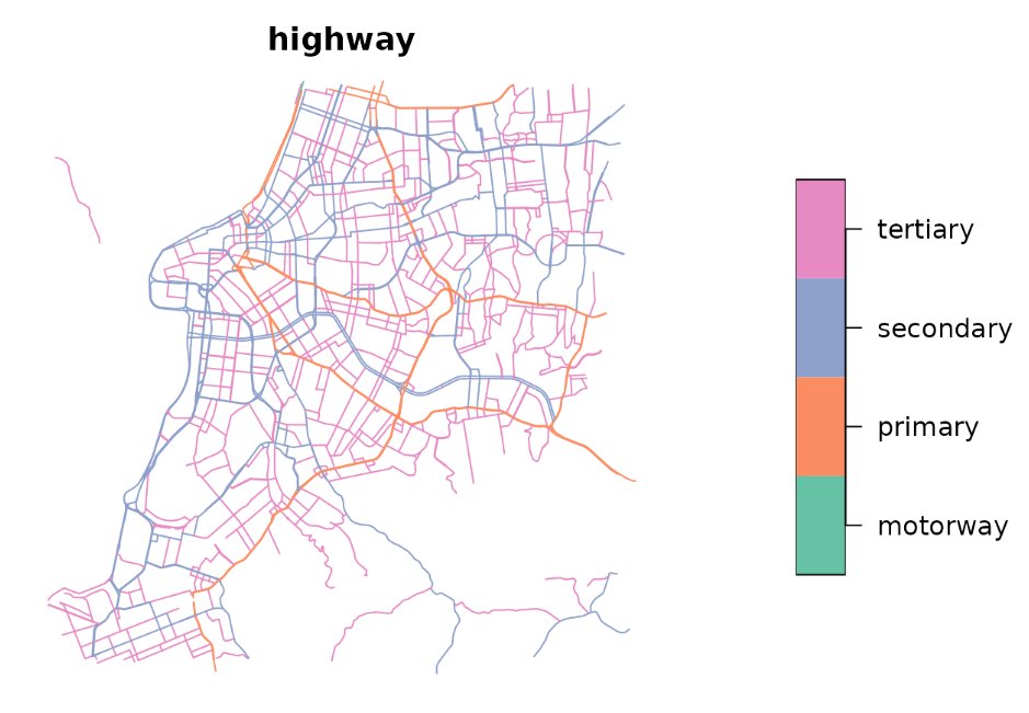
In a benchmark performing a spatial join between 10 million points and 257 polygons, {duckspatial} was 9x faster and used 5x less RAM than {sf}.
#duckspatial is bringging the power of #duckdb to #rspatial

impressionante que tudo que é pra python tem uma aura de picaretagem e lero lero
jamais serão #rspatial

Learning Resources 📚
Big shoutout to @milosmakesmaps for the excellent tutorial that guided this workflow!
YouTube: https://t.co/p9eIXt1A5U
His #rspatial tutorials are 🔥 for anyone wanting to level up their cartography game!

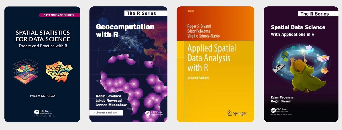
🎉 Top Libros de Análisis Espacial con R (con acceso online gratuito) 🗺️
Si trabajas con SIG y quieres potenciar tus habilidades de análisis de datos geoespaciales, R es una excelente opción.
#rstats #datascience #rspatial #analytics #AnalisisEspacial #GIS #SIG #Geoespacial

#30DayMapChallenge
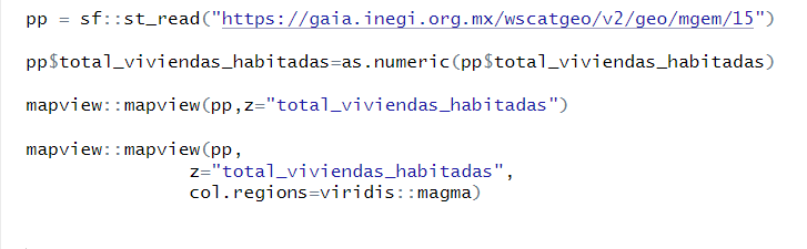
'10 minutes map' Viviendas habitadas por municipio.
Mapa en 4 líneas de código.
Desde @INEGI_INFORMA puedes leer cualquier geometría con datos de población y vivienda a nivel Ent, Mun y Ageb, así como sus vialidades
https://t.co/o6JGK0NcgD
#Rspatial #rstats
#30DayMapChallenge
Día 11 Minimalista Matrices de contigüidad municipal por Estado.
Mi favorito el 28 (Tamaulipas), parece un elefante y el 25 un papalote. #Rstats #Rspatial
Código: https://t.co/9tDra3hTCJ

Añade un minimapa de navegación con addMiniMap() al trabajar con mapas interactivos.
👉 ¿Has usado leaflet o sf en tus proyectos?
#DataScience #RSpatial #DataVisualization #GeospatialAnalysis #Epidemiología #OpenData


👇 Quiero hacer esto en #RStats 🤩
¿Alguien sabe cómo?
#Help #SOS #DataScience #Leaflet #GIS #RSpatial #DataVisualization #GeospatialAnalysis #Epidemiología #OpenData #30DayMapChallenge

#30DayMapChallenge Day 10 — Air
Today’s striking air-quality map from @ClimateTRACE visualizes PM2.5 pollution plumes from thousands of industrial sources around the world. The underlying data show how more than 1.6 billion people live within 10 km of these emissions-intensive facilities.
Explore the map here: https://t.co/TSkdt5ikUK
#BuiltWithMapbox #AirQuality #EnvironmentalData


#Thread (Mini) So Last year I crafted another climateR🌤️🌧️ tutorial using R programming which In this tutorial I've tried to make a shinyapp which non coders could use to quickly visualize annual map #gischat #cartography #GIS #climate #geospatial #dataviz #R #rspatial
#Thread [Update] So Last year I crafted a climateR🌤️🌧️ tutorial using R programming which In this tutorial I'm still going to use The Kingdom of Saudi Arabia 🇸🇦 and one of It's Province, I'll share GitHub link (1/4) #gischat #cartography #GIS #geospatial #dataviz #R #rspatial
![725Hemeed's tweet photo. #Thread [Update] So Last year I crafted a climateR🌤️🌧️ tutorial using R programming which In this tutorial I'm still going to use The Kingdom of Saudi Arabia 🇸🇦 and one of It's Province, I'll share GitHub link (1/4) #gischat #cartography #GIS #geospatial #dataviz #R #rspatial https://t.co/XhTPvOeXYI](https://pbs.twimg.com/media/GJI640AXMAAWe6P.jpg)
![725Hemeed's tweet photo. #Thread [Update] So Last year I crafted a climateR🌤️🌧️ tutorial using R programming which In this tutorial I'm still going to use The Kingdom of Saudi Arabia 🇸🇦 and one of It's Province, I'll share GitHub link (1/4) #gischat #cartography #GIS #geospatial #dataviz #R #rspatial https://t.co/XhTPvOeXYI](https://pbs.twimg.com/media/GJI64zaXQAABU3_.jpg)
![725Hemeed's tweet photo. #Thread [Update] So Last year I crafted a climateR🌤️🌧️ tutorial using R programming which In this tutorial I'm still going to use The Kingdom of Saudi Arabia 🇸🇦 and one of It's Province, I'll share GitHub link (1/4) #gischat #cartography #GIS #geospatial #dataviz #R #rspatial https://t.co/XhTPvOeXYI](https://pbs.twimg.com/media/GJI64iJWsAAAOTa.jpg)

TOMORROW! Scaling the r-spatial ecosystem for the modern composable data pipeline - with Dewey Dunnington, Senior Software Engineer at Wherobots
Tues, June 24, 1pm ET
Sign up now! https://t.co/eUwIWOfNGu
#RStats #rspatial #OpenSource @paleolimbot @wherobots


Actualización de Infografía de Grandes Incendios Forestales en España con datos de 2010 a 2023. Código disponible en https://t.co/G43A4mWxLQ #rstats #rspatial

Mi primera infografía con #rstates Grandes Incendios Forestales en España (2010-2020) con datos del @mitecogob cc: @IncendiosES #rspatial #iiff #IncendiosForestales


#30DayMapChallenge Day 16 - Choropleth
Interactive map of median household income distribution in Hong Kong, made with #RStats
Challenging myself to create a non-static and non-QGIS map, despite a late submission 🤐
#RSpatial

🗺️ Making maps with R 🗺️
Examples of static and interactive maps and mobility flows using {ggplot2}, {leaflet}, {mapview}, {tmap} & {flowmapblue}
👉 https://t.co/ZAIlbYwQ7X
#rstats #rspatial #GISchat #datascience


Last Seen Hashtags on Sotwe
nevşehirgay
Seen from Turkey
humildadypaciencia
Seen from Ireland
nalgasyalgomás
Seen from United States
نيج_كويتى
leak
Seen from Singapore
BreakFastAndWeed
Seen from United States
phanyehernandez
Seen from Singapore
bonnieblue
Seen from India
mom jav
Seen from Singapore
gaziantepesc
Seen from Turkey
Trends for you
Most Popular Users

Elon Musk 
@elonmusk
240.1M followers

Barack Obama
@barackobama
119.3M followers

Donald J. Trump
@realdonaldtrump
111.6M followers

Cristiano Ronaldo
@cristiano
108.9M followers

Narendra Modi
@narendramodi
107M followers

Rihanna
@rihanna
97.3M followers

NASA
@nasa
92.1M followers

Justin Bieber
@justinbieber
90.6M followers

KATY PERRY
@katyperry
86.8M followers

Taylor Swift
@taylorswift13
80.6M followers

Lady Gaga
@ladygaga
72.1M followers

Kim Kardashian
@kimkardashian
69.4M followers

YouTube
@youtube
68.6M followers

Virat Kohli
@imvkohli
68.5M followers

Bill Gates
@billgates
63.4M followers

The Ellen Show
@theellenshow
62.5M followers

CNN
@cnn
61.9M followers

Neymar Jr
@neymarjr
61M followers

X
@x
60.9M followers

CNN Breaking News
@cnnbrk
59.9M followers