

Top Tweets for #RadarSat2

🚢 #ดาวเทียม #Radarsat2 พบคราบ #น้ำมันรั่วไหล จาก #เรือขนส่งตู้สินค้า สัญชาติปานามาอับปาง ณ บริเวณทางด้านทิศใต้ของแหลมพรหมเทพ จ. #ภูเก็ต
🗺️ #GISTDA ได้เผยภาพถ่ายจากดาวเทียม Radarsat-2 เมื่อวันที่ 9 กุมภาพันธ์ 2569 เวลา 18.34 น. พร้อมทำการวิเคราะห์พบคราบน้ำมันที่เกิดการรั่วไหลจากเรือขนส่งตู้สินค้าที่ชื่อ “SEALLOYD ARC” ลอยอยู่บนผิวน้ำ #ทะเลอันดามัน มีลักษณะเป็นทางยาวโดยระยะทางประมาณ 18 กิโลเมตร (กรอบสีแดง) และมีการเคลื่อนตัวไปทางทิศตะวันตกเฉียงเหนืออจากบริเวณที่เรืออับปาง และจากกระแสน้ำที่เกิดขึ้น คาดการณ์ว่าคราบน้ำมันดังกล่าวจะมีการเคลื่อนตัวไปตามทิศทางลมทางทิศตะวันตกเฉียงใต้ จะครอบคลุมพื้นที่เป็นระยะทางยาวประมาณ 48 กิโลเมตร
🌊สามารถตรวจข้อมูลทางทะเลจากเรดาห์ชายฝั่งได้ที่ https://t.co/YItlqIKwy5
อัปเดตข้อมูลแวดวงวิทยาศาสตร์ เทคโนโลยี รู้ทันโลกไอที และโซเชียลฯ ในรูปแบบ Audio จาก AI เสียงผู้ประกาศของ #ThaiPBS ได้ที่ https://t.co/rJNWAvNnmz
🌏 “รอบรู้ ดูกระแส ก้าวทันโลก” ไปกับ #ThaiPBSSciAndTech #Technology #ThaiPBS 💻 https://t.co/vgaGnurg3N


Celebrating #RADARSAT2's belated launch anniversary with this throwback image of the iconic satellite being readied for testing in the DFL vertical (TVAC) chamber.
#MDASpace #RADARSAT2

Happy #InternationalMountainDay!
Here’s a #RADARSAT2 view of Ecuador’s Chimborazo. While it’s not the highest peak in the world, its summit sits ~ 6,384 km from Earth’s centre, beating Everest’s ~ 6,382 km thanks to the planet’s equatorial bulge.
#OnOurRadar #SatelliteImagery


⚒️⚒️ Life Cycle #Mining #Deformation Monitoring and Analysis Using #Sentinel1 and #Radarsat2 #InSAR Time Series
✍️ Zhi Ma et al.
🔗 https://t.co/w6Ku6b36kh


เปิดภาพดาวเทียม น้ำฝั่ง #เมียนมา จม 4,791 ไร่
11 กันยายน สำนักงานพัฒนาเทคโนโลยีอวกาศและภูมิสารสนเทศ หรือ #GISTDA ใช้ข้อมูลจาก #ภาพดาวเทียม #Radarsat2 ของวันที่ 10 กันยายน เวลา 18.15 น.
โดยภาพถ่ายดาวเทียมชี้ให้เห็นน้ำที่ไหลมาจาก #แม่น้ำรวก ทางฝั่งประเทศเมียนมา โดยสัญลักษณ์ สีฟ้า คือ น้ำจากฝั่งประเทศ เมียนมาที่จมน้ำอยู่ 4,791 ไร่ ส่วนสัญลักษณ์ สีแดงคือ น้ำใน อ.แม่สายฝั่งไทยที่ จมน้ำ 6,182 ไร่
โดยค่าเฉลี่ยความลึก อยู่ที่ 1-1.5 เมตร
.
#มติชนออนไลน์ #น้ำท่วมเชียงราย #น้ำท่วมเชียงใหม่ #น้ำท่วมเหนือ


These maps use radar data from #TerraSARX, #RADARSAT2 and the #RCMSatellites to identify potential oil in Manila Bay following the sinking of the Terra Nova tanker in the Philippines: https://t.co/9jgSFwFuzj


Our #RADARSAT2 satellite captured the stark reality of ice loss in the Thwaites Ice Shelf, West #Antarctica in 2022 & 2024. The imagery highlights the rate at which our climate is changing and the importance of protecting our planet. #OnOurRadar #ThwaitesIceShelf #EarthDay 🌍
Hey Spacebound23! It's time to head over to the @MuseumofNature for some networking taking place in the Earth Gallery! It starts at 5pm and we're looking forward to welcoming you as the event sponsor.
#OnOurRadar #RADARSAT2 #Spacebound23 @spacecanada


DYK that RADARSAT-2 images can be used to form a large scale mosaic? This one, of the continent of Africa, consists of approximately 1600 images covering nearly 30 million square kilometers.
#OnOurRadar #AfricaDay #EarthObservation

On #WorldMaritimeDay, we’re shining the spotlight on @GlobalFishWatch using our #RADARSAT2 satellite to fight illegal, unreported & unregulated fishing activities. We've also developed our own Maritime Insights Platform to aid surveillance on sea.
https://t.co/rs9eOxUe4P

It is a profound coincidence that the 1st and 1 millionth #Radarsat2 image are of Sermilik Fjord in eastern #Greenland and that in a mere 15 yrs, the Sermilik glacier has drastically retreated #ClimateChange #ClimateEmergency

RADARSAT-2 took its millionth image! 😮 Learn more about this mission developed by MDA in partnership with the Canadian Space Agency to meet the satellite data needs of the Government of Canada.
https://t.co/6RYivH6PnW
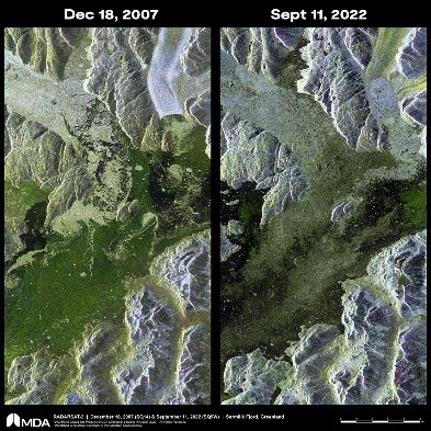
Canada, for the first time, will share a land border on #HansIsland with Denmark, marking the only place in North America where you can cross over to Europe in one step! Our #RADARSAT2 satellite captured the 1.3 square kilometer island surrounded by sea ice back in 2019. 🇨🇦 🇩🇰

🌞#SAR_Fact Monday! ⁉️DYK span is a quantity giving the total power (intensity) received by the channels of a radar system? In the #RADARSAT2 span image from Spring 2016 Manitoba 🇨🇦,we have low span in bare agricultural fields & high span in mixed forest & shrubs area. #EOChat

MDA Maritime Insights™️ enables maritime intelligence users to exploit near real-time #RADARSAT2 SAR vessel detections and other maritime surveillance data to detect and track dark vessel movement activities. Visit our #CANSEC booth (#1021) this week to learn more!
5/5⭐️#SAR_STAR @bindi_dave used C-band #RADARSAT2 fully #polarimetric data for monitoring temporal growth of major summer/monsoon crops including cotton, paddy & gwar & surrounding land use in Hisar district, Haryana 🇮🇳 showing decomposition techniques improved classifications!

🎓#TrainingTuesday! Ever checked out @NRCan #Polarimetric Workstation? From 2010, this #PolSAR tool works with #RADARSAT2, #ALOS & #Convair580 data! https://t.co/PsorxOUdZe #EOChat #TheMoreYouKnow🛰️

But VMS is highly proprietary, so #Op18c only uses AIS.
Analysts can download satellite detections straight from Starboard to compare against other sources of data and decide if a dark detection is worth checking out.
More to come, including results from @MDA_space #Radarsat2
⭐️#SAR_STAR Friday!🥳2nd #Twitterversary Week! @im_nat_cold was 26th! At that time @im_nat_cold thesis focused on the seasonal velocity variability of South Croker Bay & Belcher Glaciers on Devon Ice Cap using #TerraSARX and #RADARSAT2! What's the news, @im_nat_cold? #WomeninSAR
(1/3)⭐️#SAR_STAR! Today, we feature @im_nat_cold, a 2nd year MSc student at @UWaterloo's dept of #Geography & #Environmental management. She has BSc in #Geomatics specialising in #Earth System Science from @UWaterloo. Give her a follow👋 to learn more! #WomeninSAR #WomeninSTEM
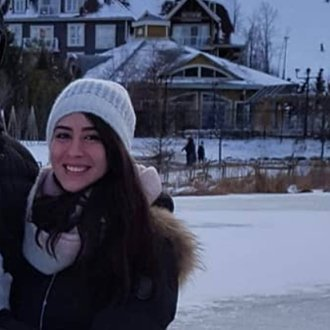
⭐️#SAR_STAR Friday!🥳2nd #Twitterversary Week! @KianaZol was our 21st star in Year 2. @KianaZol is involved in the lake monitoring project & applied AI on long time-series datasets of #RADARSAT1, #RADARSAT2 & #Sentinel1 data using #GEE! How is it going @KianaZol? #WomeninSAR
(1/5)⭐️#SAR_Star! We feature @KianaZol, a research scientist in the @GWFutures project at @UWaterloo. She has a PhD. in #Geography from @UWaterloo, a MSc & BSc in #Geomatics engg. & worked as a postdoc at @AAFC_Canada . Give her a follow👋!
#WomeninSTEM #WomeninRemoteSensing

We're collaborating with @UnseenLabs & @Starboard_NZ at #IndoPacific2022 to ferret out dark vessels that may be associated with illegal fishing. @CanadaInSpace interviews MDA's Mark Carmichael about #RADARSAT2's maritime surveillance capabilities.
https://t.co/m0wMxacJC4
Last Seen Hashtags on Sotwe
Trends for you
Most Popular Users

Elon Musk 
@elonmusk
241.7M followers

Barack Obama
@barackobama
119M followers

Cristiano Ronaldo
@cristiano
114.5M followers

Donald J. Trump
@realdonaldtrump
111.9M followers

Narendra Modi
@narendramodi
107.2M followers

Rihanna
@rihanna
98.7M followers

NASA
@nasa
92.4M followers

Justin Bieber
@justinbieber
91.8M followers

KATY PERRY
@katyperry
90M followers

Taylor Swift
@taylorswift13
84M followers

Lady Gaga
@ladygaga
75.4M followers

Virat Kohli
@imvkohli
73.4M followers

Kim Kardashian
@kimkardashian
70.9M followers

YouTube
@youtube
68.8M followers

Neymar Jr
@neymarjr
66.4M followers

Bill Gates
@billgates
65.2M followers

Selena Gomez
@selenagomez
63.1M followers

The Ellen Show
@theellenshow
62.3M followers

CNN
@cnn
61.8M followers

X
@x
60.7M followers